The perfect place for all your EYFS, KS1 and KS2 resources, Explore Education aims to provide you with amazing, outstanding lessons that help you to shine. Each lesson often has detailed planning, PowerPoints and differentiated resources. So whether you are looking for a maths lesson to get you through your next interview, an English lesson that will help you impress OFSTED or a history, science, RE, PSHE or PE unit to wow your class, this is the shop for you!
The perfect place for all your EYFS, KS1 and KS2 resources, Explore Education aims to provide you with amazing, outstanding lessons that help you to shine. Each lesson often has detailed planning, PowerPoints and differentiated resources. So whether you are looking for a maths lesson to get you through your next interview, an English lesson that will help you impress OFSTED or a history, science, RE, PSHE or PE unit to wow your class, this is the shop for you!
This 10-lesson geography unit is designed for KS2 pupils and covers key topics such as weather, climate zones, and world biomes. Pupils learn to observe local weather, understand climate types across the globe, and explore how climate and biome affect the way people, animals and plants live. The unit builds towards a final report presentation, combining geography knowledge with research and presentation skills.
What’s included:
✔ 10 fully planned lesson overviews with objectives, success criteria and structure
✔ PowerPoint slides for each lesson
✔ Differentiated worksheets and printable activity resources
✔ Word banks, writing frames and support materials for all abilities
✔ World maps, climate zone maps and biome visuals
Lesson overview / structure:
★ Lesson 1: What is the weather like in your local area?
Introduction to weather. Pupils observe, measure and describe daily weather using tools like thermometers and rain gauges.
★ Lesson 2: What are weather, climate and biomes?
Clarifies the difference between weather and climate. Pupils identify global climate zones and are introduced to the concept of biomes.
★ Lesson 3: What are the polar regions and tundra like?
Focus on cold regions of the Earth. Pupils learn about the tundra biome and how animals survive in harsh, cold environments.
★ Lesson 4: What are arid and desert climates like?
Compares polar, subpolar and desert climates. Pupils describe conditions and explore why people and plants find it hard to live in these areas.
★ Lesson 5: What are tropical desert climate zones and biomes?
Zooms in on desert biomes. Pupils locate deserts on a map and describe typical climate features and plant/animal adaptations.
★ Lesson 6: What are tropical rainforest climates like?
Explores the world’s wettest and hottest areas. Pupils learn about the tropical rainforest biome and its link to climate.
★ Lesson 7: What are temperate and Mediterranean climates like?
Pupils compare seasonal changes in temperate and Mediterranean climates, and how these affect clothing, farming and lifestyle.
★ Lesson 8: What is the climate and biome of the UK?
Focuses on the UK’s temperate biome. Pupils consider seasonal changes and how extreme weather and climate change affect daily life.
★ Lesson 9: How does weather vary across the UK?
Pupils use real or fictional data to plot temperature and rainfall on a graph, compare regions and analyse patterns.
★ Lesson 10: Why is climate important?
Pupils create and present a final report showing how climate and biome affect life. Presentation options include posters, slideshows or oral reports.
Why it’s useful:
✔ Fully resourced and ready to teach
✔ Covers geography curriculum objectives clearly
✔ Differentiated tasks for support and challenge
✔ Builds enquiry, data handling and presentation skills
✔ Ideal for whole-class teaching and independent projects
Suggested use cases:
Perfect for Year 3 or Year 4 geography lessons | Ideal for a weather or biomes topic | Suitable for whole term coverage | Supports cross-curricular links with science and literacy
Search tags:
KS2 geography | weather and climate unit | world biomes | Year 4 geography lessons | Year 3 weather topic | KS2 climate zones | map skills KS2 | outstanding geography planning | UK weather comparison | world climates KS2 | full unit geography scheme
This free lesson overview provides a clear breakdown of each lesson in a 10-lesson geography unit focused on weather, climate, and world biomes. Ideal for teacher planning and curriculum mapping in KS2.
You can buy our bundle for this unit including lesson plans, PowerPoints and all worksheets and resources below:
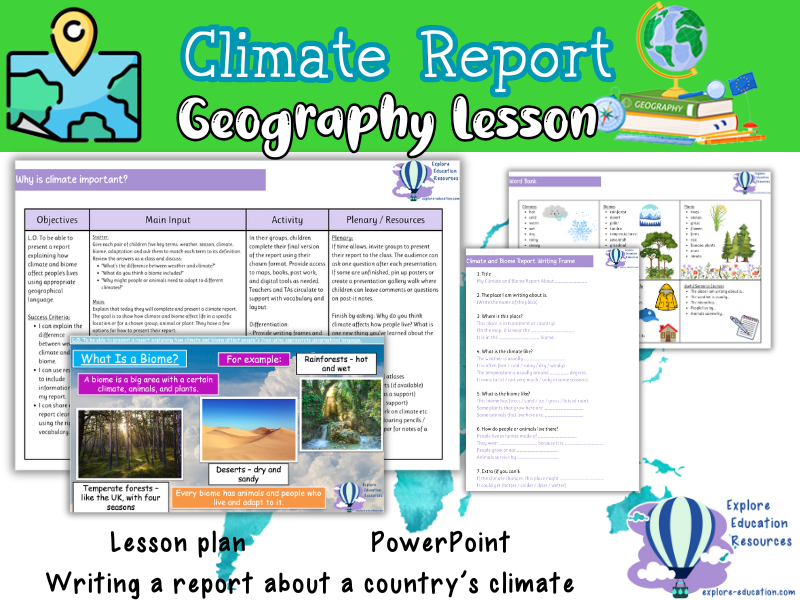
This lower KS2 geography lesson teaches pupils how to present a report explaining how climate and biome affect life in different parts of the world. Pupils use geographical vocabulary and research to create and present a report in a format of their choice. Ideal for building cross-curricular skills in writing, geography, and speaking.
What’s Included:
✔ Editable PowerPoint presentation
✔ Report writing frames
✔ Vocabulary word bank
Lesson Overview / Structure:
★ Starter: Pupils work in pairs to match five key terms (weather, season, climate, biome, adaptation) to their definitions. Class discussion follows on the difference between weather and climate and why adaptations are needed.
★ Main Activity:
– Pupils plan and complete a report on how climate and biome affect life in a chosen location, species, or community.
– Suggested formats: poster, slideshow, or oral presentation with visuals.
– Pupils include: name and location, climate description, biome features, and effects on daily life.
★ Support and Challenge:
– Support: Writing frame and vocabulary banks available.
– Challenge: Include comparisons with the UK or predictions linked to climate change.
★ Plenary:
– Pupils present their report or take part in a gallery walk with peer questions or comments.
– Final reflection questions: “Why does climate affect how people live?” and “What’s one new thing you’ve learned about world climates?”
Why It’s Useful:
✔ Encourages cross-curricular links with geography, literacy, and speaking
✔ Allows pupils to choose from multiple presentation styles
✔ Develops use of key vocabulary and report-writing skills
✔ Supports understanding of global climate and adaptation
Perfect for lower KS2 geography units on climate and biomes, end-of-unit assessment tasks, or integrated humanities projects. Works well in group, pair or individual formats.
Search Tags:
KS2 geography | climate and biome report | Lower KS2 weather lesson | Year 3 climate writing | climate adaptation project | outstanding geography lesson KS2 | world biomes KS2 | writing about weather and climate KS2 | climate change and adaptation UK curriculum
This fully resourced KS2 geography lesson teaches pupils how to interpret and present weather data using tables, bar charts, and choropleth maps. Designed for Year 3 or Year 4, the lesson focuses on identifying how weather varies across the UK and using weather data to spot patterns.
What’s Included:
✔ PowerPoint presentation
✔ Weather data table (example UK locations)
✔ Blank bar chart templates
✔ Sentence stems for support
✔ Differentiated comparison task
✔ Printable resources for graphing
✔ Plenary discussion prompts
Lesson Overview / Structure:
★ Starter: Pupils analyse weather photos from across the UK and discuss visible differences in conditions. A class list of descriptive weather terms is created.
★ Main Input: Teach pupils how weather is measured and how data is collected (rainfall and temperature). Use a weather data table and demonstrate how to transfer this into a bar chart. Introduce a UK choropleth map and teach pupils how to read the key and identify patterns.
★ Activity: Pupils create their own bar charts using local or example weather data. They write three comparative sentences based on what they notice.
★ Differentiation:
– Support: Pre-labelled bar chart template and sentence stems.
– Challenge: Pupils calculate averages and describe trends in the data.
★ Plenary: Use speech bubble prompts to discuss how data can reflect lived experiences of weather. Children explain their reasoning using evidence from their charts or maps.
Why It’s Useful:
✔ Builds geographical skills using real-world data
✔ Supports cross-curricular links with maths (data handling)
✔ Encourages critical thinking and reasoning
✔ Differentiated for a range of abilities
Ideal for Year 3 or Year 4 geography lessons focusing on weather, data interpretation, or UK climate zones. Can also be used for science or cross-curricular topics involving graphing skills.
Search Tags:
KS2 geography | UK weather lesson | weather data bar chart | Year 4 climate activity | interpreting data KS2 | weather comparison UK | outstanding data handling | map skills KS2 | climate variation UK | primary geography resources
This KS2 geography lesson introduces pupils to the temperate climate zone, focusing on the UK’s climate and its impact on people, plants, and animals. It also includes an introduction to biomes and a gentle discussion about climate change and its effects.
What’s Included:
✔ PowerPoint presentation for direct teaching
✔ Temperate biome fact sheet
✔ Poster template for pupil work
✔ Word bank and picture prompts for support
✔ Link to child-friendly climate change video
Lesson Overview / Structure:
★ Starter: Children locate the UK on a world map and describe its position relative to the Equator and poles. They write three adjectives to describe the UK’s weather.
★ Main Activity: Introduce temperate climate zones and explain how they differ from tropical and polar regions. Use images to show the UK’s biome (deciduous forest) and discuss seasonal changes, weather, plants, and animals. Children complete a poster showing features of the UK’s climate, flora, fauna, and human activity.
★ Differentiation:
– Support: Word bank and images
– Challenge: Include examples of how extreme weather can impact life in the UK
★ Plenary: Watch a short video introducing the idea of climate change. Discuss how future weather changes might affect people and nature. Children reflect on the key facts learned.
Why It’s Useful:
✔ Aligned with UK geography curriculum (KS2 climate zones and biomes)
✔ Encourages awareness of climate and seasonal changes
✔ Differentiated for a range of learners
✔ Supports geography, science, and PSHE links
Ideal for Year 3–4 geography lessons focused on climate, UK weather, biomes, or sustainability topics. Can also support work on seasons, ecosystems, or environmental change.
Search Tags:
KS2 climate zones | UK weather lesson | temperate biome Year 4 | deciduous forest KS2 | geography UK seasons | outstanding geography resource | climate change Year 3 | UK biome worksheet | British trees lesson KS2 | climate teaching pack KS2
This lesson introduces KS2 students to the unique characteristics of temperate and Mediterranean climate zones. Pupils explore key concepts such as weather patterns, climate influences, and biome distinctions while developing essential map-reading and comparison skills.
What’s Included:
✔ Editable PowerPoint presentation
✔ Printable fact file sheets
✔ Comparison table worksheet
✔ Postcard template for extension activity
✔ Lower ability postcard support sheet
✔ x2 Postcard WAGOLLs
✔ Lesson plan
Lesson Overview / Structure:
★ Starter: Engage students with a quick activity to spark discussion about different climate zones.
★ Main Activity: Use visual aids and a digital map to examine the features of temperate and Mediterranean climates, supported by fact sheets.
★ Independent/Group Activity: Students complete a comparison table and work on a creative extension task using the postcard template.
★ Plenary: Wrap up with a brief review and discussion to reinforce key vocabulary and concepts.
Why It’s Useful:
✔ Enhances understanding of global climate differences
✔ Develops map skills and data comparison techniques
✔ Provides differentiated support for mixed-ability groups
✔ Aligns with national KS2 geography curriculum outcomes
Ideal for KS2 geography lessons, cross-curricular projects linking to science and social studies, and group discussion activities. Suitable for whole-class instruction or small group work.
Search Tags:
KS2 geography | temperate climate lesson | Mediterranean climate comparison | Year 4 geography | outstanding geography resource
This KS2 geography lesson introduces pupils to the climate, location and features of tropical rainforest regions around the world. Pupils learn how climate zones and biomes are connected and use maps and group activities to research key regions such as the Amazon and Southeast Asia.
What’s Included:
✔ Editable teaching PowerPoint
✔ Blank world map for labelling climates and rainforests
✔ Printable rainforest fact file template (for lower-ability pupils)
✔ Detailed lesson plan
★ Lesson Overview / Structure:
★ Starter: Use a coloured world rainfall map to prompt discussion about the wettest places on Earth and introduce the concept of tropical rainforests.
★ Main: Pupils learn about monsoon rain using examples from India. Introduce the term ‘tropical rainforest biome’ and explore crops, animals and homes found in these regions.
★ Independent Task: Pupils locate and label four rainforest regions and create a page describing the climate, rainfall and biome features. Pages are combined to form a group rainforest book.
★ Plenary: Reflect on life in a rainforest environment through guided imagination and class discussion.
Why It’s Useful:
✔ Builds understanding of climate zones, biomes and geography vocabulary
✔ Includes group research and mapping task
✔ Differentiated support materials included
KS2 geography topic work | Year 3–4 climate zones and biomes | World map skills | Cross-curricular work with science or PSHE
Search Tags:
KS2 geography | climate zones lesson | tropical rainforest biome | Year 3 rainforest | monsoon lesson plan | world rainfall map KS2 | outstanding geography resource | KS2 biomes and climate zones | rainforest research project KS2
This KS2 geography lesson introduces pupils to tropical desert climate zones and biomes. Ideal for Years 3–4, the resource helps children understand key features of hot, dry environments and the impact of climate on landscapes, wildlife, and human life. The activity also supports world map skills and topic vocabulary.
What’s Included:
✔ Editable PowerPoint presentation
✔ Blank world map worksheet
✔ Tropical desert information sheets
✔ Differentiated support sheet
✔ Exemplar answers for each ability
★ Lesson Overview / Structure:
★ Starter: Introduces the concept of hot and dry places using a temperature map
★ Main Input: Pupils locate key deserts and learn about climate and biome features
★ Activity: Children label deserts on a world map and describe the desert biome using support materials
★ Extension: Comparison of two desert regions and how humans adapt
★ Plenary: Class quiz and vocabulary recap
Why It’s Useful:
✔ Supports understanding of climate, biomes, and world geography
✔ Builds map skills and geographical vocabulary
✔ Includes differentiation for a range of abilities
✔ Flexible for independent or group learning
KS2 geography | World climate zones | Desert biome studies | Year 4 map skills | Comparing global environments | Geography and science cross-curricular links
Search Tags:
KS2 geography | tropical deserts KS2 | desert biome lesson | Year 4 geography climate | hot and dry zones KS2 | outstanding desert lesson | arid zones map | Year 3 world biomes | desert animals KS2
This KS2 geography resource helps pupils compare the climate and living conditions of polar, subpolar and arid regions. Suitable for Years 3–4, the lesson introduces key differences in temperature, rainfall and habitability, with a focus on map skills and geographical vocabulary.
What’s Included:
✔ Editable PowerPoint
✔ x3 Climate zone comparison worksheets (differentiated)
✔ Information cards for polar, subpolar and arid zones
✔ Matching activity sheet with environment images
★ Lesson Overview / Structure:
★ Starter: Children observe mystery climate photos and make predictions
★ Input: Teacher-led introduction to the polar, subpolar and arid climate zones using map visuals
★ Main Task: Pupils complete a guided comparison table using climate data and key facts
★ Extension: Matching activity linking environments to their climate zone
★ Plenary: Partner discussion and vocabulary recall
Why It’s Useful:
✔ Clear links to the national curriculum for geography
✔ Supports map skills and use of geographical vocabulary
✔ Differentiated worksheets and extension task included
✔ Encourages critical thinking and group discussion
KS2 geography | Climate zones topic | Comparing extreme environments | Whole-class map skills lesson | Cross-curricular geography and science
Search Tags:
KS2 geography | climate zones KS2 | comparing polar and arid climates | Year 4 geography lesson | polar vs desert climate KS2 | outstanding geography resource | climate comparison activity KS2 | Year 3 climate lesson | subpolar zone worksheet
This lower KS2 geography lesson introduces children to the climate and features of the polar regions and tundra biome. Designed for Years 4–6, the resource helps pupils understand key differences between the Arctic and Antarctic, develop map skills, and consider how animals survive in extreme conditions.
What’s Included:
✔ Editable PowerPoint presentation
✔ x3 Differentiated Polar regions comparison worksheets and answers
✔ Printable fact cards for Arctic and Antarctic
✔ Tundra biome fact sheet
Lesson Overview / Structure:
★ Starter: Children identify the coldest parts of the world using a map and temperature zones
★ Main Input: Introduces key facts about the Arctic, Antarctic, and tundra biome using visuals and discussion prompts
★ Paired Task: Pupils complete a polar comparison chart using fact-based clues
★ Follow-Up Activity: Children select and label an animal adapted to cold climates
★ Plenary: Class quiz recap to reinforce main differences between polar regions
Why It’s Useful:
✔ Encourages map reading and geographical vocabulary
✔ Supports understanding of climate zones and biomes
✔ Includes differentiated tasks for varied ability levels
✔ Ready to use with minimal preparation
KS2 geography | Climate zones and biomes topic | Whole-class or group lesson | Lesson observations or display work | Science and geography link
Search Tags:
KS2 geography | polar regions lesson | tundra biome KS2 | Year 4 geography | Arctic and Antarctic comparison | outstanding climate lesson | Year 5 map skills | Year 6 geography topic | cold climates KS2
A clear, engaging KS2 geography lesson introducing weather, climate and biomes. Suitable for Year 3 or Year 4, this resource uses maps and visual prompts to help pupils build key vocabulary and understand climate variation around the world.
What’s Included:
✔ Detailed lesson plan
✔ Teaching PowerPoint (fully editable)
✔ Printable world map worksheet (blank climate zones)
✔ Biome picture cards for sorting or discussion
★ Lesson Overview:
★ Starter: Pupils begin by discussing weather in their local area and comparing seasons.
★ Main Input: Key terms such as weather, climate and biome are explained with visual prompts.
★ Activity: Children use the blank world map and biome cards to identify and link different climates and natural environments.
★ Plenary: A short reflective task encourages pupils to summarise their learning using new vocabulary.
Why It’s Useful:
✔ Focuses on vocabulary and visual learning
✔ Supports geographical knowledge and map skills
✔ Easy to adapt for different abilities or lesson lengths
✔ Ideal for introducing biomes and climate zones in a simple way
Suggested Use Cases:
KS2 geography | Year 3 climate lesson | Year 4 weather and biomes | whole class teaching | map work | geography starter lesson | curriculum-linked vocabulary work
Search Tags:
KS2 geography | weather climate biomes | Year 3 lesson | Year 4 geography | climate zones worksheet | world map activity | outstanding primary geography | lower KS2
A fully resourced geography lesson for Lower Key Stage 2 focusing on observing, measuring and describing local weather. Designed to support understanding of weather vocabulary, instruments, and differences across locations in the UK. Ideal for developing enquiry skills through practical data collection.
What’s Included:
✔ Detailed lesson plan
✔ Teaching PowerPoint
✔ Weather recording sheet
✔ Rain gauge instructions
✔ List of required materials
Lesson Overview / Structure:
★ Introduces key terms and weather symbols
★ Practical group task to observe and record weather data
★ Differentiated activities to support discussion and analysis
★ Opportunities to develop vocabulary and reasoning
★ Includes group reflection and simple assessment task
Why It’s Useful:
✔ Clear, structured approach to teaching weather concepts
✔ Supports outdoor learning and real-life data collection
✔ Differentiated to suit a range of learners
✔ Cross-curricular links to science and maths
✔ Minimal prep required for class teachers
Suitable for KS2 geography lessons | Weather and climate topics | Local area fieldwork | Outdoor learning sessions | Whole-class or group enquiry
Search Tags:
KS2 geography | weather observation KS2 | Year 3 geography lesson | Year 4 weather investigation | measuring rainfall activity | rain gauge KS2 | LKS2 geography planning | outdoor geography KS2 | outstanding KS2 weather lesson | climate vs weather KS2
Fully resourced for map skills, classification, and geographical understanding | Ideal for 30–60 minute lessons
This outstanding-rated Key Stage 2 geography lesson focuses on identifying and differentiating between human and physical geographical features, offering an interactive and engaging way to explore maps and geographical concepts.
Designed for KS2 students, this flexible session can be used in a 30-minute or 1-hour format, making it perfect for regular geography lessons, Ofsted observations, or NQT interview lessons.
What’s included:
✔ A clear and structured PowerPoint presentation to guide the lesson
✔ Activity sheets for hands-on learning, including map identification tasks
✔ Extension activities, including a task on map features of London using compass points
✔ Focus on key skills:
Identifying human and physical features on a map
Comparing and classifying geographical features
Creating and labelling maps with identified features
Why this lesson stands out:
✔ Combines map skills, classification, and practical application
✔ Supports understanding of geographical features and their differences
✔ Adaptable for different abilities and lesson timings
✔ Ready-to-use with minimal prep – ideal for busy teachers and formal observations
Perfect for:
KS2 geography lessons
Map skills and geographical features units
Intervention groups and booster sessions
Ofsted observation lessons
NQT interview lessons
Search terms: KS2 human and physical features | map skills geography | Year 6 geography lesson | KS2 map features | London map extension activity | geographical classification | KS2 geography observation | compass points activities
Are you looking for a way to spice up your geography lessons and inspire your KS2 students? Do you want to cover the key concepts of compass directions, human and physical features, and physical features of the UK in a fun and interactive way? If so, this bundle of outstanding geography lessons is perfect for you!
This bundle includes 3 comprehensive and engaging lessons, each with a detailed lesson plan, a captivating PowerPoint presentation, and a range of activity sheets. The lessons are designed to help your students develop their geographical skills and knowledge, as well as their creativity and critical thinking. The lessons are:
☆ KS2 Compass Directions: In this lesson, students will learn about the cardinal and intercardinal points of the compass and how to use them to write directions for a journey on a map. They will also practice their map reading and direction writing skills with a practical application task. An extension activity is included to challenge early finishers.
☆ KS2 Human and Physical Features: In this lesson, students will learn to identify and differentiate between human and physical geographical features on a map. They will also create their own map with identified features using their imagination and creativity. An extension activity is included to challenge students with a map of London using compass points.
☆ KS2 Physical Features of the UK: In this lesson, students will learn about the main physical features of the UK, such as mountains, rivers, lakes, and coasts. They will also explore how these features affect the climate, wildlife, and human activities in different regions. An extension activity is included to challenge students with a quiz on the physical features of the UK.
By purchasing this bundle, you will save 22% compared to buying each lesson individually.
Special Offer
You will also receive a complimentary resource of your choice if you leave a review and email us your purchase receipt and a screenshot of your review to explore_education@outlook.com.
You may also be interested in…
☆ KS2 Europe - Outstanding Geography Unit
☆ KS2 LONGITUDE and LATITUDE Outstanding Lesson - Geography
☆ KS2 France Geography Unit - 5 outstanding lessons
This bundle is ideal for teachers who want to deliver outstanding geography lessons that are both informative and enjoyable. Your students will love learning about the world around them with these resources!
Tags: KS2, Key Stage 2, Geography, Compass Directions, Human Features, Physical Features, Lesson Plan, PowerPoint, Activity Sheets, Map Reading, Map Identification, Map Creation, London Map, UK Features, Education.
Fully resourced for interactive learning and geographical exploration | Ideal for 60-minute lessons
Are you looking for an engaging way to teach your KS2 students about the physical features of the UK? This outstanding geography lesson is designed to develop their geographical skills, deepen their understanding of the UK’s diverse landscapes, and inspire curiosity through interactive tools and hands-on activities.
What’s included:
✔ A detailed lesson plan with clear learning objectives and structured activities
✔ A captivating PowerPoint presentation to support the lesson and visualise key geographical concepts
✔ A range of activity sheets to reinforce learning and encourage independent thinking
✔ Guided instructions for using Google Maps to compare UK regions and their physical features
✔ A presentation template for students to create a comparison between East Anglia and Cumbria
✔ Extension activities for comparing other regions of the UK using structured templates
Skills and knowledge covered:
Identifying Physical Features: Learn about mountains, rivers, lakes, coasts, and islands in the UK
Google Maps Exploration: Use Google Maps to compare the physical features of different UK regions
Comparative Analysis: Discuss how physical features impact tourism, agriculture, industry, and transport
Presentation Creation: Present a comparison of two UK regions, using a structured guidelines sheet
Extension Activity: Compare other regions of the UK and their physical features with a template to organise their findings
Why this lesson stands out:
✔ Encourages geographical exploration and critical thinking
✔ Supports cross-curricular learning with ICT, English, and PSHE
✔ Provides hands-on activities and real-world application through Google Maps
✔ Adaptable for different ability levels and lesson durations
✔ Ready-to-use with minimal prep – ideal for busy teachers or formal observations
Perfect for:
KS2 geography lessons
Developing map reading and comparison skills
Cross-curricular projects involving geography, ICT, and English
Supporting National Curriculum objectives for geography
Observation or interview lessons
Search terms:
KS2 geography lesson | physical features of the UK | comparing UK regions | geography lesson plans | Google Maps UK geography | physical geography KS2 | comparative analysis | UK physical features lesson | KS2 geography presentation
Fully resourced for hands-on learning and map skills | Ideal for 60-minute lessons
This engaging and educational KS2 geography lesson focuses on compass directions, helping students understand both cardinal and intercardinal points while encouraging practical map-reading skills. The resource includes a well-structured lesson plan, a visually engaging PowerPoint presentation, and interactive activity sheets that guide students in applying their knowledge of compass directions to map reading and writing directions.
What’s included:
✔ A comprehensive lesson plan to ensure a smooth and impactful teaching experience
✔ A PowerPoint presentation that introduces and reinforces compass directions
✔ Interactive activity sheets that support students in applying their knowledge to real-world map reading and direction writing
✔ Practical activities where students use compass skills to create written directions for a journey
✔ Extension tasks for early finishers, offering additional challenges to deepen understanding
Skills and knowledge covered:
Cardinal and Intercardinal Directions: Understanding the basic compass points (north, south, east, west) and their intercardinal counterparts (northeast, southeast, northwest, southwest)
Map Reading: Developing map-reading skills by using compass directions to follow and write directions
Practical Application: Writing directions for a journey based on map reading
Extension Activity: Providing a challenge for early finishers to extend their learning of compass directions
Why this lesson stands out:
✔ Offers an interactive, hands-on approach to learning compass directions
✔ Supports the development of map-reading and spatial awareness skills
✔ Adaptable to different ability levels and lesson durations
✔ Ready-to-use with minimal preparation, perfect for busy teachers or observation lessons
✔ Combines theoretical knowledge with practical application for a well-rounded learning experience
Perfect for:
KS2 geography lessons on compass directions
Teaching map skills and spatial awareness
Cross-curricular activities involving geography and literacy
Observation or interview lessons
Geography mastery-style teaching
Search terms:
KS2 geography lesson | compass directions lesson | map reading KS2 | cardinal and intercardinal directions | geography lesson plans | direction writing | KS2 geography activities | compass skills lesson
This Key Stage 2 geography unit includes eight fully planned lessons focusing on European landmarks, cultural similarities and differences, trade links, and environmental conditions. Pupils will develop geographical knowledge, map skills, data handling, and critical thinking through interactive activities and discussions.
What’s included:
✔ Eight detailed lesson plans covering objectives, activities, discussions, and outcomes
✔ Worksheets and tasks for map work, research, debate, and data analysis
✔ Activities such as travel brochure creation, planning travel adventures, and graphing climate data
✔ Opportunities for individual, group, and whole-class learning
Lesson overview / structure:
★ Lesson 1: Introduction to Europe – countries, geographical features, and significance
★ Lesson 2: European landmarks – location, historical and cultural importance, map activities
★ Lesson 3: Cultural similarities and differences – traditions, languages, and customs compared to local area
★ Lesson 4: Trade and travel connections – imports, exports, tourism, and geographical influences
★ Lesson 5: Planning a European travel adventure – itinerary building and research
★ Lesson 6: Expressing personal views about European locations – discussion and debate activities
★ Lesson 7: Geographical similarities and differences – comparing Spain with the local area
★ Lesson 8: Graphing and comparing geographical data – analysing temperature and rainfall patterns
Why it’s useful:
✔ Builds strong geographical knowledge and skills across KS2
✔ Supports critical thinking through discussions, comparisons, and evaluation
✔ Offers varied tasks to support different learning styles and abilities
✔ Encourages use of maps, graphs, and data in geography
✔ Ready-to-use lessons saving planning time
Suggested use cases:
Ideal for KS2 geography units on Europe, cross-curricular projects linking geography with English or maths skills, independent research tasks, and group discussions. Also suitable for revision and KS3 foundation lessons.
Search terms: KS2 Europe geography | European landmarks KS2 | KS2 cultural similarities | European environment KS2 | Key Stage 2 geography unit | KS2 geography lessons Europe | Spain UK comparison KS2 | KS2 map skills
Fully resourced with lesson plan, PowerPoint and data activities | Ideal for geography and cross-curricular maths
This engaging and well-structured KS2 geography lesson supports pupils in exploring temperature and rainfall across Europe, while building important data handling and graphing skills. Perfect for a full lesson or as part of a wider unit on European geography, climate, or environmental patterns.
Designed for primary learners, the lesson encourages pupils to collect, analyse, and represent real-world data through group discussion and graphing tasks.
What’s included:
✔ Detailed lesson plan with clear learning objectives and success criteria
✔ Interactive PowerPoint presentation to introduce and guide each activity
✔ Printable worksheets and data sets on temperature and rainfall in European locations
✔ Graphing task sheets (paper-based or software-friendly)
✔ Prompts for group discussion, comparison and prediction tasks
Lesson structure:
★ Starter activity – pupils reflect on their prior knowledge of Europe’s weather and geography
★ Main input – interpreting temperature and rainfall data using clear units of measurement
★ Activity 1 – small group analysis of data sets and prediction-making
★ Activity 2 – graph creation using paper or digital tools, with a focus on labelling and scales
★ Activity 3 – whole-class comparison of graphs and shared findings
★ Plenary – reflection on environmental differences across regions and key learning points
Why teachers love it:
✔ Combines geography and maths skills in a real-world context
✔ Encourages group work, critical thinking and clear data presentation
✔ Flexible delivery for one-off lessons or topic units
✔ Ready to use – minimal prep required
Perfect for:
KS2 geography (Years 3–6)
European geography and climate topics
Data handling in cross-curricular maths
Whole-class, group or paired learning
Lessons focused on environmental patterns and comparing regions
Search terms: Europe geography KS2 | temperature and rainfall data | graphing lesson | comparing climates | KS2 geography skills | primary data handling | weather patterns Europe | environmental differences | climate graphs KS2
Explore culture, trade and travel through geography | Includes lesson plan, PowerPoint, maps and resources
This fully resourced KS2 geography lesson helps children compare and contrast Spain and the United Kingdom, with a focus on culture, trade, and travel. Pupils will explore how geography shapes the way people live, what they trade, and how they connect across Europe.
Designed to encourage discussion, collaboration and critical thinking, this lesson is perfect for deepening pupils’ understanding of global connections in an accessible and engaging way.
What’s included:
✔ Detailed lesson plan with objectives, success criteria and suggested questions
✔ PowerPoint to introduce and guide the lesson
✔ Cultural comparison cards for group work
✔ Maps and worksheets to explore trade routes and geography
✔ Prompts for class discussion and plenary reflection
Activities in this lesson:
☆ Compare traditions and languages using cultural cards
☆ Explore trade and travel routes with map-based tasks
☆ Understand how geography influences culture, trade and movement
☆ Group discussion to summarise learning and reflect on connections
Why teachers love it:
✔ Supports geographical thinking and cultural understanding
✔ Encourages children to explore both similarities and differences
✔ Combines physical and human geography in a real-world context
✔ Ideal for class topics on Europe, global connections or comparative studies
✔ Fully resourced and easy to deliver
Perfect for:
KS2 geography (Years 3–6)
European geography topics
Cross-curricular links with PSHE, citizenship or languages
Comparing human and physical geography across countries
Whole-class, group or paired work
Search terms: Spain and UK geography | comparative geography KS2 | trade and travel Europe | culture comparison lesson | KS2 geography lesson plan | physical and human geography | Europe topic KS2 | Year 4 geography | comparing countries lesson
Ideal for discussions, group work and classroom displays | No prep required
This engaging and fully resourced Geography lesson on Europe is perfect for introducing pupils to the diverse cultures, climates and landmarks across the continent. Suitable for Years 3–6 and easily adaptable for lower KS3 (Years 7–8), it’s ideal for humanities lessons, Ofsted observations, interviews or supply teaching.
The lesson encourages pupils to share their ideas, reflect on places they’ve heard of or would love to visit, and build a deeper understanding of how geography influences opinion and interest.
What’s included:
✔ Lesson plan with clear learning objectives and success criteria
✔ PowerPoint presentation with images and discussion prompts
✔ Collage template for group or individual work
✔ Discussion task cards for small group activities
✔ Optional writing sheet for presenting top European destinations
Lesson structure:
★ Starter – Pupils reflect on European places they know or would like to visit
★ Main input – Images and videos introduce different parts of Europe, encouraging discussion around culture, landmarks, and climate
★ Activity 1 – Pupils create collages of favourite European destinations
★ Activity 2 – Group discussions around dream holidays and how geography influences choices
★ Activity 3 – Pupils present their top European pick using facts or stories
★ Plenary – A gallery walk and reflection on what’s been shared and learned
Why teachers love it:
✔ Promotes curiosity and respectful discussion
✔ Encourages speaking and listening skills
✔ Builds cultural awareness through geography
✔ No marking required – ideal for observations or supply teaching
✔ Adaptable for 30-minute or 1-hour lessons
Perfect for:
KS2 and lower KS3 Geography or Humanities
Cultural awareness and European studies
Interview lessons or Ofsted observations
Classroom displays and speaking activities
No-prep cover lessons or supply teaching
Search terms: Europe geography KS2 | KS3 culture and landmarks | European countries lesson | Year 4 humanities | KS2 speaking and listening | ofsted geography lesson | interview lesson KS2 KS3 | supply teacher no prep | explore Europe lesson | discussion-based lesson