The perfect place for all your EYFS, KS1 and KS2 resources, Explore Education aims to provide you with amazing, outstanding lessons that help you to shine. Each lesson often has detailed planning, PowerPoints and differentiated resources. So whether you are looking for a maths lesson to get you through your next interview, an English lesson that will help you impress OFSTED or a history, science, RE, PSHE or PE unit to wow your class, this is the shop for you!
The perfect place for all your EYFS, KS1 and KS2 resources, Explore Education aims to provide you with amazing, outstanding lessons that help you to shine. Each lesson often has detailed planning, PowerPoints and differentiated resources. So whether you are looking for a maths lesson to get you through your next interview, an English lesson that will help you impress OFSTED or a history, science, RE, PSHE or PE unit to wow your class, this is the shop for you!
Kick off your KS2 geography with a bang with this Fairtrade unit. There are five lessons and bonus resources to fill your half term with exciting and thought-provoking lessons.
This has previously been tested with Year 4 and Year 5 in a real school, however it is suitable and easily adaptable across Key Stage 2.
Each lesson comes with a detailed lesson plan with a starter, main input, main activity and plenary. There is also a PowerPoint with updated links and interesting questions to ask your class.
Lesson 1: L.O.: to understand what fair trade is and know where Fairtrade food comes from.
Success Criteria:
I can discuss what Fairtrade is.
I can explain why someone should buy Fairtrade products.
Lesson 2 L.O.: To be able to make a poster to persuade people to buy fair trade produce.
Success Criteria:
Know why fair trade products are 'a good buy’ and how they help some of the poorest people in the world.
Use persuasive language to encourage people to buy fair trade products
Lesson 3 L.O.: To know about some of the countries that make fairtrade goods and share information with others through drama
Success Criteria:
Know where my country is on a world map
Know about the people who live there, including their religion and languages
Know about the climate in my country
Be able to talk about fair trade projects in my country
Lesson 4 L.O.: To know about energy saving and how we can protect the planet through an effective speech.
Success Criteria:
I know where some of the energy used in my home comes from
I understand how energy is wasted at home and at school
I can say why we need to save energy
Lesson 5 L.O.: To be able to discuss open ended questions linked to the unfair distribution of water
Success Criteria:
Listen to others- don’t interrupt
If you want to talk, hold out your hand
Respond to what others have said
Try to join in
This unit includes:
✸ x5 Lesson plans
✸ x5 PowerPoints
✸ World map
✸ Fairtrade Packaging
✸ Story of a banana
✸ Cacao Tree Information Sheet
✸ Photos of Fairtrade workers
✸ Diary writing worksheet
✸ Poetry writing worksheet
✸ The journey of a raisin worksheet
✸ Discussion sentence starters
Have any issues with this resource or a request? Contact us directly for the quickest response at: explore_education@outlook.com
Tags: ofsted geography topic theme history countries world flags fair trade rights equality PSHE Key Stage Two y3 y4 y5 y6 year 3 year 6 discussion
Fully resourced for History | Ideal for developing historical skills and understanding the Great War
Immerse your KS2 students in the pivotal events of World War I with this engaging and comprehensive unit. Designed for Years 3-6, this resource covers everything you need to deliver exceptional lessons that spark curiosity and foster a deep understanding of the impact of the Great War.
What’s Included:
12 Detailed Lesson Plans: Step-by-step guidance with clear learning objectives, stimulating activities, and differentiation strategies.
Engaging PowerPoint Presentations: Visually rich slides featuring historical photos, maps, and thought-provoking questions.
Diverse Resources: Printable materials like timelines, propaganda posters, trench diagrams, and poetry analysis worksheets.
Creative Activities: Opportunities for students to design propaganda posters and write their own WWI poems.
Key Learning Outcomes:
Causes & Consequences: Understand the complex causes of World War I and its global impact.
Life in the Trenches: Gain insights into the harsh realities of trench warfare and the daily lives of soldiers.
Home Front: Explore how the war affected people on the home front, including rationing and women’s roles.
Propaganda & Communication: Analyse the role of propaganda in shaping public opinion during the war.
Remembrance & Legacy: Reflect on the significance of Remembrance Day and the legacy of World War I.
Why This Resource Stands Out:
Curriculum-Aligned: Meets national curriculum objectives for KS2 History.
Outstanding Quality: Designed to engage and challenge learners, encouraging deep historical understanding.
Ready-to-Use: Save time with clear, organised materials and plans.
Cross-Curricular Links: Explore connections to geography, English, and art, enriching the overall learning experience.
Inspire a love of history and deepen students’ understanding of World War I with this exceptional resource!
Ideal For: KS2 History, Year 3, Year 4, Year 5, Year 6, World War 1, WW1, the Great War, trench warfare, propaganda, remembrance, British history, European history.
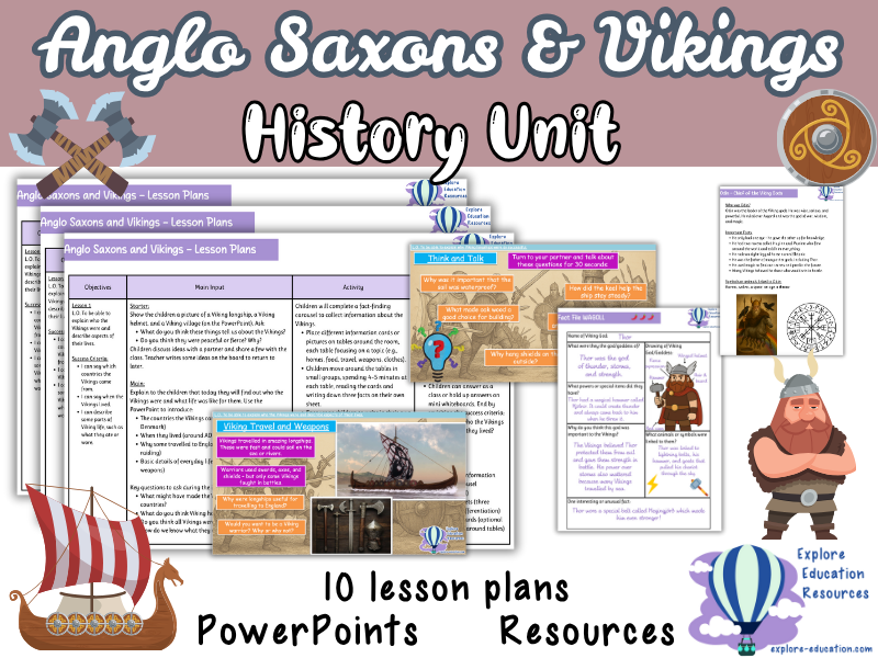
This KS2 history resource contains a full 10-lesson unit covering Viking and Anglo-Saxon life, raids, beliefs, and settlement in Britain. Suitable for Year 3 to Year 6, the unit includes lesson plans, activities, and PowerPoints designed to support pupils in understanding key historical events and daily life during this period.
Pupils will learn about Viking longships, Norse gods, the raid on Lindisfarne, Anglo-Saxon villages, and the reasons behind Viking migration and settlement. Lessons include opportunities for role play, poetry, drawing, and group discussion.
What’s included:
✔ 10 detailed lesson plans
✔ PowerPoint presentations for each lesson
✔ Differentiated worksheets and activity templates
✔ Vocabulary word banks and sentence starters
✔ Printable resources for games, quizzes, and poetry
✔ Links to child-friendly videos and websites
Lesson overview / structure:
★ Lesson 1 – Who Were the Vikings?
Fact-finding carousel on Viking origins, homes, food, and clothing. Includes a starter discussion and plenary quiz.
★ Lesson 2 – Viking Longships
Children label and design longships, learning about keels, sails, and shields. Includes video links and drawing activity.
★ Lesson 3 – Viking Traders and Settlers
Interactive trading game to understand Viking motivations for settling in England. Includes role cards and score sheets.
★ Lessons 4–5 – Lindisfarne Raid Poetry
Children write poems from both Viking and monk perspectives. Includes planning templates and vocabulary support.
★ Lessons 6–7 – Anglo-Saxon Daily Life
Research-based lessons with presentations or posters on Anglo-Saxon homes, jobs, food, and beliefs.
★ Lesson 8 – Viking Daily Life Research
Online research task with structured fact sheets and a carousel fact swap activity.
★ Lesson 9 – Viking Gods
Art and writing task focused on Odin, Thor, Freyja, and Loki. Includes fact files and drawing templates.
★ Lesson 10 – Viking Values Discussion
Open-ended discussion lesson using historical thinking questions. Includes group work and whole-class debate.
Why it’s useful:
✔ Fully differentiated activities for all abilities
✔ Includes creative tasks (poetry, drawing, role play)
✔ Supports historical enquiry and critical thinking
✔ Covers both Vikings and Anglo-Saxons in one unit
✔ Includes links to videos and safe research websites
Suggested use cases:
✔ KS2 history topic on Vikings and Anglo-Saxons
✔ Year 3–6 classroom teaching
✔ Whole-class discussion and group work
✔ Creative writing and cross-curricular literacy
✔ End-of-topic assessment or display work
Search tags:
KS2 history | Vikings and Anglo-Saxons | Viking longships | Lindisfarne raid | Norse gods KS2 | Anglo-Saxon village life | Year 5 history unit | Viking poetry | outstanding Viking lesson | KS2 trading game | Viking settlement lesson | Anglo-Saxon research task | Viking gods drawing activity | KS2 history planning
This Key Stage 2 geography unit includes eight fully planned lessons focusing on European landmarks, cultural similarities and differences, trade links, and environmental conditions. Pupils will develop geographical knowledge, map skills, data handling, and critical thinking through interactive activities and discussions.
What’s included:
✔ Eight detailed lesson plans covering objectives, activities, discussions, and outcomes
✔ Worksheets and tasks for map work, research, debate, and data analysis
✔ Activities such as travel brochure creation, planning travel adventures, and graphing climate data
✔ Opportunities for individual, group, and whole-class learning
Lesson overview / structure:
★ Lesson 1: Introduction to Europe – countries, geographical features, and significance
★ Lesson 2: European landmarks – location, historical and cultural importance, map activities
★ Lesson 3: Cultural similarities and differences – traditions, languages, and customs compared to local area
★ Lesson 4: Trade and travel connections – imports, exports, tourism, and geographical influences
★ Lesson 5: Planning a European travel adventure – itinerary building and research
★ Lesson 6: Expressing personal views about European locations – discussion and debate activities
★ Lesson 7: Geographical similarities and differences – comparing Spain with the local area
★ Lesson 8: Graphing and comparing geographical data – analysing temperature and rainfall patterns
Why it’s useful:
✔ Builds strong geographical knowledge and skills across KS2
✔ Supports critical thinking through discussions, comparisons, and evaluation
✔ Offers varied tasks to support different learning styles and abilities
✔ Encourages use of maps, graphs, and data in geography
✔ Ready-to-use lessons saving planning time
Suggested use cases:
Ideal for KS2 geography units on Europe, cross-curricular projects linking geography with English or maths skills, independent research tasks, and group discussions. Also suitable for revision and KS3 foundation lessons.
Search terms: KS2 Europe geography | European landmarks KS2 | KS2 cultural similarities | European environment KS2 | Key Stage 2 geography unit | KS2 geography lessons Europe | Spain UK comparison KS2 | KS2 map skills
Dive into the world of maps with this dynamic KS2 geography lesson on latitude and longitude, crafted for Years 3-6. This ready-to-teach resource delivers an engaging, curriculum-aligned experience that helps students master map skills and impresses in observations.
What You Get
Interactive PowerPoint with clear visuals to explain latitude, longitude, the Equator, and the Tropics
Hands-on worksheets, including map-labeling tasks and sentence-writing activities
Detailed lesson plan with step-by-step guidance, objectives, and differentiated tasks
Catchy video song to reinforce the difference between latitude and longitude
WAGOLL examples and sentence starters to support all learners
Full set of resources: starter task, world map activity, writing task, success criteria, word bank, and more
Learning Objectives
Distinguish between weather and climate
Label and explain the significance of latitude, longitude, the Equator, and the Tropics
Understand the direction and purpose of these lines
Describe country locations using latitude and longitude
Who It’s For
KS2 teachers (Years 3-6) teaching geography or map skills
NQTs or ECTs preparing for interview lessons or observations
Educators seeking Ofsted-ready, engaging geography resources
Why It Works
Proven in observations, meeting high teaching standards
Aligns with KS2 geography curriculum for locational knowledge
Keeps students engaged with varied tasks and a memorable song
Differentiates for all abilities, ensuring every learner succeeds
Saves prep time with all materials ready to use
Great For
Teaching latitude, longitude, and map skills in KS2
Delivering standout geography lessons for observations
Building confidence in navigating the world’s grid
Instant download. Fully editable. Ready to teach.
Tags
KS2 geography lesson, latitude and longitude, Years 3-6 map skills, weather and climate, Equator and Tropics, hemispheres, Earth’s grid, primary geography resources, Ofsted observation lesson, KS2 locational knowledge
Explore the impact of WWII with hands-on activities | Curriculum-aligned and teacher-friendly
Take your Year 3/4 students on a captivating journey through the impactful events of World War II with this comprehensive and ready-to-teach history unit. Explore key topics such as the Blitz, evacuation, rationing, and the life of Anne Frank, fostering empathy and understanding of this pivotal period in history.
What’s included:
✓ 5 weeks of detailed lessons, including objectives, activities, and extension ideas
✓ Interactive PowerPoints with historical photos, maps, and questions to engage students
✓ Creative activities like diary entries, biographies, and Blitz-themed art lessons
✓ Cross-curricular links to PSHE and citizenship for meaningful discussions
✓ Bonus: A ready-to-use Remembrance Day assembly script
Key Topics Covered:
★ Britain in the 1930s and the Outbreak of WWII
Students will learn about the events leading up to World War II and how Britain responded to the growing tensions.
★ The Blitz and Air Raid Shelters
Engage students with the story of the Blitz, exploring the devastating air raids and how people found safety in air raid shelters.
★ Evacuation Experiences
Explore the emotional and practical aspects of evacuation, allowing students to connect with the children who were sent away to safety during the war.
★ Rationing and Its Impact on Daily Life
Understand the difficulties faced during rationing and how families coped with limited supplies in wartime Britain.
★ The Life and Legacy of Anne Frank
Introduce students to Anne Frank’s story, encouraging them to reflect on her life and the impact of her legacy.
★ The End of the War and the Formation of the United Nations
Learn about the end of WWII and the creation of the United Nations as a result of the war’s devastation.
Why this resource stands out:
Curriculum-Aligned: Meets the national curriculum objectives for KS2 History.
Teacher-Friendly: Detailed lesson plans and ready-to-use resources save valuable prep time.
Student-Centered: Varied activities cater to different learning styles and encourage active participation.
Thought-Provoking: Encourages critical thinking and empathy through engaging discussions and creative tasks.
Ideal for:
KS2 History
Year 3 and Year 4 students
World War II topics
Cross-curricular links to PSHE and Citizenship
Remembrance Day activities
Search terms: KS2 History, WWII, World War II, Blitz, evacuation, rationing, Anne Frank, Remembrance Day, British history, 20th-century history, year 3, year 4, curriculum, interactive lessons, creative activities, World War 2
Explore iconic sites across Europe | Includes map work, planning tasks and visuals
This fully resourced Europe Geography lesson focuses on famous landmarks such as the Eiffel Tower, Big Ben, the Colosseum, and more—helping pupils build their map skills, cultural awareness and historical understanding in a fun and engaging way.
Perfect for KS2 geography or humanities, this lesson is ideal for supporting your Europe topic or for standalone use as part of cross-curricular learning.
What’s included:
✔ PowerPoint presentation with photos and facts about key European landmarks
✔ Blank maps for pupils to locate and label each landmark
✔ Travel brochure-style templates for a creative planning activity
✔ Visual reference cards for class display or group work
✔ Differentiated writing prompts to support a range of learners
Lesson activities:
★ Landmark matching and description task
★ Map marking to locate landmarks across Europe
★ “Plan a European adventure” activity using the travel brochure template
★ Whole-class discussion on how landmarks reflect cultural and historical identity
Why teachers love it:
✔ Encourages curiosity about European history and culture
✔ Builds geography skills in a real-world context
✔ Supports creative writing and persuasive language in cross-curricular tasks
✔ Fully resourced and easy to deliver – ideal for lessons or themed weeks
Perfect for:
KS2 Geography and Humanities
European studies or cultural awareness units
Travel and tourism-themed writing
Display work and project-based learning
Group or individual tasks
Search terms: European landmarks lesson | Europe geography KS2 | KS2 map work | famous places in Europe | Eiffel Tower Big Ben Colosseum lesson | Year 5 geography | travel and tourism KS2 | cultural landmarks activity outstanding lesson
A complete geography lesson focused on map skills, including compass directions, grid references, and map symbols. Ideal for KS2 students.
In this lesson, students will learn to use compass directions, 4-figure grid references, symbols, and map keys to navigate and explore Europe. The resource includes detailed activities that support students in developing essential map-reading skills while deepening their understanding of European geography.
What’s included:
✔ 23-slide PowerPoint presentation
✔ Europe maps
✔ Activity sheets
✔ Symbols key
✔ Compass (optional)
✔ Answers for activities
Lesson overview / structure:
★ Starter – Discussion on compass directions and grid references in map exploration
★ Main activity 1 – Labeling the 8 compass points and practising giving directions to countries/cities in Europe
★ Main activity 2 – Using 4-figure grid references to locate points and identify corresponding countries or cities
★ Main activity 3 – Group activity where students place symbol cards on a large map of Europe
★ Plenary – Review concepts covered and share knowledge by identifying countries, cities, and geographical features on the map
Why it’s useful:
✔ Supports map-reading and navigation skills
✔ Encourages teamwork and collaboration
✔ Differentiated activities to support various learning styles
✔ Engaging and interactive
✔ Ready-to-use resources save lesson planning time
Suggested use cases:
Ideal for KS2 geography lessons on Europe, map skills, compass directions, grid references, and understanding map symbols. Perfect for introducing European geography and map-reading exercises.
Search tags: KS2 geography | Europe map skills | compass directions | grid references | map symbols | European geography | Year 3 geography | Year 4 geography | map-reading activities | geography lesson plans | interactive geography | map activities
Fully resourced | Ideal for global learning, cultural exploration, and cross-curricular lessons
Take your class on a virtual journey through France with this exciting 5-lesson unit, designed to bring French geography, culture, and lifestyle to life. Packed with engaging content and cross-curricular links, this unit is ideal for Year 3 to Year 6 students, perfect for the summer term, culture weeks, or global learning topics.
This comprehensive resource provides everything you need, including fully planned lessons with PowerPoints, worksheets, activities, and assessments. It’s curriculum-linked, requiring no additional planning – simply pick up and teach!
What’s Included:
x5 Lesson Plans: Detailed, step-by-step plans for each lesson, with clear learning objectives and success criteria.
x5 PowerPoints: Engaging slides for each lesson, featuring maps, pictures, and interactive content.
Worksheets & Activities: Differentiated worksheets to cater to different learning needs, including activities that focus on French landmarks, culture, and geography.
Assessments: Simple assessments to measure understanding and progress throughout the unit.
Key Learning Outcomes:
French Geography: Learn about the key geographical features of France, including regions, rivers, and landmarks.
Comparisons Between France and the UK: Compare French geography and lifestyle with that of the UK using maps, data, and discussions.
Cultural Exploration: Understand key aspects of French culture, including food, lifestyle, festivals, and traditions.
Cross-Curricular Connections: Integrate geography with language, history, and culture, fostering a deeper understanding of the world.
Lesson Overview:
Lesson 1: Introduction to French geography – regions, rivers, and landmarks.
Lesson 2: Comparing France with the UK using maps and data.
Lesson 3: Exploring French culture – food, festivals, and traditions.
Lesson 4: Famous places in France – Paris, the Eiffel Tower, and more.
Lesson 5: French lifestyle and how it differs from British life.
Why Choose This Resource?
Curriculum-Aligned: Fully supports the KS2 geography curriculum with a focus on global learning and cultural exploration.
Ready to Teach: Fully planned lessons with everything you need, including PowerPoints and differentiated resources.
Engaging and Informative: A fun and interactive way to explore French geography and culture, ideal for the summer term or a culture week.
Cross-Curricular: Links geography with other subjects such as history, language, and global citizenship.
Ideal For: KS2 Geography, Year 3, Year 4, Year 5, Year 6, French Culture, French Landmarks, Summer Term Geography, Geography Assessment, Global Learning, Cross-Curricular Geography.
Enhance your Key Stage 2 curriculum with our outstanding Rainforest Unit - a comprehensive set of six engaging geography lessons meticulously designed to foster an in-depth understanding of rainforests. This resource is a valuable addition to your teaching toolkit, complete with detailed lesson plans, informative PowerPoints, and student-focused worksheets.
Lesson 1: Rainforest Regions and Significance
In this lesson, students will identify the continents hosting rainforests, label a world map with major rainforest regions, and grasp the significance of rainforests for Earth’s biodiversity. The lesson starts with an intriguing Rainforest Wonder Box activity, setting the tone for exploration.
Lesson 2: Rainforest Climate and Adaptations
Students will explore the climate characteristics of rainforests, understand why they are called “rainforests,” and identify adaptations of animals and plants. The lesson fosters critical thinking and understanding of how species thrive in rainforest conditions.
Lesson 3: Layers of the Rainforest
This lesson delves into the various layers of the rainforest, highlighting the unique organisms that inhabit each layer. Students will create engaging visual representations of rainforest layers, enhancing their knowledge of the intricate ecosystems.
Lesson 4: Rainforest Animals and Plants
Students will categorize and differentiate between rainforest animals and plants, gaining insights into the rich diversity of rainforest life. Engaging activities, including “Categorising Organisms” and “Rainforest Habitat Diorama,” deepen their comprehension.
Lesson 5: Amazon Rainforest vs. UK Forest
Comparing the Amazon rainforest and a UK forest, students will identify differences and similarities, understand biodiversity, and explore the importance of these ecosystems. The lesson encourages critical thinking and insightful discussions.
Lesson 6: Rainforest Conservation and Action
In the final lesson, students will comprehend the significance of rainforest conservation and discover ways to contribute. Engaging activities like creating conservation posters or slogans empower students to express their commitment to preserving these vital environments.
Our unit equips educators with everything needed for an engaging rainforest unit, including PowerPoint presentations, visual aids, worksheets, and hands-on activities. Promote geographical understanding, critical thinking, and environmental awareness with our Rainforest Unit.
Have any issues with this resource or a request? Contact us directly for the quickest response at: explore_education@outlook.com
Tags: Key Stage 2, Geography, Rainforest, Biodiversity, Conservation, Ecosystem, Climate, Adaptations, Critical Thinking, Interactive, Engaging, Curriculum, Lesson Plans, PowerPoints, Worksheets, interview, ofsted, observation
Fully resourced for hands-on learning and map skills | Ideal for 60-minute lessons
This engaging and educational KS2 geography lesson focuses on compass directions, helping students understand both cardinal and intercardinal points while encouraging practical map-reading skills. The resource includes a well-structured lesson plan, a visually engaging PowerPoint presentation, and interactive activity sheets that guide students in applying their knowledge of compass directions to map reading and writing directions.
What’s included:
✔ A comprehensive lesson plan to ensure a smooth and impactful teaching experience
✔ A PowerPoint presentation that introduces and reinforces compass directions
✔ Interactive activity sheets that support students in applying their knowledge to real-world map reading and direction writing
✔ Practical activities where students use compass skills to create written directions for a journey
✔ Extension tasks for early finishers, offering additional challenges to deepen understanding
Skills and knowledge covered:
Cardinal and Intercardinal Directions: Understanding the basic compass points (north, south, east, west) and their intercardinal counterparts (northeast, southeast, northwest, southwest)
Map Reading: Developing map-reading skills by using compass directions to follow and write directions
Practical Application: Writing directions for a journey based on map reading
Extension Activity: Providing a challenge for early finishers to extend their learning of compass directions
Why this lesson stands out:
✔ Offers an interactive, hands-on approach to learning compass directions
✔ Supports the development of map-reading and spatial awareness skills
✔ Adaptable to different ability levels and lesson durations
✔ Ready-to-use with minimal preparation, perfect for busy teachers or observation lessons
✔ Combines theoretical knowledge with practical application for a well-rounded learning experience
Perfect for:
KS2 geography lessons on compass directions
Teaching map skills and spatial awareness
Cross-curricular activities involving geography and literacy
Observation or interview lessons
Geography mastery-style teaching
Search terms:
KS2 geography lesson | compass directions lesson | map reading KS2 | cardinal and intercardinal directions | geography lesson plans | direction writing | KS2 geography activities | compass skills lesson
Fully resourced for inquiry, creativity, and historical thinking | Ideal for Years 3–6 and Ofsted observations
Immerse your class in the fascinating world of the Bronze Age with this set of three high-quality history lessons. Designed for KS2 pupils, this unit supports chronological understanding, critical thinking, and engagement with historical evidence.
What’s included:
✔ 3 detailed lesson plans with clear learning objectives
✔ PowerPoints, activity sheets, fact files and visual resources
✔ High-quality images of artefacts and engaging video content
✔ Differentiated and creative tasks to support all learners
Lesson overview:
1. Unveiling the Bronze Age
Explore where the Bronze Age fits in the historical timeline and why it was a turning point. Pupils learn about the discovery of bronze and its impact on tools, trade, and daily life.
2. Life in the Bronze Age
Step into the shoes of people from the past with a focus on daily life, customs, and notable archaeological finds. Pupils learn about Marghwen’s cist and the Amesbury Archer, using artistic responses to connect with history.
3. Evidence from the Past
Develop historical skills by examining and categorising artefacts from the Stone, Bronze, and Iron Ages. Pupils investigate jewellery and create a Bronze Age fact file based on real evidence.
Why this unit stands out:
✔ Encourages critical thinking through artefact-based learning
✔ Combines discussion, visual resources, and creative expression
✔ Fully adaptable for different ability levels and teaching contexts
✔ Minimal prep required – ready-to-teach resources
Perfect for:
KS2 history lessons (Y3–Y6)
Chronology and prehistory units
Cross-curricular links with literacy and art
Ofsted observations or interview lessons
Search terms: KS2 Bronze Age | Year 3–6 history planning | Bronze Age artefacts lesson | Amesbury Archer resource | prehistoric Britain | outstanding history lessons | primary history inquiry | Marghwen cist discovery
Outstanding geography lesson with map skills, climate comparisons and travel challenges
This engaging and fully resourced Europe geography lesson focuses on latitude, hemispheres, time zones and climate, helping pupils understand how these key geographical features shape life and travel across the continent.
Designed for KS2 and lower KS3, this lesson develops pupils’ knowledge of global and European geography through practical tasks, map work and real-world challenges. Ideal for observations, interviews or curriculum teaching.
What’s included:
✔ A detailed lesson plan with learning objectives and plenary prompts
✔ Editable PowerPoint presentation to guide the session
✔ Printable maps for labelling activity
✔ Climate charts for interpretation and discussion
✔ Time zone travel challenge worksheet
✔ Interactive trivia quiz cards for plenary review
Lesson activities:
★ Map labelling – Locate the Equator, hemispheres, and key regions in Europe and globally
★ Climate analysis – Compare seasonal patterns across European locations using real data
★ Time zone challenge – Calculate arrival times and travel differences using a map-based task
★ Trivia quiz – Reinforce key learning in a fun, interactive class game
Why teachers love it:
✔ Covers essential knowledge in a real-world context
✔ Promotes map reading, data handling, and critical thinking
✔ Great mix of visual, practical and discussion-based learning
✔ Easily adaptable for Years 3–6 and lower KS3
✔ Ideal for Ofsted lessons, interviews or high-quality classroom teaching
Perfect for:
KS2/KS3 Geography (Years 3–6, Year 7)
Map skills and climate topics
Cross-curricular links with maths (time and data handling)
European studies and global location units
Whole-class or group learning
Search terms: KS2 Europe geography | time zones and travel | equator and hemispheres lesson | climate zones KS2 | map skills year 5 | outstanding geography lesson | ofsted interview lesson | world geography year 6 | longitude and latitude KS2
Fully resourced for History, Geography, and Humanities | Ideal for flexible half-term planning or stand-alone lessons
This complete Ancient Egypt unit is designed to bring history to life for your students, covering key topics such as the geography of Egypt, the importance of the River Nile, Ancient Egyptian society, the pyramids, and hieroglyphics.
The seven lessons are structured to be used in any order and provide a comprehensive exploration of Ancient Egypt, with detailed lesson plans, engaging PowerPoints, and ready-to-use worksheets. These resources are ideal for a half-term of teaching and can be easily adapted for different abilities.
Included Resources:
7 detailed lesson plans
7 interactive PowerPoints
Blank world map
Blank timeline
Building images for timeline
Picture clue sheet
Timeline events
Blank map of Egypt
Guidance sheet for Ancient Egyptian society activity
Questions for an Ancient Egyptian slave
Hieroglyphic alphabet
3 differentiated Mummification worksheets
Egyptian number system
Egyptian maths workbook
Hook ideas
Key Topics Covered:
Locating Egypt on a world map and its position on a timeline
The importance of the River Nile to Ancient Egyptians
The hierarchy of Ancient Egyptian society and pyramid construction
The significance of the pyramids at Giza
Introduction to hieroglyphics and their use in Ancient Egypt
The process of mummification
Why This Resource Stands Out:
Expertly Designed: Created by a Geography and History subject lead with classroom-tested resources.
Curriculum-Aligned: Meets KS2 Geography and History curriculum objectives.
Differentiated Activities: Includes activities for various learning styles and abilities, ensuring accessibility for all students.
Comprehensive Coverage: Fully resourced with PowerPoints, worksheets, and extension tasks to deepen understanding.
Flexible & Easy to Use: Suitable for both standalone lessons or a full half-term unit, with ready-to-go resources.
Ideal For: KS2 History, Year 3, Year 4, Year 5, Year 6, Ancient Egypt, History, Geography, Humanities, Ofsted inspections, SEN, LA, MA, HA, remote learning.
Bring the power of tornadoes to your classroom with this hands-on KS2 geography lesson, perfect for Years 3-6. Using simple materials, this engaging, curriculum-aligned resource helps students understand how tornadoes form while delivering a memorable lesson that stands out in observations.
What You Get
Detailed lesson plan with clear objectives and success criteria
Engaging PowerPoint to guide the lesson with vivid visuals
Worksheets, word bank, and extension task for varied activities
Pictures of the “tornado in a cup” experiment
Plenary ideas to wrap up learning
Learning Objectives
Understand what a tornado is and how it forms
Create a tornado in a glass using lemonade and salt
Explain tornado formation based on the practical task
Develop quiz-style questions using tornado facts from class resources
Who It’s For
KS2 teachers (Years 3-6) teaching geography, weather, or climate
NQTs or ECTs preparing for Ofsted or interview lessons
Educators seeking practical, observation-ready geography resources
Why It Works
Captivates students with a hands-on tornado experiment
Aligns with KS2 geography curriculum on weather and extreme Earth
Differentiates learning with worksheets, word banks, and extensions
Saves prep time with all materials included and easy-to-source items
Proven to impress in Ofsted observations
Great For
Teaching tornadoes and extreme weather in KS2
Delivering interactive geography lessons for observations
Engaging students in hands-on learning about climate
Instant download. Fully editable. Ready to teach.
Tags
KS2 tornadoes lesson, Years 3-6 geography, extreme weather, tornado facts, KS2 climate lessons, hands-on geography, Ofsted observation resource, primary teaching resources, weather and climate, tornado experiment, KS2 humanities
Explore European geography and culture using maps, atlases, globes and digital tools
This fully resourced KS2 geography lesson supports pupils in identifying and describing European countries and their unique characteristics. Ideal for observations, interviews, or as part of a wider Europe topic, this lesson encourages pupils to use a range of mapping tools while developing their understanding of landscapes, languages, culture and landmarks.
Designed for Year 3 and upwards, this engaging session promotes curiosity, geographical awareness and key map skills.
What’s included:
✔ A detailed lesson plan with clear objectives and assessment ideas
✔ PowerPoint presentation to guide input and activities
✔ Printable maps for country identification and labelling
✔ Access to digital maps and tools for interactive tasks
✔ Suggestions for using atlases and globes in class
Lesson activities:
★ Starter task – Identify and label European countries on a blank map
★ Main input – Explore features of different countries using maps and images
★ Activity options – Locate key geographical features, describe countries’ characteristics, and complete interactive mapping tasks
★ Assessment – Based on map accuracy, participation in discussion, and understanding of cultural features
Why this lesson works well:
✔ Encourages map reading, critical thinking and group work
✔ Links physical and human geography in a meaningful way
✔ Supports digital and practical resource use in the classroom
✔ Easy to adapt for different year groups or time frames
✔ Great for building discussion and presentation skills
Perfect for:
Year 3–6 geography lessons
European studies or cultural awareness topics
Map skills and location knowledge
Observation or interview lessons
Cross-curricular links with history and language
Search terms: Europe geography KS2 | locating European countries | year 3 geography | outstanding interview lesson | map work KS2 | cultural geography Europe | digital maps and globes | lesson plan and PowerPoint KS2 | geography observation lesson
Fully resourced for map skills, classification, and geographical understanding | Ideal for 30–60 minute lessons
This outstanding-rated Key Stage 2 geography lesson focuses on identifying and differentiating between human and physical geographical features, offering an interactive and engaging way to explore maps and geographical concepts.
Designed for KS2 students, this flexible session can be used in a 30-minute or 1-hour format, making it perfect for regular geography lessons, Ofsted observations, or NQT interview lessons.
What’s included:
✔ A clear and structured PowerPoint presentation to guide the lesson
✔ Activity sheets for hands-on learning, including map identification tasks
✔ Extension activities, including a task on map features of London using compass points
✔ Focus on key skills:
Identifying human and physical features on a map
Comparing and classifying geographical features
Creating and labelling maps with identified features
Why this lesson stands out:
✔ Combines map skills, classification, and practical application
✔ Supports understanding of geographical features and their differences
✔ Adaptable for different abilities and lesson timings
✔ Ready-to-use with minimal prep – ideal for busy teachers and formal observations
Perfect for:
KS2 geography lessons
Map skills and geographical features units
Intervention groups and booster sessions
Ofsted observation lessons
NQT interview lessons
Search terms: KS2 human and physical features | map skills geography | Year 6 geography lesson | KS2 map features | London map extension activity | geographical classification | KS2 geography observation | compass points activities
This lesson focuses on the layers of the rainforest, perfect for engaging Year 3-6 students in learning about rainforest habitats, animal and plant adaptations, and the unique characteristics of each layer. The resource is designed to provide a comprehensive and interactive experience for pupils to explore this fascinating topic.
What’s Included:
✔ Lesson plan with clear learning objectives and a step-by-step guide
✔ Interactive PowerPoint to support visual learning and discussion
✔ Rainforest fact cards for plenary activity and independent research
✔ Differentiated worksheets, including labeling, descriptive writing, and fill-in-the-blanks activities
✔ Answer sheet for quick assessments and feedback
Lesson Overview / Structure:
★ Starter
Introduce the four layers of the rainforest with a brief overview and interactive questions.
★ Main Activity
Use the PowerPoint to explore each layer’s characteristics, and engage students with the worksheets for hands-on learning.
★ Plenary
Reinforce learning with the rainforest fact cards, encouraging independent research and class discussion.
Why It’s Useful:
✔ Curriculum-aligned with KS2 science on living things and their habitats
✔ Differentiated worksheets to cater to all abilities
✔ Includes everything needed for a complete lesson, saving time on preparation
✔ Designed by a teacher with years of classroom experience
Suggested Use Cases:
Ideal for KS2 science lessons, Year 3-6 students studying habitats, rainforest ecosystems, animal and plant adaptations, and environmental investigations.
Search Tags:
KS2 science | rainforest layers lesson | Year 3 geography | rainforest adaptations | KS2 habitats | living things science | outstanding KS2 geography lesson
This free EYFS reading sheet introduces rainforest-themed sight words to support early vocabulary development and reading skills. Designed for children aged 3–5, each word is paired with a clear illustration of a rainforest animal, plant, or insect to provide visual context and aid recognition.
What’s included:
✔ 1 printable rainforest sight word sheet
✔ Colourful illustrations to support understanding
✔ A variety of rainforest-themed words for early readers
How the resource is structured:
★ The sheet displays themed sight words in a clear, accessible format
★ Each word is supported by a matching image to help with comprehension
★ Can be used for matching games, vocabulary discussions, or display
Why it’s useful:
✔ Supports word recognition and topic vocabulary
✔ Reinforces cross-curricular learning with a rainforest theme
✔ Suitable for independent or group activities
✔ Easy to print and reuse across settings
Suggested use cases:
Perfect for EYFS classrooms, themed vocabulary work, continuous provision, or early reading practice linked to a rainforest topic.
Search tags: EYFS reading | rainforest vocabulary | sight word sheet | Reception literacy | early reading EYFS | rainforest animals | EYFS topic words | themed vocabulary sheet
This free lesson is an excellent starting point for a topic on mountains, ideal for kicking off a geography unit on continents or focusing on mountain ranges worldwide. It provides a strong foundation for children to explore geographical features and their locations on the globe.
What’s included:
✔ Lesson plan
✔ PowerPoint to guide the lesson
✔ KWL Grid to assess prior knowledge
✔ Mountains Table Template
✔ Previous Knowledge worksheet
✔ World Map for labelling
Learning Objective (L.O.):
To be able to locate mountains in different continents.
Success Criteria:
✸ I can write facts about mountains.
✸ I can name the seven continents of the world.
✸ I can think of questions I want to know the answer to.
✸ I can identify mountain ranges on maps.
Perfect for:
Year 3, 4, 5, and 6
Geography lessons on mountains, continents, and physical features
Using atlases (including Google Earth) to explore mountain ranges
Creating an interactive learning experience for children with a focus on world maps
Search terms: geography lesson KS2 | mountains lesson KS2 | world maps for children | atlases KS2 | mountain ranges geography | continents geography lesson