Lesson 6 for Topic 8 looks at how the nutrient cycle operates within the Taiga biome. Processes are draw, described and explained with a clear link to climate. Food webs and chains are explored before a look at biodiversity.
Lesson 4 for Topic 8 which looks at the final part for the TRF. Conservation is explored through global groups (REDD and CITES) before looking at local methods of conservation through afforestation etc. Pupils decide which one is more effective for saving the rainforest.
A resource looking at flags - which all kids love in geography! There is an activity re-capping urban and rural followed by a flag Powerpoint quiz. There is an activity to get kids engaged and designing their own flag. The importance of flags is also considered.
A lesson looking at Peru - Gap Year travel or general geography e.g. volcanic activity, Machu Picchu, Nazca lines and volunteering opportunities in the Jungle. Lots of opportunities for a carousel activity or for pupils to plan a trip to Peru/advertise a poster?
A lesson that re-caps direction but also look at at map symbols - why they are important, most common map symbols and a quiz. Pupils look at the most relevant ones and evaluate the best map symbols. Pupils write a story and can complete a word search!
OCR B GCSE lesson looking at the physical and human causes of development being affected, Rostow’s stages of development and different types of aid
Link to Topic 6 (Development Dynamics) from the specification
Applicable for all exam boards - mainly for OCR B (Physical Landscapes - Coastal Landscapes) looking at erosional landforms at the coast - platforms, headlands & bays and stump formation
Mainly for OCR B GCSE but can be adapted for KS3 - a lesson looking at climate change impacts with a focus on social, economic and environmental aspects from a UK and worldwide perspective!
A KS4 lesson for year 10/11 (can be used for KS3 and adapted) looking at River landforms linked to OCR B Specification (Topic 3) as well as Edexcel B (Topic 4)
The lesson looks at intro to rivers, river profile, nad the main landforms found in the upper course of a river - v-shaped valley and waterfalls.
A lesson aimed at GCSE pupils but can be used for KS3 - looking at features and landforms within the middle course of a river - meanders and ox-bow lakes - as well as lower course features such as levees and floodplains.
Mainly for OCR B and EDEXCEL
Outstanding rated interview lesson on impacts of urbanisation - worksheet included and issues/solutions such as traffic and public transports. Complete with extension and challenge tasks as well as a plenary.
A Year 8 lesson looking at the impacts of industrial UK change over time - impacts on cities such as Sheffield and Glasgow. Outstanding-rated lesson by Ofsted with all resources.
Introduction lesson to Disease Dilemma topic (Paper 3 debates) for OCR A LEVEL GEOGRAPHY. Includes the main element around classification of diseases and different types.
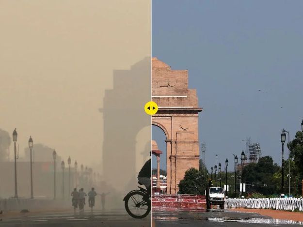
An A-level lesson for OCR B GEOGRAPHY looking at Disease Dilemma topic - Air pollution in India case study - can be used for other year groups. Focuses on skills for location, causes and impacts of air pollution and the impact on lung cancer.
A lesson for A-Level OCR B Geography - Disease Dilemma topic looking at the outbreak of disease due to a natural hazard. This lesson looks at the Haiti 2010 earthquake and outbreak of Cholera