SPANISH-SPEAKING COUNTRIES BEGINNER SPANISH INTERMEDIATE SPANISH ADVANCED SPANISH KS4 SPANISH GCSE SPANISH KS5 SPANISH A LEVEL SPANISH SPANISH-SPEAKING COUNTRIES, CAPITALS AND FLAGS WORKSHEETS
Files are non-editable in a zipped format. This product is copyright, all rights reserved. It is illegal to copy, rewrite, amend, share or distribute outside your own classroom in any way. The license for purchase is a single-user license only. School / departmental licenses are available. Please read the Terms of Use carefully.
Ideal for cross-curricular learning: Spanish and geography, suitable for any age range, at any time of the school year, and particularly at the beginning of a Spanish learning programme. Students can develop their knowledge of the geography and scope of Spanish-speaking countries in a cooperative, communicative and interactive way, independently of the teacher.
The set contains countries / territories where Spanish is an official language. There are 7 differentiated worksheets, and an alphabetical reference list featuring countries, capital cities, continent and national flag, which works both as a long-term reference resource and an answer key. The differentiated challenges ensure students will really embed and consolidate their knowledge of Los países hispanohablantes.
= Worksheet 1: flags are in colour, students label continent, country and capital city.
= Worksheet 2: flags are BW, students colour the flags appropriately, label continent, country and capital city.
= Worksheet 3: flags are in colour, students label continent and capital city from a country / flag prompt.
= Worksheet 4: the same as 3, with additional challenge of colouring the BW flags appropriately
= Worksheet 5: flags are in colour, students label country from a flag / continent / capital prompt.
= Worksheet 6: the same as 5, with additional challenge of colouring the BW flags appropriately from a flag / continent / capital prompt.
= Worksheet 7: blank flags, which student recreate according to country, also labelling continent and capital city
The Lively Learning Classroom offers a wide range of Spanish resources, including special offer bundles and freebies.
¡MUCHAS GRACIAS Y BUEN VIAJE!
EUROPEAN DAY OF LANGUAGES EUROPE QUIZ - IDEAL FOR UPPER KS4 / KS5 STUDENTS
The resource is non-editable in a zipped format. It may not be copied, rewritten, shared or distributed outside your own classroom in any way. The license for purchase is a single-user license only. Please read the Terms of Use carefully.
This European Day of Languages quiz focuses on a range of topics and themes about Europe. Students can broaden and develop their knowledge of Europe in a cooperative, communicative and interactive way, independently of the teacher. The quizzes work well as a whole-group team quiz, and are also perfect for pair or small-group activities.
The quizzes are for older students, who have a more developed understanding, knowledge and awareness of the world. Some responses will be generally well-known to students, others less so, as the questions range from basic general knowledge to more specialized factual knowledge. This ensures that the activity is equally about reflecting on what students know, as it is about what they can learn. In this way, the quizzes aim not only to consolidate existing knowledge, but also to enable students to learn more about Europe. The questions and answers also provide a comprehensive framework for further exploration of Europe, which both broadens and enriches the learning experience.
I generally give students multiple opportunities over the school year to play the quizzes, not just on or around the European Day of Languages. Before we play, I always screen a clear map of Europe, to ensure that students can visualize it in its entirety, the location of individual countries within it, and in relation to each other. This provides an important learning context for students. The quiz opens with general questions about Europe, and then moves on to questions about a range of individual European countries.
There are 80 questions across two challenges:
Challenge 1: 56 multiple-choice questions, with four response options to choose from. The correct response is in capital letters.
Challenge 2: 24 questions in TRUE / FALSE format. Where the answer is false, students should additionally give the correct response.
The questions address and topics such as: music and the Arts; daily life; famous figures; geography; history; landmarks; language and linguistics; literature; politics; science; social history; society
This is the General Knowledge Europe Quiz edition of the European Day of Languages Europe Quiz #2 - please ensure you haven’t already purchased that edition.
Laminate the cards if you can - they are easier to manipulate, and remain in excellent condition for years.
Have a browse in my store for more European Day of Languages activities and resources!
THANKS AND HAVE A GREAT EUROPEAN DAY OF LANGUAGES!
EUROPEAN DAYS OF LANGUAGES QUIZ EUROPEAN COUNTRIES AND CAPITAL CITIES - 2 QUIZZES WITH 120 MULTIPLE-CHOICE QUESTIONS
Files are non-editable in a zipped format. This product is copyright, all rights reserved. It is illegal to copy, rewrite, amend, share or distribute outside your own classroom in any way. The license for purchase is a single-user license only. School / departmental licenses are available. Please read the Terms of Use carefully.
Ideal multiple-choice quizzes for the European Day of Languages. Students can develop their knowledge of Europe in a cooperative, communicative and interactive way, independently of the teacher. Play both as a whole-group team quiz, or in pairs / small groups on a regular basis - students are particularly keen to see if they can beat their own points record, and are really motivated by their developing knowledge.
The set contains all European countries and capital cities, including some island communities such as the Faroe Islands and Guernsey. Each question has 4 answers to choose from. The correct answer is given in capital letters. The quiz cards are numbered, but questions can be asked in random order too: simply place all the cards in a bowl, box or tin, and work your way through.
There are two quiz challenges:
= Challenge 1gives the country as a prompt, with four possible capital cities to choose from.
= Challenge 2 gives the capital city as a prompt, with four possible countries to choose from.
The card numbers for Challenge 1 are in the top right-hand corner; Challenge 2 in the top left-hand corner so that the cards can be organised and sorted easily. Laminate the cards if possible: they’re more learner-friendly, and remain in excellent condition for years.
Please note this is the European Day of Languages Europe Countries & Capitals quizzes edition of our Geography Europe Countries & Capitals quizzes - please ensure you have not already purchased the Geography edition.
Before playing, it’s useful to show students a clear map of Europe, so that they can visualise the location of each country and capital city, not only as an individual location with Europe, but also as a location in relation to other European countries and capital cities. This definitely helps students understand and memorise the countries and capital cities.
The Lively Learning Classroom has a wide range of resources for the European Day of Languages, including special offer bundles and freebies.
THANK YOU AND ENJOY THE EUROPEAN DAY OF LANGUAGES!
KS4 GEOGRAPHY KS3 GEOGRAPHY USA STATES AND STATE CAPITALS GEOGRAPHY AMERICAN STATES AND CAPITALS FOUR MULTIPLE-CHOICE QUIZZES
***Files are non-editable in a zipped format. The product is copyright, all rights reserved. It may not be copied, rewritten, shared or distributed outside your own classroom in any way. The license is a single-user licence only. Please read the Terms of Use. ***
Perfect for geography class, as well as a general knowledge quiz: an ideal way for students to learn and test their knowledge of the states and capitals of the USA. There are four multiple choice quizzes, each question with four possible answers to choose from, 160 individual questions in total. The correct answer is given in capital letters.
The quizzes work well as a whole, small-group or paired oral quiz. Each quiz card is numbered in a particular place according to the particular quiz, so that the cards can be easily sorted and organised before and after playing. Laminate if you can - it’s definitely worth the extra prep time and expense, as they cards are more learner-friendly and remain in excellent condition for years, so you’ll get lots of use from them.
Quiz Challenge 1: The capital of… is… (4 choices, 50 questions)
Quiz Challenge 2: … is the capital of… (4 choices, 50 questions)
Quiz Challenge 3: True or false: The capital of… is… (4 choices, 30 questions) - where the answer is false, students should also give the correct answer
Quiz Challenge 4: True or false: … is the capital of… (4 choices, 30 questions) - where the answer is false, students should also give the correct answer
Have a browse in my store for more Geography resources, including special offer bundles and freebies.
THANK YOU AND ENJOY THE QUIZZES!
EUROPEAN DAY OF LANGUAGES FOLLOW ME GAME EUROPEAN DAY OF LANGUAGES EUROPE COUNTRIES AND FLAGS I HAVE, WHO HAS? GAME
Files are non-editable in a zipped format. This product is copyright, all rights reserved. It is illegal to copy, rewrite, amend, share or distribute outside your own classroom in any way. The license for purchase is a single-user license only. School / departmental licenses are available. Please read the Terms of Use carefully.
Ideal whole-group communicative game for the European Day of Languages. The repetitive nature of the questions and answers, supported by the visual prompt of the flags, makes it perfect for learning the countries of Europe and their national flags.
The aim of the game is to make an alphabetical country line as quickly as possible, starting with the first card, Albania, and ending with the final card, Wales. Students will probably have several cards each, depending on the size of your group. Playing in teams against a timer adds a very popular competitive edge, and you will need a couple of sets of cards, depending on the size of your group. Start with a rapid whole-group warm-up, asking questions such as How many European countries can you name in 15 seconds? and so on.
Laminate the cards if you can, as they are more learner-friendly, and remain in excellent condition for years, so you’ll get lots of use from them. There are six cards per A4 (8.5x11) landscape, 60 cards in total.
The Lively Learning Classroom has a wide range of resources for the European Day of Languages activities, including special offer bundles and freebies.
THANKS AND HAVE A GREAT EUROPEAN DAY OF LANGUAGES!
EUROPEAN DAYS OF LANGUAGES EUROPE COUNTRIES, CAPITAL CITIES AND FLAGS POSTERS / FLASHCARDS
Files are non-editable in a zipped format. This product is copyright, all rights reserved. It is illegal to copy, rewrite, amend, share or distribute outside your own classroom in any way. The license for purchase is a single-user license only. School / departmental licenses are available. Please read the Terms of Use carefully.
Ideal for the European Day of Languages - an instant and comprehensive introduction to Europe , perfect for developing knowledge of European countries, capital cities and national flags.
This kind of classroom display provides a real learning opportunity during September, in the run-up to, and on the European Day of Languages. There may be a number of countries and capital cities that students do not know, or are not aware of, so the posters help students develop their general awareness, knowledge and understanding of Europe. It’s useful to show students a clear map of Europe, so that they can visualise the location of each country and capital city, not only as an individual location with Europe, but also as a location in relation to other European countries and capital cities.
There is a range of islands, such as the Faroe Islands, and also some countries, for example Armenia, that are often classed as belonging either to Europe or to Asia. Some countries have two posters, such as Greece, officially known as the Hellenic Republic - you can choose either the more frequently-used Greece or the Hellenic Republic to display.
This is the European Day of Languages edition of our Geography Europe posters: please ensure you have not already purchased that set.
There are two formats to choose from - Europe map background or plain without frame, which keeps prep costs at a minimum. Laminate if you can, even though it’s extra prep time and expense. The posters display better, as flashcards they’re a lot easier to manipulate, and they do remain in excellent condition for years, so you’ll be able to recycle them many times.
The Lively Learning Classroom has a wide range of European Day of Languages resources, including special offer bundles and freebies.
THANKS AND HAVE A GREAT EUROPEAN DAY OF LANGUAGES!
KS3 SPANISH KS4 SPANISH KS5 SPANISH BEGINNER SPANISH INTERMEDIATE SPANISH CROSS-CURRICULAR LEARNING SPANISH AND GEOGRAPHY EUROPE : EUROPEAN COUNTRIES, CAPITAL CITIES & FLAGS POSTERS IN SPANISH
Files are non-editable in a zipped format. This product is copyright, all rights reserved. It is illegal to copy, rewrite, amend, share or distribute outside your own classroom in any way. The license for purchase is a single-user license only. School / departmental licenses are available. Please read the Terms of Use carefully.
Ideal for cross-curricular learning in Spanish class: students can develop their knowledge of the geography of Europe through classroom decor, really making the most of learning display. There are 134 portrait posters (A4, 8.5 x 11) in Spanish showing European countries, capital cities and flags, including some island communities such as the Faroe Islands and Guernsey. There may be a number of countries and capital cities that students do not know, or are not aware of, so the posters can help students develop their general knowledge and understanding of European geography. At the same time, they are developing their Spanish language skills: speaking, listening and reading in particular, as well as broadening their Spanish vocabulary.
We regularly ask questions during Talk Time, such as ***¿Cuál es la capital de…?***, or ¿Sí o no? Barcelona es la capital de España? - I’ve found this to be a really effective way of promoting speaking in Spanish class, as students tend to find this a really challenging skill, particularly at the beginning of their Spanish learning program.
There are several countries, for example Armenia, that are often classed as belonging either to Europe or to Asia. There are also two posters for some countries, such as France, officially known as República Francesa - you can choose either that, or the more frequently-used Francia to display.
Laminate the posters if you can - they display more effectively, and will remain in excellent condition for years, especially if you use them as flashcards to introduce Europe in Spanish class. There are two formats to choose from - Europe map, or plain without frame to keep prep costs to a minimum.
The Lively Learning Classroom offers a wide range of Spanish resources, including special offer bundles and freebies.
¡MUCHAS GRACIAS Y BUEN VIAJE!
SPANISH-SPEAKING COUNTRIES BUNTING SPANISH-SPEAKING COUNTRIES BANNERS SPANISH CLASSROOM DECOR SPANISH CLASSROOM DISPLAY PRIMARY SPANISH KS2 SPANISH KS3 SPANISH KS4 SPANISH GCSE SPANISH ALEVEL SPANISH KS5 SPANISH
Files are non-editable in a zipped format. This product is copyright, all rights reserved. It is illegal to copy, rewrite, amend, share or distribute outside your own classroom in any way. The license for purchase is a single-user license only. School / departmental licenses are available. Please read the Terms of Use carefully.
24 countries where Spanish is an official language, or where a significant number of the population speak Spanish as their first or home language (USA, Andorra, Gibraltar). Each banner features the country, capital city and national flag, in Spanish. The bunting provides an instant introduction to the Spanish-speaking world. They’re also great for reading, speaking and pronunciation prompts too.
Ask questions such as ***¿Cuál es la capital de…?***, or ¿Sí o no? Madrid es la capital de Paraguay? - there are lots of questioning and speaking opportunities, using the banners as visual prompts. Speaking does tend to be quite a challenging skill, particularly for beginner learners, so getting the most from classroom decor to encourage students to speak is really important - they’re a great tool for encouraging students to speak, and to construct sentences, from the very beginning of their Spanish learning. There may be several countries that students don’t actually know, or have never heard of, and the banners are really useful for helping them develop their general understanding and knowledge of both the Spanish-speaking and wider world.
Each banner has a small tag to clip onto a line across the classroom. Laminate the banners if you can, as they hang really well and remain in great condition for years.
The Lively Learning Classroom has a wide range of Spanish resources, including special offer bundles and freebies.
¡MUCHAS GRACIAS Y BUEN VIAJE!
SPANISH-SPEAKING COUNTRIES KS3 SPANISH KS4 SPANISH GCSE SPANISH SPANISH-SPEAKING COUNTRIES, CAPITAL CITIES AND FLAGS CARDS WITH REFERENCE SHEET
Files are non-editable in a zipped format. The product is copyright, all rights reserved. It is illegal to copy, rewrite, amend, share or distribute the product beyond your own classroom in any way. The license for purchase is a single-user license only. School / department licenses are available. Please read the Terms of Use carefully.
Students can develop their language skills, as well as their knowledge of both the Spanish-speaking and wider world, in a cooperative, communicative and interactive way, independently of the teacher. There are 21 countries where Spanish is an official language, as well as three countries where a significant number of the population speak Spanish as either their first or home language: Gibraltar, Andorra, USA.
There are 24 flag (picture) cards, and 24 corresponding country with continent and capital city cards (words), so 48 cards in total. There are also detachable country and capital city labels that students use to label the flags, which is a really popular and effective learning activity.
There may be a number of countries and capital cities that students do not know, or are not aware of, so the games help them fully develop their general awareness, knowledge and understanding of Los países hispanohablantes.
The cards are really versatile, and the pack includes descriptions of a range of games and activities that work well. There is a country, capital city and flag reference list of all continents, countries and capitals, which students find useful to read through before playing. It can also be used as a year-round reference resource, which students can file in their workbooks or learning folders. Laminate the cards and reference sheets if you can, as they are more learner-friendly, and remain in excellent condition for years.
The Lively Learning Classroom offers a wide range of Spanish resources, including special offer bundles and freebies.
¡MUCHAS GRACIAS Y BUEN VIAJE!
GEOGRAPHY AFRICA COUNTRIES, CAPITAL CITIES & FLAGS GAMES CARDS
NEWLY-REVISED AND UPDATED RESOURCE COMING SOON - THIS PRODUCT IS CURRENTLY NOT FOR PURCHASE
perfect for developing knowledge and locational understanding of Africa the game cards provide great learning opportunities for any appropriate age group, at any time of the school year! Students can develop their knowledge of the geography of Africa in a cooperative, communicative and interactive way, independently of the teacher. There are 54 flag cards, and 54 country with capital city cards, featuring all African countries, capital cities and flags. There are also detachable country, capital cities and country & capitals together labels that students use to label the flags - labeling the flags with their respective countries and capitals is a really good way of consolidating learning.
There may be a number of countries and capital cities that students do not know, or are not aware of, so the games help them fully develop their general awareness, knowledge and understanding of Africa, its capital cities, and its flags. The cards use the current formal names of countries, such as Gabonese Republic, and I’ve used the more common Gabon on the labels, as I’ve found that this helps learners familiarize themselves with both names.
There is a country, capital city and flag reference list of all countries and capitals, which students find useful to read through before playing - allow them only 60 seconds on a timer to really focus their reading and increase the sense of competition if you are playing competitive team games! It can also be used as a year-round reference resource, which students can file in their workbooks or learning folders. Laminate the cards and reference sheets if you can - you will be able to use them for years to come. The games work best if played regularly and frequently, as this consolidates learning really successfully, and students love to see if they can beat their own time record.
Laminate the cards, labels and reference sheets if you can - it’s definitely a lot of prep, but it’s well worth it, as not only are the materials far more learner-friendly, they also last for absolutely years.
The resource is non-editable in a zipped format. It is copyright, all rights reserved. It may not be copied, rewritten, shared or distributed outside your own classroom in any way. The license for purchase is a single-user license only. Please read the Terms of Use carefully.
THANKS AND WELCOME TO AFRICA!
AFRICA GEOGRAPHY KS3 GEOGRAPHY KS4 GEOGRAPHY AFRICA AFRICAN COUNTRIES, CAPITAL CITIES AND FLAGS POSTERS / FLASHCARDS an instant and comprehensive introduction to Africa perfect for developing knowledge of world countries and continents
Files are non-editable in a zipped format. The produce is copyright, all rights reserved. It may not be copied, rewritten, amended, shared or distributed outside your own classroom in any way. The license for purchase is a single-user license only. Please read the Terms of Use carefully.
This kind of classroom decor provides a real learning opportunity in geography class, and this set is also a great visual prompt when you are discussing world geography in general, and Africa in particular. There may be a number of countries and capital cities that students do not know, or are not aware of, so the posters help students develop their general awareness, knowledge and understanding of Africa and its geography. It's useful to show students a clear map of Africa, so that students can visualise the location of each country and capital city, not only as an individual location with Africa, but also as a location in relation to other African countries and capital cities.
There are two formats to choose from - Africa map background or plain without frame. I laminate my classroom learning decor, even though it's extra prep time and expense. The posters display better, as flashcards they're a lot easier to manipulate, and they do remain in excellent condition for years, so you'll be able to recycle them many times.
The posters work just as well in the world languages classroom as well as the geography classroom, aligning learning between language and knowledge of the world.
Have a browse in my store for more world geography resources, with special offer bundles and lots of freebies.
THANKS AND HAVE A GREAT TRIP AROUND AFRICA!
EUROPE COUNTRIES, CAPITALS AND FLAGS CARDS KS3 GEOGRAPHY EUROPE KS4 GEOGRAPY EUROPE COUNTRIES, CAPITAL CITIES & FLAGS GAMES CARDS
Files are non-editable in a zipped format. This product is copyright, all rights reserved. It is illegal to copy, rewrite, amend, share or distribute outside your own classroom in any way. The license for purchase is a single-user license only. School / departmental licenses are available. Please read the Terms of Use carefully.
An instant and comprehensive introduction to Europe, perfect for developing knowledge and locational understanding of Europe. Students can develop their knowledge of the geography of Europe in a cooperative, communicative and interactive way, independently of the teacher. The set features all European countries, capital cities and flags, with 60 flag cards, and 60 corresponding country and capital city cards. There are also detachable country, capitals and combined country & capital labels that students use to label the flags.
There is a range of islands, such as the***Faroe Islands***, as well as several countries, for example Armenia, that are often classed as belonging either to Europe or to Asia. There is a country, capital city and flag reference list of all countries and capitals, which is also really useful as a longer-term reference resource.
This is the Geography Europe edition of our European Day of Languages Europe cards - please ensure you haven’t already purchased that edition.
Laminate the cards and reference sheets if possible - they’re more learner-friendly, and remain in excellent condition for a long time, so you’ll be able to use them for years.
The Lively Learning Classroom has a wide range of geography resources, including special offer bundles and freebies.
THANK YOU AND WELCOME TO EUROPE!
EUROPEAN DAY OF LANGUAGES EUROPE COUNTRIES CAPITAL CITIES FLAGS PRESENTATION & QUIZ
Files are non-editable in a zipped format. This product is copyright, all rights reserved. It is illegal to copy, rewrite, amend, share or distribute outside your own classroom in any way. The license for purchase is a single-user license only. School / departmental licenses are available. Please read the Terms of Use carefully.
An instant introduction to Europe which really helps students develop their awareness of European countries, capital cities and flags. There are***60 countries*** featured in the quiz. Each country is presented individually with its capital city and flag - as you show the slides, encourage students to shout out the country names as they appear - this tends to aid memory quite considerably - point out the location of each country on the background map, which helps students situate each country within the continent, and visualizing the location of the countries again aids memory.
The presentation is followed by a series of 100 questions. The questions are structured slightly differently to differentiate the challenge a little: some focus on the countries, others on capital cities, and some on flags. Taken together, students will definitely develop a sound locational knowledge of the countries of Europe, their capital cities and flags.
The quiz works particularly well with several teams - encourage each team to choose a European-themed team game. Teams can either take it in turns to answer a question, but it’s also great fun, and keeps up a lively pace, to play as a Shout it out! quiz - whoever shouts out the correct answer first wins the point.
The resource is not editable for copyright reasons - the presentation moves on with a click. Each question slide is followed by the relevant answer slide - click on the slide, and the corresponding answer slide appears.
Please note this is the European Day of Languages edition of our Geography Europe Presentation & Quiz - please ensure you have not already purchased the geography edition
The Lively Learning Classroom has a wide range of resources for the European Day of Languages, including special offer bundles and freebies.
THANKS AND HAVE A GREAT EUROPEAN DAY OF LANGUAGES!
EUROPEAN DAY OF LANGUAGES FACTS ABOUT LANGUAGES CARDS TWO SETS OF 36 FACTS CARDS
Files are non-editable in a zipped format. This product is copyright, all rights reserved. It is illegal to copy, rewrite, amend, share or distribute outside your own classroom in any way. The license for purchase is a single-user license only. School / departmental licenses are available. Please read the Terms of Use carefully.
A great whole-group learning activity at any time of the school year, and particularly on or around the annual European Day of Languages. It’s also useful as an ice-breaker in the back-to-school phase, as it’s a very social activity, and really gets students up from their desks, walking around talking to each other. The information addresses a very wide range of languages topics, from world history, history of language, varied fields within linguistics to global languages facts for example.
The cards are designed for older students, as the facts do require a certain level of world knowledge and language awareness, and particularly world geography. Screen a world map first, pointing out continents, countries, regions and territories and so on, because using the cards is also a great way of actually learning about the world, its history, shifting geographical and political borders, migrating populations and so on.
The cards can be used in various ways: for example, as entrance and exit cards, or***walk and talk***, a really popular activity where students take a card each, walk around the classroom, exchanging facts - when they’ve shared the information on their card, students swap cards, and carry on walking - in this way, they encounter the same facts a couple of times, which really embeds knowledge.
Please note this is the European Day of Languages bundle version of our Facts about Languages bundle: if you have already purchased that bundle, there is no need to purchase this one.
The Lively Learning Classroom has a wide range of resources for the European Day of Languages, including special offer bundles and freebies.
THANKS AND HAVE A GREAT EUROPEAN DAY OF LANGUAGES!
SPANISH-SPEAKING COUNTRIES CLASSROOM DISPLAY SPANISH-SPEAKING COUNTRIES WORD WALL KS3 SPANISH KS4 SPANISH GCSE SPANISH ALEVEL SPANISH KS5 SPANISH
Files are non-editable in a zipped format. This product is copyright, all rights reserved. It is illegal to copy, rewrite, amend, share or distribute outside your own classroom in any way. The license for purchase is a single-user license only. School / departmental licenses are available. Please read the Terms of Use carefully.
21 countries where Spanish is an official language. Each word wall card features the country, capital city and national flag, in Spanish. The word wall provides an instant introduction to the Spanish-speaking world, and is also great for reading, speaking and pronunciation prompts too.
Ask questions such as ¿Cuál es la capital de…?***, or ¿Sí o no? Madrid es la capital de Paraguay? - there are lots of questioning and speaking opportunities, using the word wall as visual prompts. Speaking does tend to be quite a challenging skill, particularly for beginner learners, so getting the most from classroom decor to encourage students to speak is really important - they’re a great tool for encouraging students to speak, and to construct sentences, from the beginning of their***Spanish learning. There may be some countries that students don’t actually know, so the word wall is really useful for helping them develop their general understanding and knowledge of both the Spanish-speaking and wider world.
There are two cards per 8.5 x 11 (A4) page in landscape format. The flag and text are big enough for students to be able to see and read from various locations in the classroom. There are two design formats to choose from - Spanish flag, or plain, which keeps prep costs to a minimum.
The Lively Learning Classroom has a wide range of Spanish resources, including special offer bundles and freebies.
¡MUCHAS GRACIAS Y BUEN VIAJE!
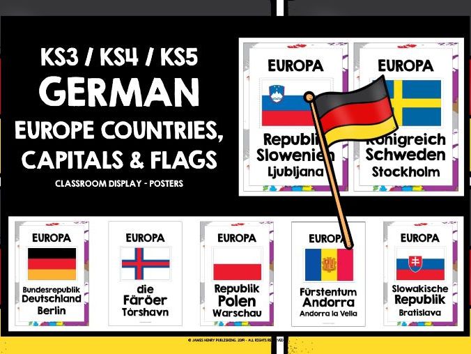
GERMAN EUROPE COUNTRIES, CAPITALS AND FLAGS POSTERS IN GERMAN GCSE GERMAN EUROPE POSTERS KS4 GERMAN EUROPE POSTERS KS3 GERMAN EUROPE POSTERS KS5 GERMAN EUROPEAN COUNTRIES, CAPITAL CITIES, FLAGS POSTERS
Files are non-editable in a zipped format. This product is copyright, all rights reserved. It is illegal to copy, rewrite, amend, share or distribute outside your own classroom in any way. The license for purchase is a single-user license only. School / departmental licenses are available. Please read the Terms of Use carefully.
Perfect for exploring Europe and ideal for cross-curricular learning, aligning German and geography.
Create an instant introduction to Europe and brighten up German class with this set of 72 posters featuring all European countries, capital cities and flags. The posters give the learning environment a real German ambiance, at the same time promoting German as a living language, featuring in the everyday life of the classroom. The posters are useful as bell ringers / speaking prompts: ask questions such as ***Was ist die Hauptstadt von… ?***, Richtig oder falsch? Stockholm ist die Hauptstadt von Grönland or In welchen europäischen Ländern ist Deutsch Amtssprache? to provide students with frequent opportunities to speak in German, which they often find challenging, particularly at the beginning of their German learning programme or after school holidays.
There may be a number of countries and capital cities that students do not know, or are not aware of, and the posters help them develop their general awareness, knowledge and understanding of Europe and its geography. The set features a range of islands, such as the Faroe Islands, as well as several countries, for example Armenia, that are often classed as belonging either to Europe or to Asia. Several countries, for example Germany, officially known as die Bundesrepublik Deutschland, feature two posters: choose either Deutschland or the official name to display.
Laminate if possible, as the posters will display really well, and remain in excellent condition for years. There are two backgrounds - either plain, to keep prep costs to a minimum, or the Europe map.
The LIvely Learning Classroom has a wide range of German resources, including special offer bundles and freebies.
VIELEN DANK UND SCHÖNE REISE NACH EUROPA!
EUROPE POSTERS IN GERMAN KS3 GERMAN KS4 GERMAN KS5 GERMAN EUROPE COUNTRIES & CAPITAL CITIES GERMAN CROSS-CURRICULAR LEARNING EUROPE TWO MULTIPLE-CHOICE QUIZZES AND A SET OF POSTERS SHOWING EUROPEAN COUNTRIES, CAPITAL CITIES & FLAGS
Files are non-editable in a zipped format. This product is copyright, all rights reserved. It is illegal to copy, rewrite, amend, share or distribute outside your own classroom in any way. The license for purchase is a single-user license only. School / departmental licenses are available. Please read the Terms of Use carefully.
German Europe 2 multiple-choice quizzes Ideal for cross-curricular learning in German class: students can develop their knowledge of the geography of Europe in a cooperative, communicative and interactive way, independently of the teacher. At the same time, students are developing their German language skills: speaking, listening and reading in particular, as well as broadening their German vocabulary. Play both as a whole-group team quiz, and in pairs or small groups on a regular basis - students are particularly keen to see if they can beat their own points record, and are really motivated by their developing knowledge.
The set contains all European countries and capital cities, including some island communities such as the Faroe Islands and Guernsey. Each question has 4 answers to choose from. The correct answer is given in capital letters. The quiz cards are numbered, but questions can be asked in random order too: simply place all the cards in a bowl, box or tin, and work your way through.
There are two quiz challenges:
= Challenge 1 gives the country as a prompt, with four possible capital cities to choose from.
= Challenge 2 gives the capital city as a prompt, with four possible countries to choose from. This challenge uses the definite article in the responses to help consolidate students’ knowledge of the gender of individual countries and the use of the dative following the preposition von.
German Europe Posters useful for creating and instant and comprehensive introduction to Europe in German. There are 144 portrait posters (A4, 8.5 x 11) in German showing European countries, capital cities and flags. There may be a number of countries and capital cities that students do not know, or are not aware of, so the posters can help students develop their general knowledge and understanding of European geography.
The Lively Learning Classroom has a wide range of German resources, including special offer bundles and freebies.
VIELEN DANK UND SCHÖNE REISE!
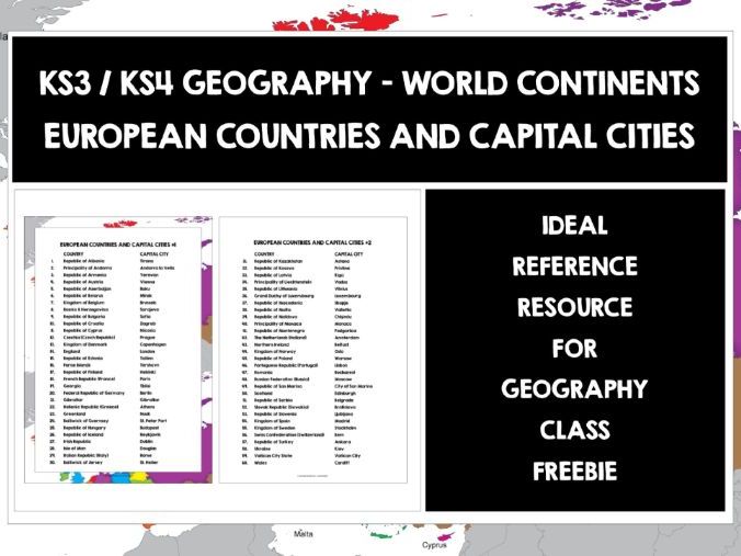
EUROPE COUNTRIES AND CAPITALS LIST KS3 GEOGRAPHY EUROPE COUNTRIES AND CAPITALS LIST KS4 GEOGRAPHY EUROPE EUROPEAN COUNTRIES AND CAPITAL CITIES LIST FREEBIE
Files are non-editable in a zipped format. This product is copyright, all rights reserved. It is illegal to copy, rewrite, amend, share or distribute outside your own classroom in any way. The license is a single-user license only. Please read the Terms of Use carefully. The product is free to download, but Terms of Use still apply.
Ideal reference resource for geography class, really useful for developing locational knowledge and awareness of world continents, and a great way to learn about Europe, its countries and capital cities. The list features 60 European countries, including several, for example Armenia, that are often classed as located in Asia, but also lie partly in Europe. The list also features island communities, such as the Faroe Islands and Guernsey.
There are two design formats to choose from - Europe map background, and plain without frame to keep prep costs to a minimum.
The Lively Learning Classroom has a wide range of geography resources, including special offer bundles and freebies.
THANKS AND ENJOY YOUR TRIP AROUND EUROPE!
EUROPEAN DAY OF LANGUAGES EUROPE COUNTRIES & CAPITAL CITIES LIST FREEBIE
Files are non-editable in a zipped format. This product is copyright, all rights reserved. It is illegal to copy, rewrite, amend, share or distribute outside your own classroom in any way. The license is a single-user license only. Please read the Terms of Use carefully. The product is free to download, but Terms of Use still apply.
Ideal reference resource, also useful for quizzes, guessing games and team competitions across the school year, but especially on the European Day of Languages - a great teacher time-saver too, if you’re preparing resources on Europe, its countries and capital cities, the list is the perfect short-cut.
The Lively Learning Classroom has a wide range of resources for the European Day of Languages, including special offer bundles and freebies.
THANKS AND ENJOY YOUR EUROPEAN DAY OF LANGUAGES!
SPANISH-SPEAKING COUNTRIES KS3 SPANISH KS4 SPANISH GCSE SPANISH KS5 SPANISH SPANISH-SPEAKING COUNTRIES SPANISH FOR CHILDREN BEGINNER SPANISH WORD SEARCH WITH ANSWER KEY FREEBIE
Files are non-editable in a zipped format. This product is copyright, all rights reserved. It is illegal to copy, rewrite, amend, share or distribute, in part or in whole, outside your own classroom in any way. The license is a single-user license only. Please read the Terms of Use carefully. This product is free to download, but Terms of Use still apply.
Sopas de letras are a fabulous way of encouraging students to engage with the written word in Spanish, refreshing and reinforcing language as they complete the search grid. This freebie focuses on a range of countries where Spanish is an official language, with a national flag prompt. Students have to recognize the flag in order to know which country to search for in the grid. The activity really does help students develop their knowledge and awareness of the Spanish-speaking world, and just how widely Spanish is spoken around the globe.
The Lively Learning Classroom has a wide range of Spanish resources, including special offer bundles and freebies.
¡MUCHAS GRACIAS Y BUEN VIAJE!