Full terminology
Starter: key term with word bank
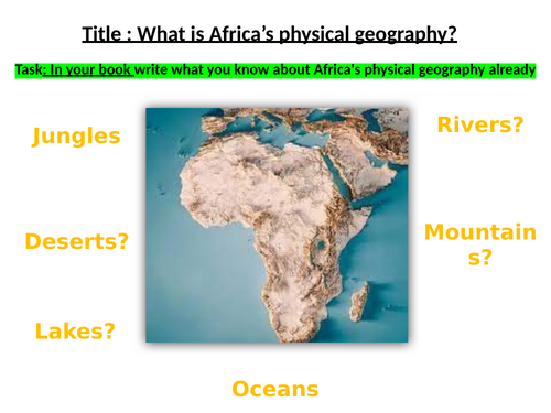
Map reading skills
Describe locations
Examples I do, we do, you do
Peer assessment
Hinge questions AFL
Biome information to read - optional methods/ tasks/ printouts if wanted
Map included for biome annotations
Journey through Russia Map (A, B, C, D)
Describe the biomes, what you see, etc throughout your journey
Success Criterion
Example (I do)
We do - together example
Answers for peer assessment
Plenary
Challenges included: these may be considered “hard” for KS3 but you can teach it or adapt them.
Engaged, fun task. You may need to finish earlier as students tend to not want to finish/ rush and continue/ willing to work into their breaks (but I don’t want them with me at break).
Rivers, Mountains, Deserts, Plains etc.
Prior knowledge check
Video - add to knowledge
Map creation - colour coded and Atlas use
2 versions - 1. blank (students had to really look and discover/ engage with the Atlas), they will ask for help or you can give prompts for harder ones. 2. Marked map (labelled)
Note: I only gave easier maps to students who go to special centres but my low ability and SEND students still did the blank map (they don’t complete it but they learn how to search and use the Atlas well). I did this because it is not in their assessment to know every part and map skills is more valuable for them.
Answers on board for marking
Reading information
Plenary
Extra version of map with key provided for lower ability/ SEND if you wish to use.
I included an example of a fieldwork booklet.
It is adaptable and sections can be removed depending on how much time you have.
This school was huge and they walked around separately as we had 4 buses of students.
Since we walked, I was the guide and mentioned all the prices etc.
The school is deprived so you need to address misconceptions during evaluation on whether it was successful or not as the students will think these big shops are amazing/ or unaware due to their hometown being small.
With a different school, we did the boat tour instead so they were able to easily take photos to annotate, write a lot and complete a full booklet (different to this booklet). In that booklet, the main difference was we added a map of the locations the boat goes and labelled it. Students made notes on each part. The boat tour guide may know some things, otherwise I (and you) know the information already to share. On the boat tour, you’ll see the giant boat that Bristol paid millions to move a few yards down for “regeneration” of the food shops nearby. When walking, we never saw it.
Bristol has a lot of history and original butts, cranes etc. in the area which people may not know. Things like vegetation drainage, use of brown field sites etc. I included some information for you in case you are unaware, and some articles.
With other schools, they decided to not visit Bristol.
Height on maps
Gapfill and word banks
Spot height
Layer colouring
Contour lines
Explanation through colour coding, animations and different perspectives
Example drawing
2 minute video summarising
Option to draw contour lines on landscapes
Short tasks
Worksheet applying map skills onto OS map
All answers pop up
Includes higher thinking skills for those who need challenges
Gapfill plenary
Helpsheet available for low ability
Photo senses starter
Key terms
Video
Story telling with tasks
Discussions, emotions, scenarios
Real story
Diary Example
Write your own diary
Diary helpsheet
Different emotions helpsheet (SEMH/ low ability)
Hard challenge included
This is for Year 12 mixed ability. I recommend printing the worksheets file as A3, and the rest can be as A4. It involves resources e.g. books, but also plenty of up-to-date/ live information which will need to be accessed with internet. E.g. computers, phones, or teacher can print them out from the website.
The exam board are aware of these A-level textbooks having older data, but students can infer information as years have gone by. Add information/ own knowledge, their knowledge when looking at boroughs and images. Bring the lesson alive. E.g. One student mentioned the Green Bridge that was unsuccessful, has a similar one built in Manchester instead.
Pages are included in the PPT.
The aim from the AQA spec: Case studies of two contrasting urban areas to illustrate and analyse key themes set out.
This includes:
patterns of economic and social well-being
the nature and impact of physical environmental conditions
with particular reference to the implications for environmental sustainability, the character of the study areas and the experience and attitudes of their populations.
Helpful materials:
Dictionary - expected key terminology for A level and above
white (fourth edition) Hodder A Level textbook - used in this lesson but I have attached a double sided page of information which can be used instead or in addition
cool geography
Update 2024: KS3, more creative, scaffolding, and materials added.
Lots of visuals
Poster task
Student examples included as ideas.
1hour lesson
Wheel of fortune sharing (built into PPT)
Lesson 7.1: Year 7, first class of climate change (causes)
Lesson plan (1 page bullet pointed each section)
Powerpoint (to follow with the powerpoint) - leaflet/ writing task
PPT has videos and built in timer to help you keep your time management.
Alter as needed.
An impact of climate change - focus on biodiversity
Starter - definition of words. challenge included
Green pen - add to answers
Point left/ right for correct answers (AFL)
Students read intentions
Students read the maps (write a sentence) - sentence starter on whiteboard
Students read endangered line (understading - why?)
Mind map reasons - do a few examples and add on board first
Green pen add 3 more ideas
Key term conservation
Break down the word - bio / diversity = diverse stem (on white board)
Breakdown sustainable
Students to write down if they don’t know the words
Differentiated reading (3 versions to make it easier for teacher to split them)
Highlighting, writing ideas, challenges
Create a poster or fact file (depending on time)
success criterion - emphasise there is no marks for pretty work - to do it after the writing
challenge
e.g. my year 8s wrote half a page of information (mixed ability) for fact files
e.g. my year 9s wanted to do more drawings (mixed ability) so their work varied but they were really into it and would need more time.
Feedback to class (table or notes - they were much faster with just making notes) - chose 1 per animal - visualiser for recognition and rewards
Plenary - which one to save? Hands up voting.
Learning outcomes:
Define the term NEE and give examples.
Rank and justify the improvements you would make to an LIC.
Investigate an African NEE country.
Each time you do one, you refer back to it via AFL with students
Strong focus on command words as these will be in exam questions (for young or older students to be aware of the meaning of these)
Scenario based thinking on own.
Pair work on same scenario but having to agree on one decision together.
Feedback to class
Learning Social/ Economic/ Environmental/ Political. Questions/ prompts per section to help students answer or categorise properly. Do an example together. Model it (especially if they are younger or have needs, otherwise it is already displayed on board)
Students read information and put them into the correct categories (10 minutes). AFL and check whole room progress. I added additional 3 minutes with their goal to have one thing per box as 2-3 boxes were mainly done. Challenge included if needed.
Random sharing. Depending on your student you can allow them to share any box, or you choose a box (but lower ability/ SEND may not have the box you want).
Plenary for students to recheck the intentions and discuss if they met them. This shows their progress and understanding.
Handouts available. SEEP in colour or black and white. Information sheet in colour, and shared handouts to have them exposed to graphs, tables and maps, and to help their partner as the task may be difficult for some.
Assessment
Challenges included
Peer assessing
Show progress before and after.
4 marker question (to assist with end of unit assessment)
When finished, students to keep their books nice and presented etc.
Video
List 10 facts
Plenary discussion
Later:
Teacher mark and award marks, checks through books (every few weeks) - rewards for consistent effort, presentation etc, recognition of students within books, and in class next lesson.
e.g. postcards home for good work and special stamps, okay work stickers, improvements needed nothing (all is based on student’s progress on their ability)
Made 2023 - Xmas themed (adaptable theme by changing the image)
Geography quiz - location
What happened in 2023 (each month) quiz
True or False - geography
General knowledge quiz
Celebrity quiz
Music quiz
Sports quiz
Movie quiz
Dingbats (emojis) to guess Xmas songs
Higher or Lower quiz
Tie breaker question
All answers included
Different rounds
Lots of quizzes into one PPT - adaptable
Powerpoint for a 1hour lesson on waterfall formation. Adjustable depending on students’ ability and lesson time. Each level gets harder for them to remember.
Starter for students to think
Mind map alone/ do together
Label picture and explain/ students guess
Match key terms and definition
Video on formation
What happened in the video (with image): explanation by students
Storyboard explanation
Fill in the blanks(1)
Complete the order (2)
Team activity: spot the mistakes/ correct
Team activity: summarise formation/ feedback
Plenary: checking understanding of key terms by labelling the waterfall
Homework: learning the definitions for pop quiz (literacy skills)
Includes an optional worksheet as homework to reineforce formation
Climate graph recap
Map recap using TEA (gapfill, images and prompts)
Pairwork
Literacy task
Optional background information
Optional adjustable information for lower ability (information as hidden slides)
Silent work
Students teach each other
Comprehension
Well controlled activity
Support low ability (with more time/ prompts)
Gap fill
Worksheets
Challenge (can adapt to involve GCSE geography answers instead)
Fun and supportive class activity
Quick plenary to assess all
Pointless Gameshow starter!!! Fun.
Key terms
Use of key terms
Lots of AFL
Many images
Choropleth map
Atlas
Population
Challenges included
Example/ Model answer
Explain why the Sahara Desert is sparsely populated
Plenary
Engaging and exploring lesson through reading.
If you don’t have the book, you can print out the pages (included)
1.To describe why Africa is both cursed and blessed by geography.
2. To identify key challenges that Africa faces.
3. To develop a creative piece of work about Africa.
• Starter: 5 facts – 2 minutes
• Date and title
• Learning intentions
• Read the book 5 minutes and 2 min discussion task
• Comprehension questions (10minutes) – challenges included.
• Peer assessment
• Raise of hands to check their knowledge
• Design a poster
• Plenary: share your work
Support: Examples, Colour coded, Answers on board, Word bank, Images, Gapfill for lower ability/ SEND
Updated: Great lesson that I completed in several schools. It can fit in 1 hour, or easily be 2 hours.
Starter - differences in words
Differentiated reading variety: less options from easy to hard (polar bear has missing information for higher ability to think of answers). Full options provide a range of animals if you wanted to provide more variety, have a longer lesson etc.
Images and maps included
Endangered > Extinct line with examples included for understanding (helps lower ability a lot)
Mind map - with examples
Definitions included - break down of words (included in the lesson plan for how to do this)
Reading information - highlighting (make sure those with polar bears know they don’t have the 2nd highlighter which is prompted on PPT but depending on your students’ ability you may need to tell them). The original reading can be changed to beginning if the school runs reading session routines, this will make them more familiar with the text and ready for the task.
Create a fact file. Success Criterion included. Challenge included.
Fact file works better as students focus on writing (e.g. Yr 8s mixed ability did half a page in 5 minutes). I used this class in the best schools in Basingstoke. If you have more time, you may want to do a poster but ensure they do not spend ages designing, writing a title or drawing pictures as this shows no application of knowledge.
Students present their work. Depending on time and resources, you may want a table (removed from PPT) for them to complete as students present. Otherwise just some simple notes for extra information, but their in depth information will be displayed in their animal/ work.
Plenary. If time pair discussions, then class. In PPT, I’ve set as class vote due to time.
Reading materials include pictures, graphs, maps, statistics etc. so they have to think about the information.
Check students’ reading ages before you give them an animal.
Easiest is turtle, then Panda. Majority of students like Panda level.
Orangutan has the heavy text which should be given to those who enjoy reading and have a higher than average reading age.
E.g. grammar stream students were given polar bear, elephants, orangutans (but kept some pandas for any students who may happen to struggle on this topic).
1hr lesson
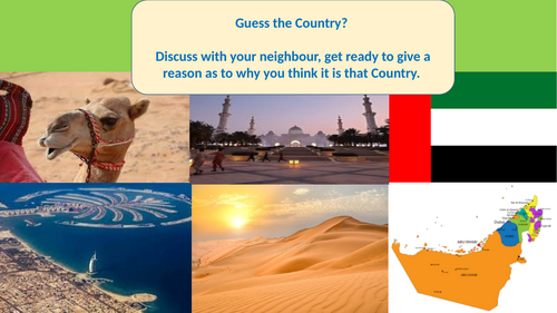
Guess the country images and flag
Describe the location - Atlas use and map
Video - fact information
A3 poster in pairs promoting tourism in airports
Success criteria included - slogans, pictures, facts
Images/ Montage of ideas
Peer assess (group swaps)
Plenary
Video
Information of key features
Colour code
Categorising between tourism/ ecotourism
Images and examples
Case study with worksheet and challenges
Design task with success criterion
Student example available