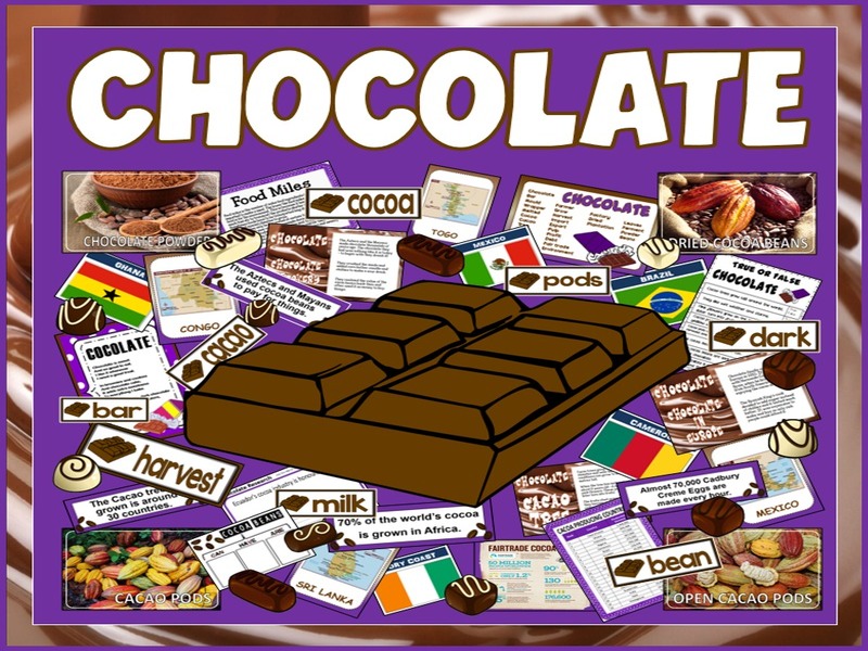
Resources included are as follows:
50 PDF OR PPT files for you to print.
Chocolate information pack – covering the history of chocolate, how it is grown, where it is grown etc
Photo pack of all stages of chocolate making, fact cards for reading or display, key word cards, chocolate bar wrapper photos, useful images for display, long banner, large lettering, backing paper for if needed, display borders, fair trade facts poster, fair trade logo, set of sequencing cards to put in order, folder cover, resources sack tag, poem poster, word mat, top 20 cacao producing countries table poster.
Continents maps for each continent where cacao is grown, outline maps of all continents, map flashcards of 30 countries that grow cacao, 30 flags from all countries.
Bingo game, 15 geography writing tasks for research all relating to the top 10 countries for chocolate production, make a presentation, all about chocolate booklet to complete, design a chocolate bar, draw a cacao tree, draw a box of chocolates, reward chart, mind map, noun and adjectives worksheet, colouring pages, ‘a day in the life’ writing task, acrostic poem to complete, can/have/are writing sheet, food miles research task and information, word search, writing border, writing booklet cover, sentence writing sheet for topic conclusion, story board template, door hanger to design, true or false quiz.
Included on the disc are the following resources:
1.Country information pack - covering all the key facts about the country – such as history, geography, language, landmarks, tourism etc.
2.A4 posters of photos of different things around the country – such as monuments, landmarks, mountains, scenery, homes, people etc
3.150 A5 flashcards of common things, such as household items etc
4.Airport departure board for display
5.Display lettering to make a departure board for different destinations
6.Writing borders to frame written work
7.Counting 5 minute lesson starters
8.47 European flags in A4 size
9.Acrostic poem task
10.Diary to complete – for activities, sight seeing, weather, food etc
11.Colouring pages of local foods, maps, activities, sites etc
12.Display flashcards with major topics relating to the country
13.Common phrases flashcards showing how to say different sentences in Polish
14.A4 letters to spell out country name
15.Long banner with country name on to head a display
16.Draw local lunchbox food task
17.Flashcards for days of the week in English and Polish
18.Extra large flag for display (Covering 3 x A4 pages)
19.Draw your favourite things from the country task
20.Flag colouring in pages
21.Flag matching tasks
22.Food flashcards
23.Country name garland for display
24.Writing booklet cover for pupils work
25.Holiday shop task – outdoor play activity
26.Holiday words treasure hunt and balancing activity
27.Map and city naming - cut and stick activity
28.Map of the world
29.Map of continent
30.Map of country
31.Map of languages spoken around Europe
32.Blank luggage tag for pupils to complete
33.Blank flight ticket, coach ticket and travel tickets for pupils to complete for holiday role play
34.Blank speech bubbles for pupils to fill in
35.Blank thought bubbles for pupils to complete
36.Folder, draw, resources box labels to keep all your resources together
37.Card matching game or traditional snap game
38.Country culture knowledge quiz
39.Flashcards of numbers 1-20 on flags
40.Open and closed signs to be used in role plays
41.Passport template for children to complete
42.Reaching and stretching activity for quiz answers
43.Tour guide badges for role plays
44.Reward chart templates for children to draw their favourite local pictures on
45.Matching cards game – can be used as a matching pairs or snap game
46.Display flashcards shows months of the year in English and Polish
47.Word search
48.Sentence writing activity
49.2 colourful borders to edge a display board
50.Photos of planes from different countries – great for role plays
51.Postcard template for pupils to complete
52.Story board template
Resources include:
Information
•Information packs for each country with an additional pack about Greenland.
Information packs include facts about the country, its location, geography, modern history, ancient history, climate, general information, famous people and inventions etc
Display
•Photo packs for each country
•Country names flashcards, key word flashcards, food flashcards, population statistics poster, A4 flags
Maps and Activities
•Maps of each country, Scandinavia, the Arctic circle, Europe, the world, continents, map jigsaw, maps to colour, matching cards, flag activities,
Language
(As Swedish is the most common language spoken across Scandinavia resources are included in this languages)
•Number flashcards from 1-20 in Swedish
•Days of the week in English and Swedish flashcards
•Months of the year flashcards in English and Swedish
•Common phrases cards – in English and Swedish
•Colour flashcards in Swedish
•A4 speech bubbles showing ‘hello’ in each Scandinavian language
Activities
•Themed writing paper with flags to frame pupils work
•Writing activities, drawing activities, make a presentation, research note pad, place mat, reward chart, word search, quiz, etc
Borders, Banners and Buntings
•Extra large lettering spelling ‘SCANDINAVIA’
•Long banners for each country name , buntings with names
•patterned and plain display borders and packing paper if needed
This is a great range of teaching resources, including everything you need to teach the topic of continents and oceans.
There are information packs about each of the continents, showing facts about the size, population, borders, culture, landmarks, sports etc.
Photo packs are included for each continent too, showing buildings, geographical feature, people, animals etc.
Other resources include maps of the world, maps of each continent, maps of each ocean, outline maps to colour and label. Many different mapping and compass activities,
100 A4 flags from around the world, flag activities, animal flashcard packs from each continent, key word cards, facts posters, fact booklets to complete, writing and drawing activities and display resources, such as lettering, banners, buntings, borders and backing paper.
Includes the following resources:
1.Interactive White Board Presentation – covering all the key facts about the country – such as history, geography, weather, landmarks, sports etc.
2.A4 posters of photos of different things around the country – such as monuments and landmarks.
3.Months of the year flashcards in English and Russian with pronunciation.
4.Common phrases flashcards – common phases in Russian with pronunciation aids
5.Russian alphabet A4 poster
6.Design your own Russian doll task
7.Russian food flashcards
8.Key word cards – large cards for display – words associated with Russia
9.Number flashcards 1-10 in English, Russian and with pronunciation
10.Airport departure board for display
11.Display lettering to make a departure board for different destinations
12.Writing borders to frame written work
13.Counting 5 minute lesson starters
14.Flags drawing, colouring and designing task
15.Bingo game
16.Word association activity
17.Animal flashcards of different animals specific to China
18.100 world flags in A4 size
19.Diary to complete – for activities, sight seeing, weather, food etc
20.Colouring pages of local foods, maps, activities, sites etc
21.A4 letters to spell out country name
22.Long banner with country name on to head a display
23.Draw local lunchbox food task
24.Blank luggage tag to complete
25.Blank speech and thought bubbles to complete in role plays
26.Flashcards for days of the week in English and Russian and pronunciation aids.
27.Extra large flag for display
28.Draw your favourite things from the country task
29.Flag colouring in pages
30.Country name garland for display
31.Writing booklet cover for pupils work
32.Holiday shop task – outdoor play activity
33.Holiday words treasure hunt and balancing activity
34.Map and city naming - cut and stick activity
35.Map of the world
36.Map of country
37.Country culture knowledge quiz
38.Flashcards of numbers 1-20 on flags
39.Open and closed signs to be used in role plays
40.Passport template for children to complete
41.Reaching and stretching activity for quiz answers
42.Tour guide badges for role plays
43.Reward chart templates for children to draw their favourite local pictures on
44.Matching cards game – can be used as a matching pairs or snap game
45.Display flashcards showing numbers 1-10 in English, Russian and pronunciation aids.
46.Word search
47.Sentence writing activity
48.Colourful borders to edge a display board
49.Photos of planes from different countries – great for role plays
50.Postcard template for pupils to complete
51.Story board template
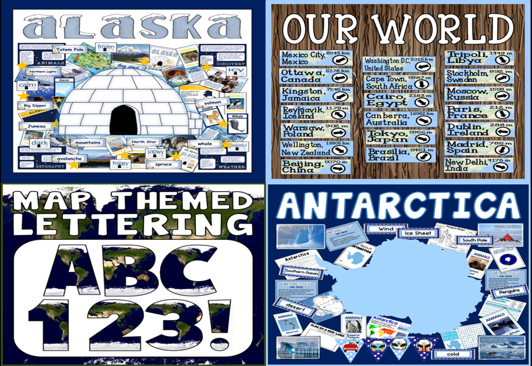
RESOURCES INCLUDED ARE AS FOLLOWS:
•Penguins facts cards, photo pack, species flashcards
•Antarctica information pack, maps, world maps, photo pack, writing task
•counting activities, sorting activities, book marks, addition games and subtraction game, acrostic poem, writing tasks, handwriting worksheets, counting cards, speaking and listening tasks, flag activities, craft activity, jumbled sentences, make a leaflet, door hanger, colouring pages, catching game, plus other activities
•Colour flashcards with penguin pictures, shapes posters, adjectives cards, alphabet flashcards, number flashcards, reward charts, HFW cards, drawer labels, odd and even number flashcards, phonics flashcards, writing posters, several penguin poems with matching resources, matching card game, word search, story board to write, writing booklet cover and borders,
Display materials; long banners, large lettering, penguin images, buntings, plain and patterned display borders
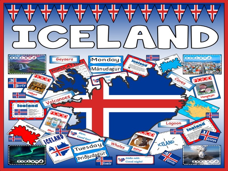
Resources included are as follows:
Iceland information pack, Photo pack, Food flashcards, Population poster
Maps of the world, continent and country, blank map to colour
Large letters for display title, long banner, flag, flag bunting, key word cards, plain and patterned display borders
Language resources: numbers flashcards, days flashcards, months flashcards, common phrases flashcards, colour flashcards
Acrostic poem to complete, All about Iceland booklet to complete, diary to write, favourite things to draw, flag drawing activities, making a list, draw food, make a presentation, mind map, newspaper template, postcard to send, research notes page, reward chart to draw, story board, true false signs for quizzes, sentence writing sheet, writing booklet cover and lined page for project work.
Resources included are as follows:
PDF file for you to print.
A range of 100 A4 flags from around the world.
A4 size but easy to print smaller by selecting ‘2 per page’ or ‘4 per page’ etc on your printer
200 colourful flashcards of geography words to print:
•Each flash card has a geography term on and a brief description.
•Words are suitable for key stage 2 to key stage 4.
•Size half A4 landscape per card.
•Colourful and bright cards sent to you on cd for you to print time and time again.
•These cards can be printed full size or smaller for each pupil, for revision and also make a great display around the classroom or halls.
•Adjust your printer settings to print smaller (select print 2 pages per page etc), or photocopy larger.
•Select just a few of these cards to highlight the key words for todays lesson or print them all to keep around for every day learning.
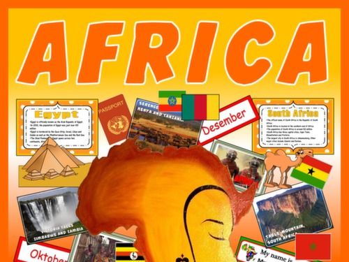
Information / Language / Maps
Information pack about Africa – including key facts about geography, history, science, culture etc
Information packs on each of the following countries:
Kenya, Egypt, Madagascar, Morocco, Nigeria, South Africa,
Information packs about the people of Africa, Luo tribe
Language resources in English and Afrikaans
A4 flags from all the African countries, map of languages and population, maps of Africa and the world, flag activities, map activity, etc
Activities
Africa bingo game, door hanger, animal activities and face masks, writing activities, drawing activities, craft activity, card matching game, colouring pages, weather activity, photo frames to add pictures, reward chart, reward chart, jobs flashcards to allocate pupils classroom jobs, president colouring pages, quiz, table name cards, fruit flashcards,
plus many others
Display
Poster pack of famous landmarks around Africa
Information pack about famous landmarks around Africa (Matches the photo pack)
Africa scene photo flashcards
Colour flashcards with cute camels and pyramid images
A5 animal flashcards, A4 animal posters, draw animals task, animal activities.
Drawer labels with monkey pictures
Key word flashcards – words such as poverty, population etc
Extra large letters to spell Africa – great for heading a wall display
Africa long banner, bunting, display borders, plus other display materials
Common sites around Africa posters – such as grain store, watering hole etc
Literacy and Numeracy
Many animal poems, writing activities, alphabet line, bookmarks,
Prefix explanation cards, suffix example and explanation cards
Adjectives and nouns matching cards
Synonyms cards, Antonym cards, pronoun cards and activity, short and long vowel spelling lists and word cards, sight word cards, discussion cards, reading posters, writing posters, shapes posters with an African theme, number bonds cards, number line, counting tasks, number flashcards, size ordering task
60 PDF or PPT files for you to print. Many can be used on whiteboard or computer screen too.
World cup information pack, logo, Qatar information pack, photo pack, groups table, large flags for all countries, picture of mascot, maps of the world/Asia/Middle East/Qatar, world cup dates poster, stadium posters to show areas of stadium for role play or school mini world cup, key word flashcards, country names flashcards,
certificates for sports, score board to make with letters and common words, 1 minute and 5 minutes timer, acrostic poem to complete, alphabetical order worksheet, clock to make for display, large letters to head wall display, long banner,
Qatar flag garland, A4 flag to photocopy larger, number bonds, drawing tasks, writing takes, design takes for football kit, soccer boots, trophy, logo mascot etc, word search, ordinal number flashcards, door hanger, newspaper report with template, coloured plain display border, ref badges for role play, quiz, number cards etc.
4 SPORTS RELATED PACKS
OUTDOOR ACTIVITIES IN ALL CURRICULUM AREAS
SPORTS RESOURCES AND DISPLAY
OLYMPICS RESOURCES
WORLD CUP RESOURCES WITH COLOURS RELATED TO THE UPCOMING 2018 EVENT
Resources included are as follows:
PDF files for you to print.
A great signpost to display around your classroom or school.
Includes 30 different worldwide destinations.
Each flashcard has the name of a capital city, the direction it is FROM LONDON and the distance.
Two sets of flashcards are included – one set in miles and the other set in kilometres.
Chose to display just a few signs or all of them. You could make one signpost or several depending on the display area.
Each sign is half an A4 in size landscape. You can print smaller by selecting options on the printer screen or photocopy them larger.
Also includes display lettering for title.
Resources included are as follows:
38 PDF files for you to print.
Information pack about Antarctica, photo pack, a range of posters and information sheets, key word flashcards, cut and stick activities for continents, label the continents, writing sheets, flag and activity, compass to use for display, acrostic poem to complete, animal flashcards, booklet to make, animal lists task, maps, collage to make, fact sheet to complete, presentation cue cards, mind map, sentence writing sheet, word search, large lettering patterned and plain, long banner to head display, buntings etc.
Resources included are as follows:
46 pdf or ppt files.
Information pack about Ireland, key word cards, photo pack of Ireland, maps of Ireland, Ireland outline map, UK / GB definitions, A4 Flag for display, flag colouring pages, flag tasks.
Large lettering, display borders, backing paper to print if needed, long banner for title, buntings., I love Ireland poster.
Face masks in colour and black and white, hand puppets in colour and black and white.
Drawing activities, design a rugby t-shirt, writing and drawing frames, reward chart, badges, word search, writing booklet cover, booklet to make, true or false quiz, sentences writing sheets, mind map, diary writing, presentation cue cards, alphabetical order worksheet, flight / coach / train tickets to complete, size order activity, passport to complete, postcard template, luggage tag to complete, Euro coin collage to make, resources sack tag and folder cover.
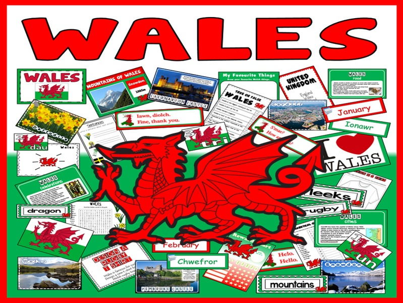
Resources included are as follows:
50 pdf files.
Information pack about Wales, key word cards, photo pack of Wales, maps of Wales, Wales outline map, UK / GB definitions, castle photo pack with facts, mountains posters with heights, A4 Flag for display, A4 flag to colour, number flashcards 1-20 in Welsh, common phrases flashcards in English and Welsh, days of the week and months of the year flashcards in English and Welsh
Large lettering, display borders, long banner for title, buntings, other large images to make a display board., I love Wales poster.
Face masks in colour and black and white, hand puppets in colour and black and white.
Drawing activities, design a rugby t-shirt, writing and drawing frames, reward chart, colouring pages, badges, word search, writing booklet cover, booklet to make draw daffodils task, true or false quiz, sentences writing sheets, mind map, diary writing, presentation cue cards, alphabetical order worksheet, coach and train tickets to complete, size order activity, resources sack tag and folder cover.
Resources included are as follows:
40 pdf files.
Information pack about St George’s day origins and traditions, key word cards, photo pack of England’s major cities, photo pack of English food, photo pack of English landmarks., maps of England, England maps and outline map, definition posters of UK/GB/BI
Large lettering, display borders, long banner for title, backing paper, buntings, happy st George’s Day poster, resources sack tag, binder cover.
Dragon face masks in colour and black and white, hand puppets in colour and black and white. drawing activities, writing and drawing frames, reward charts, badges, word search, writing booklet cover, booklet to make, St George’s flags in colour for display and to colour in, alphabetical order worksheet, diary writing sheet, mind map, sentence writing sheets, size order roses cards, true or false quiz.