Creative and innovative resources that meet the needs of every learner in every lesson.
Why create numerous resources when one can do it all.
Most resources are for geography lessons, but many are for whole-school too and cross over into numerous subjects.
Creative and innovative resources that meet the needs of every learner in every lesson.
Why create numerous resources when one can do it all.
Most resources are for geography lessons, but many are for whole-school too and cross over into numerous subjects.
A superb game that allows pupils to learn about the issues related to population in a fun, creative and engaging way.
This was used as part of our KS3 SOW.
Some coloured paperclips will be needed for the pupils to play this.
A 57 page revision guide designed for OCR A, paper 1. All with a UK focus.
Areas covered are:
Coasts
Population
Energy
Modifying the landscape for food & water
Rivers
Industry
Urban geography
Upland, lowland & glacial areas
Climate of the UK
It differs from a conventional guide because on each page it provides students with actual tasks to complete. E.g. sorting, linking, drawing, SPaG, spot the mistakes etc.
At the back there are dozens of questions that pupils can use the guide to help answer.
I printed lots off in colour and charged students £2 as well as providing them with a copy on disc. Some students just wanted a free disc copy & printed it at home.
Please see my other guides for paper2 & 3.
Although designed for OCR, much of the content is the same for other exam boards and it is very easily amended.
This took dozens of hours to create and will be an superb time save resource that will really support students of all ability.
4 revision guides designed for OCR A geography 1-9 GCSE course.
A unique guide has been created for each paper & one for more complex case study questions.
Many of the activities can actually be used as teaching resources/activities.
Areas covered are:
Grid References.
Scale.
Distance.
Height.
Fieldwork.
Statistics.
Q & A analysis.
Synoptic Q & A.
Coasts
Population
Energy
Modifying the landscape for food & water
Rivers
Industry
Urban geography
Upland, lowland & glacial areas
Climate of the UK
Development
Ecosystems
Extreme weather
Climate change
They differs from a conventional guide because on each page it provides students with actual tasks to complete. E.g. sorting, linking, drawing, SPaG, spot the mistakes etc.
At the back there are dozens of questions that pupils can use the guide to help answer.
The 2 statistic pages were printed on A3, laminated & provided to the pupils as last minute revision, whilst they were waiting to go into the exam hall.
I printed lots off in colour and charged students £2 as well as providing them with a copy on disc. Some students just wanted a free disc copy & printed it at home.
Although designed for OCR, most of the content is the same for other exam boards and it is very easily amended.
These took dozens of hours to create and will be an superb time saving resource that will really support students of all ability.
3 revision guides designed for OCR A geography 1-9 GCSE course.
A unique guide has been created for each paper.
Many of the activities can actually be used as teaching resources/activities.
Areas covered are:
Grid References.
Scale.
Distance.
Height.
Fieldwork.
Statistics.
Q & A analysis.
Synoptic Q & A.
Coasts
Population
Energy
Modifying the landscape for food & water
Rivers
Industry
Urban geography
Upland, lowland & glacial areas
Climate of the UK
Development
Ecosystems
Extreme weather
Climate change
They differs from a conventional guide because on each page it provides students with actual tasks to complete. E.g. sorting, linking, drawing, SPaG, spot the mistakes etc.
At the back there are dozens of questions that pupils can use the guide to help answer.
The 2 statistic pages were printed on A3, laminated & provided to the pupils as last minute revision, whilst they were waiting to go into the exam hall.
I printed lots off in colour and charged students £2 as well as providing them with a copy on disc. Some students just wanted a free disc copy & printed it at home.
Although designed for OCR, most of the content is the same for other exam boards and it is very easily amended.
These took dozens of hours to create and will be an superb time saving resource that will really support students of all ability.
A selection of geography skills activities. Choropleth mapping, Isoline mapping, proportional graphs & picture analysis. Covers all new 1-9 specifications. These are very structured and allow pupils to gain the basic detail of graphing requirements for all geography specifications.
An information sheet with all of the content needed for students to create a piece of work related to the causes, effects & how people have adaped to El Nino/drought. Students can create a poem, mindmap, article or any other independent task. Worksheet included to complete summary of key learning.
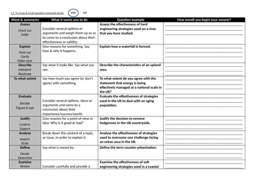
A work sheet (ideally printed in A3) that allows pupils to breakdown the correct way to answer specific command words in questions.
Designed for all levels and ages of pupils, but with a specific GCSE focus.
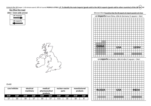
A full lesson on the major imports & exports to and from the UK.
Pupils create a flow line & proportional data presentation. They learn key content whilst putting it into a data/statistics content.
Includes marking statements that can be printed and stuck onto completed work.
Pupils loved this lesson.
Suitable for all 1-9 specifications. Just check the terminology is correct for the exam board that you are using.
This is a great task that asks students: What would we do if an asteroid was going to hit the earth?
It looks at the countries that would be effected, which involves some mapping & maths work.
It then goes on to looking at what the earths options would be. They choose what to do.
Finally pupils look at who they would choose to save.
A great SMSC or geography KS3 lesson.
A lesson that allows students to use a wide rage of skills in a really fun and engaging way.
Pupils design their character and vehicle and present there characteristics through detailed data presentation.
They then lead their troops to the alien base to defeat the enemy.
It’s probably the best lesson that I have created and my kids loved it.
Best used over 2 1hr lessons and with kids that have a basic grasp of maps and data, but it is not essential.
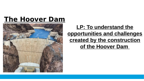
Resources for teaching about the Hoover Dam.
Students use the links in the powerpoint to make notes on the info sheet.
They then create a short presentation (extended writing).
It is very simple, but very effective.
A great lesson that enables students to create a tracing paper (GIS) overlay that identifies areas that are prone to flooding.
It works bes by photocopying onto tracing paper. This can easily be done by changing the settings on the photocopier.
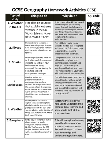
Homework ideas for the GCSE AQA geography specification.
They include QR codes that link to on-line resources.
These tasks require little to no marking, are fun and engaging and support the development of cultural capital in terms of creating great global citizens.
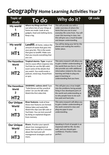
A wide range of home-learning activities that can be used across a range of year groups.
These asks are designed to be fun and engaging and require very little or no marking.
These activities include QR codes that link to video clips and are activities that will support the development of well-rounded global citizens.
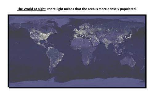
A fully resources lesson to provide students with and overview of the distribution of rainforests & deserts.
Students describe the distribution and then look at effective ways to describe graphs. This is an important geographical skill that supports pupils in picking up those easy marks in assessments.
The lesson has a focus upon the climate & location of deserts & tropical rainforests, but another layer for other ecosystems can easily be added.
I print the rainforest map onto tracing paper which the kids then put the base map in order to create a very simplified GIS map.
A lovely and simple lesson that allows pupils to understand what jobs may be available in the future.
It also enables pupils to practice and develop their note-taking skills. With particular reference to putting texts into their own words.
It was planned as an integral part of the KS3 Geography curriculum, but can also be used for PSHCE at a whole-school level.
A full lesson (powerpoint & resources) that enables pupils to develop a wide range of skills alongside learning about development indicators and how the world is so uneven.
Pupils analyse statistics and data.
Present the data in a number of ways using the scaffolded frameworks.
Look at analysis strategies.
Explain some of the data to explain why it varies.
This is best printed on A3.