
326Uploads
21k+Views
146Downloads
All resources

Country Study Memory Game Flashcards on Countries in Europe - Freebie
This Free product (Memory Game Cards) can be ideal for Geography and Social Studies Classes to learn about Countries in Europe. This Teaching Resource can be ideal for Middle Schoolers and High School Students as well.
In this Geography/Social Study Educational Resources (4 Printable PDF Worksheets) there are included:
48 European Countries (48 Memory Game Flashcards pairs; 96 cards)
1 card representing the country itself + its name in both English Language and local native language + its flag
1 card with the respective country’s capital city’s name
The European countries include in this Free Social Studies game are:
Albania (Tirana)
Andorra (Andorra la Vella)
Armenia (Yerevan)
Austria (Vienna)
Azerbaijan (Baku)
Belarus (Minsk)
Belgium (Brussels)
Bosnia and Herzegovina (Sarajevo)
Bulgaria (Sofia)
Croatia (Zagreb)
Cyprus (Nicosia)
Czechia (Prague)
Denmark (Copenhagen)
Estonia (Tallinn)
Finland (Helsinki)
France (Paris)
Georgia (Tbilisi)
Germany (Berlin)
Greece (Athens)
Hungary (Budapest)
Iceland (Reykjavík)
Ireland (Dublin)
Italy (Rome)
Kosovo (Pristina)
Latvia (Riga)
Lichtenstein (Vaduz)
Lithuania (Vilnius)
Luxembourg (Luxembourg)
Malta (La Valletta)
Moldova (Chisinau)
Montenegro (Podgorica)
Netherlands (Amsterdam)
Norway (Oslo)
Poland (Warsaw)
Portugal (Lisbon)
Romania (Bucharest)
Russia (Moscow)
San Marino (San Marino Città)
Serbia (Belgrade)
Slovakia (Bratislava)
Slovenia (Ljubljana)
Spain (Madrid)
Sweden (Stockholm)
Turkey (Ankara)
United Kingdom (London)
Ukraine (Kyiv)

Country Study Research Project - Kenya - Social Studies Report - East Africa
This Kenya Country Study Research Project is a perfect addition to your Geography and Social Studies curriculum, designed specifically for Middle School and High School students (Grades 7–12). Ideal for Country Study Activities, this printable, 2-page PDF teaching resource engages learners in exploring key aspects of Kenya (East Africa).
Use this Country Study Research Project on Kenya to guide students through the process of building a comprehensive Country Study Report, while enhancing their knowledge in areas such as geography, history, economy, language, and culture.
What’s Included in this Kenya Country Study Resource:
A QR code linking directly to Kenya’s location on Google Maps
Research-based geography questions about Kenya’s physical and political features
History-related questions to build context and understanding (East African History)
Language exploration questions (English + Swahili)
Economic overview questions on Kenya’s economy
A writing exercise to list major sights in Nairobi, the capital city
A task asking students to identify other key cities in Kenya
A final writing prompt encouraging students to describe elements of the Culture of Kenya

Country Study Research Project - Jordan - Social Studies Report - Middle East
This Jordan Country Study Research Project is a perfect addition to your Geography and Social Studies curriculum, designed specifically for Middle School and High School students (Grades 7–12). Ideal for Country Study Activities, this printable, 2-page PDF teaching resource engages learners in exploring key aspects of Jordan (West Asia - Middle East).
Use this Country Study Research Project on Jordan to guide students through the process of building a comprehensive Country Study Report, while enhancing their knowledge in areas such as geography, history, economy, language, and culture.
What’s Included in this Jordan Country Study Resource:
A QR code linking directly to Jordan’s location on Google Maps
Research-based geography questions about Jordan’s physical and political features
History-related questions to build context and understanding (West Asian History - Middle East)
Language exploration questions (Arabic)
Economic overview questions on Jordan’s economy
A writing exercise to list major sights in Amman, the capital city
A task asking students to identify other key cities in Jordan
A final writing prompt encouraging students to describe elements of the Culture of Jordan

Country Study Worksheets on Greenland - North America - Arctic
This Greenland Country Study Research Project is a perfect addition to your Geography and Social Studies curriculum, designed specifically for Middle School and High School students (Grades 7–12). Ideal for Country Study Activities, this printable, 2-page PDF teaching resource engages learners in exploring key aspects of Greenland (North America - Arctic).
Use this Country Study Research Project on Greenland to guide students through the process of building a comprehensive Country Study Report, while enhancing their knowledge in areas such as geography, history, economy, language, and culture.
What’s Included in this Greenland Country Study Resource:
A QR code linking directly to Greenland’s location on Google Maps
Research-based geography questions about Greenland’s physical and political features
History-related questions to build context and understanding (North American History - Arctic + Indigenous Peoples’ History)
Language exploration questions (Greenlandic + Danish)
Economic overview questions on Greenland’s economy
A writing exercise to list major sights in Nuuk, the capital city
A task asking students to identify other key cities in Greenland
A final writing prompt encouraging students to describe elements of the Culture of Greenland

US State Study Guide Worksheets on Wisconsin
Introducing the “US State Study Guide Worksheets: Wisconsin” – an engaging and educational printable PDF resource designed to enhance students’ understanding of the geography, history, and socio-economic fabric of Wisconsin. Perfect for middle and high school students (Grades 7–12), this set of two printable worksheets + teacher resource is ideal for Geography, US History, and Social Studies classrooms.
Whether you’re creating a comprehensive state-by-state unit or diving deep into Wisconsin specifically, this ready-to-use Wisconsin Study Guide offers a well-rounded approach to learning.
2 High-Quality Printable PDF Worksheets: These worksheets include multiple activities designed to stimulate critical thinking, promote research, and build foundational knowledge of Wisconsin. Each activity aligns with common curriculum standards and is ideal for in-class or homework use.
QR Code Linked to Wisconsin on Google Maps: Let students visualize Wisconsin’s exact geographical location with a scannable QR code that links directly to its position on Google Maps. This feature supports digital interactivity and geographic awareness.
In this “US State Study Guide Worksheets on Wisconsin” you can find:
• General Information Overview: Students answer key questions about Wisconsin’s population, area, state symbols, and other vital stats, building their knowledge through fact-finding.
• Etymology of the State Name: Explore the roots of the name Wisconsin, examining its origins and linguistic history. A great cross-disciplinary link to language and culture.
• Geography Challenge: Identify and label Wisconsin’s bordering states, analyze its physical terrain, and explore its climate zones. This reinforces regional geography and spatial awareness.
• Economy Exploration: Dive into the economic profile of the state.
• Historical Timeline: A blank timeline template is included for students to add major events from Wisconsin’s rich historical legacy.
• Capital City Spotlight: Investigate Wisconsin’s capital—its historical significance, cultural institutions, tourist sites, and more.
• Other Major Cities Activity: Students research and list 5 major cities in Wisconsin.

US State Study Guide Worksheets on Wyoming
Introducing the “US State Study Guide Worksheets: Wyoming” – an engaging and educational printable PDF resource designed to enhance students’ understanding of the geography, history, and socio-economic fabric of Wyoming. Perfect for middle and high school students (Grades 7–12), this set of two printable worksheets + teacher resource is ideal for Geography, US History, and Social Studies classrooms.
Whether you’re creating a comprehensive state-by-state unit or diving deep into Wyoming specifically, this ready-to-use Wyoming Study Guide offers a well-rounded approach to learning.
2 High-Quality Printable PDF Worksheets: These worksheets include multiple activities designed to stimulate critical thinking, promote research, and build foundational knowledge of Wyoming. Each activity aligns with common curriculum standards and is ideal for in-class or homework use.
QR Code Linked to Wyoming on Google Maps: Let students visualize Wyoming’s exact geographical location with a scannable QR code that links directly to its position on Google Maps. This feature supports digital interactivity and geographic awareness.
In this “US State Study Guide Worksheets on Wyoming” you can find:
General Information Overview: Students answer key questions about Wyoming’s population, area, state symbols, and other vital stats, building their knowledge through fact-finding.
Etymology of the State Name: Explore the roots of the name Wyoming, examining its origins and linguistic history. A great cross-disciplinary link to language and culture.
Geography Challenge: Identify and label Wyoming’s bordering states, analyze its physical terrain, and explore its climate zones. This reinforces regional geography and spatial awareness.
Economy Exploration: Dive into the economic profile of the state.
Historical Timeline: A blank timeline template is included for students to add major events from Wyoming’s rich historical legacy.
Capital City Spotlight: Investigate Wyoming’s capital—its historical significance, cultural institutions, tourist sites, and more.
Other Major Cities Activity: Students research and list 5 major cities in Wyoming.

US State Study Guide Worksheets on West Virginia
Introducing the “US State Study Guide Worksheets: West Virginia” – an engaging and educational printable PDF resource designed to enhance students’ understanding of the geography, history, and socio-economic fabric of West Virginia. Perfect for middle and high school students (Grades 7–12), this set of two printable worksheets + teacher resource is ideal for Geography, US History, and Social Studies classrooms.
Whether you’re creating a comprehensive state-by-state unit or diving deep intoWest Virginia specifically, this ready-to-use West Virginia Study Guide offers a well-rounded approach to learning.
2 High-Quality Printable PDF Worksheets
These worksheets include multiple activities designed to stimulate critical thinking, promote research, and build foundational knowledge of West Virginia. Each activity aligns with common curriculum standards and is ideal for in-class or homework use.
QR Code Linked to West Virginia on Google Maps
Let students visualize West Virginia’s exact geographical location with a scannable QR code that links directly to its position on Google Maps. This feature supports digital interactivity and geographic awareness.
In this “US State Study Guide Worksheets on West Virginia”, you can find:
General Information Overview: Students answer key questions about West Virginia’s population, area, state symbols, and other vital stats, building their knowledge through fact-finding.
Etymology of the State Name: Explore the roots of the name West Virginia, examining its origins and linguistic history. A great cross-disciplinary link to language and culture.
Geography Challenge: Identify and label West Virginia’s bordering states, analyze its physical terrain, and explore its climate zones. This reinforces regional geography and spatial awareness.
Economy Exploration: Dive into the economic profile of the state.
Historical Timeline: A blank timeline template is included for students to add major events from West Virginia’s rich historical legacy.
Capital City Spotlight: Investigate West Virginia’s capital—its historical significance, cultural institutions, tourist sites, and more.
Other Major Cities Activity: Students research and list 5 major cities in West Virginia.

US State Study Guide Worksheets on Washington
Introducing the “US State Study Guide Worksheets: Washington” – an engaging and educational printable PDF resource designed to enhance students’ understanding of the geography, history, and socio-economic fabric of Washington. Perfect for middle and high school students (Grades 7–12), this set of two printable worksheets + teacher resource is ideal for Geography, US History, and Social Studies classrooms.
Whether you’re creating a comprehensive state-by-state unit or diving deep into Washington specifically, this ready-to-use Washington Study Guide offers a well-rounded approach to learning.
2 High-Quality Printable PDF Worksheets: These worksheets include multiple activities designed to stimulate critical thinking, promote research, and build foundational knowledge of Washington . Each activity aligns with common curriculum standards and is ideal for in-class or homework use.
QR Code Linked to Washington on Google Maps: Let students visualize Washington exact geographical location with a scannable QR code that links directly to its position on Google Maps. This feature supports digital interactivity and geographic awareness.
In this “US State Study Guide Worksheets on Washington” you can find:
• General Information Overview: Students answer key questions about Washington’s population, area, state symbols, and other vital stats, building their knowledge through fact-finding.
•Etymology of the State Name: Explore the roots of the name Washington examining its origins and linguistic history. A great cross-disciplinary link to language and culture.
• Geography Challenge: Identify and label Washington bordering states, analyze its physical terrain, and explore its climate zones. This reinforces regional geography and spatial awareness.
• Economy Exploration: Dive into the economic profile of the state
•Historical Timeline: A blank timeline template is included for students to add major events from Washington rich historical legacy
•Capital City Spotlight: Investigate Washington’s capital—its historical significance, cultural institutions, tourist sites, and more.
• Other Major Cities Activity: Students research and list 5 major cities in Washington

US State Study Guide Worksheets on Virginia
Introducing the “US State Study Guide Worksheets: Virginia” – an engaging and educational printable PDF resource designed to enhance students’ understanding of the geography, history, and socio-economic fabric of Virginia. Perfect for middle and high school students (Grades 7–12), this set of two printable worksheets + teacher resource is ideal for Geography, US History, and Social Studies classrooms.
Whether you’re creating a comprehensive state-by-state unit or diving deep into Virginia specifically, this ready-to-use Virginia Study Guide offers a well-rounded approach to learning.
2 High-Quality Printable PDF Worksheets: These worksheets include multiple activities designed to stimulate critical thinking, promote research, and build foundational knowledge of Virginia . Each activity aligns with common curriculum standards and is ideal for in-class or homework use.
QR Code Linked to Virginia on Google Maps: Let students visualize Virginia exact geographical location with a scannable QR code that links directly to its position on Google Maps. This feature supports digital interactivity and geographic awareness.
In this “US State Study Guide Worksheets on Virginia” you can find:
• General Information Overview: Students answer key questions about Virginia’s population, area, state symbols, and other vital stats, building their knowledge through fact-finding.
•Etymology of the State Name: Explore the roots of the name Virginia examining its origins and linguistic history. A great cross-disciplinary link to language and culture.
• Geography Challenge: Identify and label Virginia bordering states, analyze its physical terrain, and explore its climate zones. This reinforces regional geography and spatial awareness.
• Economy Exploration: Dive into the economic profile of the state
•Historical Timeline: A blank timeline template is included for students to add major events from Virginia rich historical legacy
•Capital City Spotlight: Investigate Virginia’s capital—its historical significance, cultural institutions, tourist sites, and more.
• Other Major Cities Activity: Students research and list 5 major cities in Virginia

US State Study Guide Worksheets on "Vermont"
Introducing the “US State Study Guide Worksheets: Vermont” – an engaging and educational printable PDF resource designed to enhance students’ understanding of the geography, history, and socio-economic fabric of Vermont Perfect for middle and high school students (Grades 7–12), this set of two printable worksheets + teacher resource is ideal for Geography, US History, and Social Studies classrooms.
Whether you’re creating a comprehensive state-by-state unit or diving deep into Vermont specifically, this ready-to-use Vermont Study Guide offers a well-rounded approach to learning.
2 High-Quality Printable PDF Worksheets: These worksheets include multiple activities designed to stimulate critical thinking, promote research, and build foundational knowledge of Vermont . Each activity aligns with common curriculum standards and is ideal for in-class or homework use.
QR Code Linked to Vermont on Google Maps: Let students visualize Vermont exact geographical location with a scannable QR code that links directly to its position on Google Maps. This feature supports digital interactivity and geographic awareness.
In this “US State Study Guide Worksheets on Vermont” you can find:
• General Information Overview: Students answer key questions about Vermont ’s population, area, state symbols, and other vital stats, building their knowledge through fact-finding.
•Etymology of the State Name: Explore the roots of the name Vermont examining its origins and linguistic history. A great cross-disciplinary link to language and culture.
• Geography Challenge: Identify and label Vermont bordering states, analyze its physical terrain, and explore its climate zones. This reinforces regional geography and spatial awareness.
• Economy Exploration: Dive into the economic profile of the state
•Historical Timeline: A blank timeline template is included for students to add major events from Vermont rich historical legacy
•Capital City Spotlight: Investigate Vermont’s capital—its historical significance, cultural institutions, tourist sites, and more.
• Other Major Cities Activity: Students research and list 5 major cities in Vermont

US State Study Guide Worksheets on New Mexico
Introducing the “US State Study Guide Worksheets: New Mexico” – an engaging and educational printable PDF resource designed to enhance students’ understanding of the geography, history, and socio-economic fabric of New Mexico. Perfect for middle and high school students (Grades 7–12), this set of two printable worksheets + teacher resource is ideal for Geography, US History, and Social Studies classrooms.
Whether you’re creating a comprehensive state-by-state unit or diving deep into New Mexico specifically, this ready-to-use New Mexico Study Guide offers a well-rounded approach to learning.
2 High-Quality Printable PDF Worksheets: These worksheets include multiple activities designed to stimulate critical thinking, promote research, and build foundational knowledge of New Mexico. Each activity aligns with common curriculum standards and is ideal for in-class or homework use.
QR Code Linked to New Mexico on Google Maps: Let students visualize New Mexico exact geographical location with a scannable QR code that links directly to its position on Google Maps. This feature supports digital interactivity and geographic awareness.
In this “US State Study Guide Worksheets on New Mexico” you can find:
• General Information Overview: Students answer key questions about New Mexico’s population, area, state symbols, and other vital stats, building their knowledge through fact-finding.
• Etymology of the State Name: Explore the roots of the name New Mexico examining its origins and linguistic history. A great cross-disciplinary link to language and culture.
• Geography Challenge: Identify and label New Mexico bordering states, analyze its physical terrain, and explore its climate zones. This reinforces regional geography and spatial awareness.
• Economy Exploration: Dive into the economic profile of the state
•Historical Timeline: A blank timeline template is included for students to add major events from New Mexico rich historical legacy
• Capital City Spotlight: Investigate New Mexico’s capital—its historical significance, cultural institutions, tourist sites, and more.
• Other Major Cities Activity: Students research and list 5 major cities in New Mexico
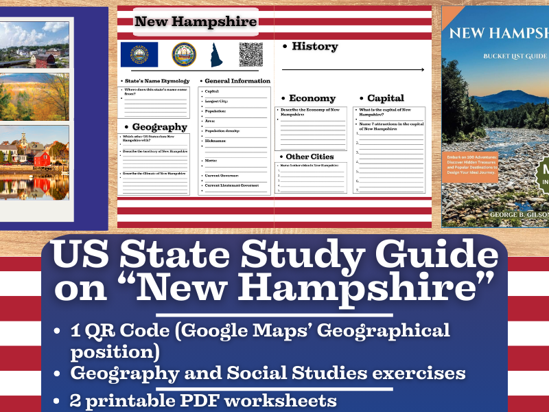
US State Study Guide Worksheets on New Hampshire
Introducing the “US State Study Guide Worksheets: New Hampshire” – an engaging and educational printable PDF resource designed to enhance students’ understanding of the geography, history, and socio-economic fabric of New Hampshire. Perfect for middle and high school students (Grades 7–12), this set of two printable worksheets + teacher resource is ideal for Geography, US History, and Social Studies classrooms.
Whether you’re creating a comprehensive state-by-state unit or diving deep into New Hampshire specifically, this ready-to-use New Hampshire Study Guide offers a well-rounded approach to learning.
2 High-Quality Printable PDF Worksheets: These worksheets include multiple activities designed to stimulate critical thinking, promote research, and build foundational knowledge of New Hampshire. Each activity aligns with common curriculum standards and is ideal for in-class or homework use.
QR Code Linked to New Hampshire on Google Maps: Let students visualize New Hampshire exact geographical location with a scannable QR code that links directly to its position on Google Maps. This feature supports digital interactivity and geographic awareness.
In this “US State Study Guide Worksheets on New Hampshire” you can find:
• General Information Overview: Students answer key questions about New Hampshire’s population, area, state symbols, and other vital stats, building their knowledge through fact-finding.
• Etymology of the State Name: Explore the roots of the name New Hampshire examining its origins and linguistic history. A great cross-disciplinary link to language and culture.
• Geography Challenge: Identify and label New Hampshire bordering states, analyze its physical terrain, and explore its climate zones. This reinforces regional geography and spatial awareness.
• Economy Exploration: Dive into the economic profile of the state
• Historical Timeline: A blank timeline template is included for students to add major events from New Hampshire rich historical legacy
• Capital City Spotlight: Investigate New Hampshire’s capital—its historical significance, cultural institutions, tourist sites, and more.
• Other Major Cities Activity: Students research and list 5 major cities in New Hampshire

US State Study Guide Worksheets on Utah
Introducing the “US State Study Guide Worksheets: Utah” – an engaging and educational printable PDF resource designed to enhance students’ understanding of the geography, history, and socio-economic fabric of Utah Perfect for middle and high school students (Grades 7–12), this set of two printable worksheets + teacher resource is ideal for Geography, US History, and Social Studies classrooms.
Whether you’re creating a comprehensive state-by-state unit or diving deep into Utah specifically, this ready-to-use Utah Study Guide offers a well-rounded approach to learning.
2 High-Quality Printable PDF Worksheets: These worksheets include multiple activities designed to stimulate critical thinking, promote research, and build foundational knowledge of Utah . Each activity aligns with common curriculum standards and is ideal for in-class or homework use.
QR Code Linked to Utah on Google Maps: Let students visualize Utah exact geographical location with a scannable QR code that links directly to its position on Google Maps. This feature supports digital interactivity and geographic awareness.
In this “US State Study Guide Worksheets on Utah” you can find:
• General Information Overview: Students answer key questions about Utah ’s population, area, state symbols, and other vital stats, building their knowledge through fact-finding.
•Etymology of the State Name: Explore the roots of the name Utah examining its origins and linguistic history. A great cross-disciplinary link to language and culture.
• Geography Challenge: Identify and label Utah bordering states, analyze its physical terrain, and explore its climate zones. This reinforces regional geography and spatial awareness.
• Economy Exploration: Dive into the economic profile of the state
•Historical Timeline: A blank timeline template is included for students to add major events from Utah rich historical legacy
•Capital City Spotlight: Investigate Utah ’ capital—its historical significance, cultural institutions, tourist sites, and more.
• Other Major Cities Activity: Students research and list 5 major cities in Utah

US State Study Guide Worksheets on Texas
Introducing the “US State Study Guide Worksheets: Texas” – an engaging and educational printable PDF resource designed to enhance students’ understanding of the geography, history, and socio-economic fabric of Texas Perfect for middle and high school students (Grades 7–12), this set of two printable worksheets + teacher resource is ideal for Geography, US History, and Social Studies classrooms.
Whether you’re creating a comprehensive state-by-state unit or diving deep into Texas specifically, this ready-to-use Texas Study Guide offers a well-rounded approach to learning.
2 High-Quality Printable PDF Worksheets: These worksheets include multiple activities designed to stimulate critical thinking, promote research, and build foundational knowledge of Texas. Each activity aligns with common curriculum standards and is ideal for in-class or homework use.
QR Code Linked to Texas on Google Maps: Let students visualize Texas exact geographical location with a scannable QR code that links directly to its position on Google Maps. This feature supports digital interactivity and geographic awareness.
In this “US State Study Guide Worksheets on Texas” you can find:
• General Information Overview: Students answer key questions about Texas’ population, area, state symbols, and other vital stats, building their knowledge through fact-finding.
•Etymology of the State Name: Explore the roots of the name Texas examining its origins and linguistic history. A great cross-disciplinary link to language and culture.
• Geography Challenge: Identify and label Texas bordering states, analyze its physical terrain, and explore its climate zones. This reinforces regional geography and spatial awareness.
• Economy Exploration: Dive into the economic profile of the state
•Historical Timeline: A blank timeline template is included for students to add major events from Texas rich historical legacy
•Capital City Spotlight: Investigate Texas’ capital—its historical significance, cultural institutions, tourist sites, and more.
• Other Major Cities Activity: Students research and list 5 major cities in Texas

US State Study Guide Worksheets on South Dakota
Introducing the “US State Study Guide Worksheets: South Dakota” – an engaging and educational printable PDF resource designed to enhance students’ understanding of the geography, history, and socio-economic fabric of South Dakota Perfect for middle and high school students (Grades 7–12), this set of two printable worksheets + teacher resource is ideal for Geography, US History, and Social Studies classrooms.
Whether you’re creating a comprehensive state-by-state unit or diving deep into South Dakota specifically, this ready-to-use South Dakota Study Guide offers a well-rounded approach to learning.
2 High-Quality Printable PDF Worksheets: These worksheets include multiple activities designed to stimulate critical thinking, promote research, and build foundational knowledge of South Dakota. Each activity aligns with common curriculum standards and is ideal for in-class or homework use.
QR Code Linked to South Dakota on Google Maps: Let students visualize South Dakota exact geographical location with a scannable QR code that links directly to its position on Google Maps. This feature supports digital interactivity and geographic awareness.
In this “US State Study Guide Worksheets on South Dakota” you can find:
• General Information Overview: Students answer key questions about South Dakota’s population, area, state symbols, and other vital stats, building their knowledge through fact-finding.
•Etymology of the State Name: Explore the roots of the name South Dakota examining its origins and linguistic history. A great cross-disciplinary link to language and culture.
• Geography Challenge: Identify and label South Dakota bordering states, analyze its physical terrain, and explore its climate zones. This reinforces regional geography and spatial awareness.
• Economy Exploration: Dive into the economic profile of the state
•Historical Timeline: A blank timeline template is included for students to add major events from South Dakota rich historical legacy
• Capital City Spotlight: Investigate South Dakota’s capital—its historical significance, cultural institutions, tourist sites, and more.
• Other Major Cities Activity: Students research and list 5 major cities in South Dakota

US State Study Guide Worksheets on Oregon
Introducing the “US State Study Guide Worksheets: Oregon” – an engaging and educational printable PDF resource designed to enhance students’ understanding of the geography, history, and socio-economic fabric of Oregon. Perfect for middle and high school students (Grades 7–12), this set of two printable worksheets + teacher resource is ideal for Geography, US History, and Social Studies classrooms.
Whether you’re creating a comprehensive state-by-state unit or diving deep into Oregon specifically, this ready-to-use Oregon Study Guide offers a well-rounded approach to learning.
2 High-Quality Printable PDF Worksheets: These worksheets include multiple activities designed to stimulate critical thinking, promote research, and build foundational knowledge of Oregon. Each activity aligns with common curriculum standards and is ideal for in-class or homework use.
QR Code Linked to Oregon on Google Maps: Let students visualize Oregon exact geographical location with a scannable QR code that links directly to its position on Google Maps. This feature supports digital interactivity and geographic awareness.
In this “US State Study Guide Worksheets on Oregon” you can find:
• General Information Overview: Students answer key questions about Oregon’s population, area, state symbols, and other vital stats, building their knowledge through fact-finding.
• Etymology of the State Name: Explore the roots of the name Oregon examining its origins and linguistic history. A great cross-disciplinary link to language and culture.
• Geography Challenge: Identify and label Oregon bordering states, analyze its physical terrain, and explore its climate zones. This reinforces regional geography and spatial awareness.
• Economy Exploration: Dive into the economic profile of the state
•Historical Timeline: A blank timeline template is included for students to add major events from Oregon rich historical legacy
• Capital City Spotlight: Investigate Oregon’s capital—its historical significance, cultural institutions, tourist sites, and more.
• Other Major Cities Activity: Students research and list 5 major cities in Oregon

US State Study Guide Worksheets on Oklahoma
Introducing the “US State Study Guide Worksheets: Oklahoma” – an engaging and educational printable PDF resource designed to enhance students’ understanding of the geography, history, and socio-economic fabric of Oklahoma. Perfect for middle and high school students (Grades 7–12), this set of two printable worksheets + teacher resource is ideal for Geography, US History, and Social Studies classrooms.
Whether you’re creating a comprehensive state-by-state unit or diving deep into Oklahoma specifically, this ready-to-use Oklahoma Study Guide offers a well-rounded approach to learning.
2 High-Quality Printable PDF Worksheets: These worksheets include multiple activities designed to stimulate critical thinking, promote research, and build foundational knowledge of Oklahoma. Each activity aligns with common curriculum standards and is ideal for in-class or homework use.
QR Code Linked to Oklahoma on Google Maps: Let students visualize Oklahoma exact geographical location with a scannable QR code that links directly to its position on Google Maps. This feature supports digital interactivity and geographic awareness.
In this “US State Study Guide Worksheets on Oklahoma” you can find:
• General Information Overview: Students answer key questions about Oklahoma’s population, area, state symbols, and other vital stats, building their knowledge through fact-finding.
• Etymology of the State Name: Explore the roots of the name Oklahoma examining its origins and linguistic history. A great cross-disciplinary link to language and culture.
• Geography Challenge: Identify and label Oklahoma bordering states, analyze its physical terrain, and explore its climate zones. This reinforces regional geography and spatial awareness.
• Economy Exploration: Dive into the economic profile of the state
•Historical Timeline: A blank timeline template is included for students to add major events from Oklahoma rich historical legacy
• Capital City Spotlight: Investigate Oklahoma’s capital—its historical significance, cultural institutions, tourist sites, and more.
• Other Major Cities Activity: Students research and list 5 major cities in Oklahoma

US State Study Guide Worksheets on Pennsylvania
Introducing the “US State Study Guide Worksheets: Pennsylvania” – an engaging and educational printable PDF resource designed to enhance students’ understanding of the geography, history, and socio-economic fabric of Pennsylvania. Perfect for middle and high school students (Grades 7–12), this set of two printable worksheets + teacher resource is ideal for Geography, US History, and Social Studies classrooms.
Whether you’re creating a comprehensive state-by-state unit or diving deep into Pennsylvania specifically, this ready-to-use Pennsylvania Study Guide offers a well-rounded approach to learning.
2 High-Quality Printable PDF Worksheets: These worksheets include multiple activities designed to stimulate critical thinking, promote research, and build foundational knowledge of Pennsylvania. Each activity aligns with common curriculum standards and is ideal for in-class or homework use.
QR Code Linked to Pennsylvania on Google Maps: Let students visualize Pennsylvania exact geographical location with a scannable QR code that links directly to its position on Google Maps. This feature supports digital interactivity and geographic awareness.
In this “US State Study Guide Worksheets on Pennsylvania” you can find:
• General Information Overview: Students answer key questions about Pennsylvania’s population, area, state symbols, and other vital stats, building their knowledge through fact-finding.
• Etymology of the State Name: Explore the roots of the name Pennsylvania examining its origins and linguistic history. A great cross-disciplinary link to language and culture.
• Geography Challenge: Identify and label Pennsylvania bordering states, analyze its physical terrain, and explore its climate zones. This reinforces regional geography and spatial awareness.
• Economy Exploration: Dive into the economic profile of the state
•Historical Timeline: A blank timeline template is included for students to add major events from Pennsylvania rich historical legacy
• Capital City Spotlight: Investigate Pennsylvania’s capital—its historical significance, cultural institutions, tourist sites, and more.
• Other Major Cities Activity: Students research and list 5 major cities in Pennsylvania

US State Study Guide Worksheets on Rhode Island
Introducing the “US State Study Guide Worksheets: Rhode Island” – an engaging and educational printable PDF resource designed to enhance students’ understanding of the geography, history, and socio-economic fabric of Rhode Island. Perfect for middle and high school students (Grades 7–12), this set of two printable worksheets + teacher resource is ideal for Geography, US History, and Social Studies classrooms.
Whether you’re creating a comprehensive state-by-state unit or diving deep into Rhode Island specifically, this ready-to-use Rhode Island Study Guide offers a well-rounded approach to learning.
2 High-Quality Printable PDF Worksheets: These worksheets include multiple activities designed to stimulate critical thinking, promote research, and build foundational knowledge of Rhode Island. Each activity aligns with common curriculum standards and is ideal for in-class or homework use.
QR Code Linked to Rhode Island on Google Maps: Let students visualize Rhode Island exact geographical location with a scannable QR code that links directly to its position on Google Maps. This feature supports digital interactivity and geographic awareness.
In this “US State Study Guide Worksheets on Rhode Island” you can find:
• General Information Overview: Students answer key questions about Rhode Island’s population, area, state symbols, and other vital stats, building their knowledge through fact-finding.
•Etymology of the State Name: Explore the roots of the name Rhode Island examining its origins and linguistic history. A great cross-disciplinary link to language and culture.
• Geography Challenge: Identify and label Rhode Island bordering states, analyze its physical terrain, and explore its climate zones. This reinforces regional geography and spatial awareness.
• Economy Exploration: Dive into the economic profile of the state
•Historical Timeline: A blank timeline template is included for students to add major events from Rhode Island rich historical legacy
• Capital City Spotlight: Investigate Rhode Island’s capital—its historical significance, cultural institutions, tourist sites, and more.
• Other Major Cities Activity: Students research and list 5 major cities in Rhode Island

US State Study Guide Worksheets on South Carolina
Introducing the “US State Study Guide Worksheets: South Carolina” – an engaging and educational printable PDF resource designed to enhance students’ understanding of the geography, history, and socio-economic fabric of South Carolina Perfect for middle and high school students (Grades 7–12), this set of two printable worksheets + teacher resource is ideal for Geography, US History, and Social Studies classrooms.
Whether you’re creating a comprehensive state-by-state unit or diving deep into South Carolina specifically, this ready-to-use South Carolina Study Guide offers a well-rounded approach to learning.
2 High-Quality Printable PDF Worksheets: These worksheets include multiple activities designed to stimulate critical thinking, promote research, and build foundational knowledge of South Carolina. Each activity aligns with common curriculum standards and is ideal for in-class or homework use.
QR Code Linked to South Carolina on Google Maps: Let students visualize South Carolina exact geographical location with a scannable QR code that links directly to its position on Google Maps. This feature supports digital interactivity and geographic awareness.
In this “US State Study Guide Worksheets on South Carolina” you can find:
• General Information Overview: Students answer key questions about South Carolina’s population, area, state symbols, and other vital stats, building their knowledge through fact-finding.
•Etymology of the State Name: Explore the roots of the name South Carolina examining its origins and linguistic history. A great cross-disciplinary link to language and culture.
• Geography Challenge: Identify and label South Carolina bordering states, analyze its physical terrain, and explore its climate zones. This reinforces regional geography and spatial awareness.
• Economy Exploration: Dive into the economic profile of the state
•Historical Timeline: A blank timeline template is included for students to add major events from South Carolina rich historical legacy
• Capital City Spotlight: Investigate South Carolina’s capital—its historical significance, cultural institutions, tourist sites, and more.
• Other Major Cities Activity: Students research and list 5 major cities in South Carolina