I've worked in primary teaching for over 10 years and specialise in creating fun and engaging educational resources, particularly for Geography and History.
I've worked in primary teaching for over 10 years and specialise in creating fun and engaging educational resources, particularly for Geography and History.
This lesson is part of Exploring Spain, a Geography unit designed for upper KS2 students (Y4-6), but can also be taught as a stand alone lesson.
The presentation first recaps the climate zones of the world (i.e. tropical, temperate & polar zones) and locates Spain within these.
It then looks in more detail at Spain’s weather, climate zones and the climate of Madrid. Students are then encouraged to find clues about Madrid’s weather using a climate graph.
This lesson includes two activities:
Comprehension activity:
Students interpret climate graphs for Madrid and London and compare the climates of both cities.
ICT activity:
Students create their own climate graph for Madrid using Microsoft Excel.
If you like this resource, we would appreciate a review! We will happily send you a free resource in return for a review or useful suggestions/feedback. Contact us at ed@teachitforward.co.uk.
This lesson is part of a wider unit called Exploring St Lucia and is designed to teach KS2 students about a contrasting non-European country.
It first introduces students to the tropical climate zone and its associated weather (i.e. high temperatures, high rainfall, dry and wet seasons) and compares this with temperate climates such as that of the UK.
Students are then encouraged to interpret data from a climate graph for St Lucia. Finally, other aspects of a tropical climate are covered including tropical storms and hurricanes.
The accompanying true or false activity helps children to recap what they have learned about the climates of St Lucia and the UK. It is differentiated two ways:
Easier – Students have 6 true or false statements.
Harder – Students have 10 true or false statements.
Extension – Students complete a cloze procedure text about St Lucia’s weather and climate.
If you like this resource, we would appreciate a review! We will happily send you a free resource in return for a review or useful suggestions/feedback. Contact us at ed@teachitforward.co.uk.
This lesson is part of a wider cross-curricula unit called London Zoo which is designed for KS1 and lower KS2 students (Y2-4).
The engaging presentation takes students on a journey through the main events in the London Zoo’s history, from its founding by Sir Stamford Raffles to the arrival of Winnie the bear (the inspiration for Winnie the Pooh) and also more recent developments such as the opening of Tiger Territory.
The timeline activity reinforces this learning by encouraging students to place these events in chronological order. It is differentiated three ways:
Easier – Students place 8 events on the timeline (using stickers)
Medium – Students write 8 events on a timeline with dates
Harder – Students write 8 events on a timeline without dates
N.B. It is recommended that the activity sheets are photocopied to A3 size to fit the stickers and allow for children with larger handwriting.
If you like this resource, we would appreciate a review! We will happily send you a free resource in return for a review or useful suggestions/feedback. Contact us at ed@teachitforward.co.uk.
This lesson is part of a wider cross-curricula unit called London Zoo which is designed for KS1 and lower KS2 students (Y2-4).
The engaging presentation first introduces students to compass directions. It then challenges them to describe the location of animals at London Zoo using north, east, south and west.
In the activity, students describe the position of animals at London Zoo using compass directions. It is differentiated two ways:
Easier – Students have colour coded questions so they can locate animals quickly.
Harder – Students have to find the animals themselves.
Extension – Students are challenged to state the position of animals in relation to other animals (e.g. The owls are north of the gibbons).
If you like this resource, we would appreciate a review! We will happily send you a free resource in return for a review or useful suggestions/feedback. Contact us at ed@teachitforward.co.uk.
This lesson is part of a wider Geography unit called Great Missenden – A Village Settlement which is designed for students in upper KS2 (Y4-6).
First the presentation introduces students to satellite photos. It then challenges them to use their detective skills to identify various human and physical geographical features in and around Great Missenden.
In the writing activity, students try to identify features in satellite photos of Great Missenden, explaining the reasoning behind their ideas. It is differentiated three ways:
Easier – Student identify one feature in each satellite photo.
Medium – Student identify two features in each satellite photo.
Harder – Student identify three features in each satellite photo.
Extension - Students sort the features they have found in the satellite photos into human and physical geographical features.
If you like this resource, we would appreciate a review! We will happily send you a free resource in return for a review or useful suggestions/feedback. Contact us at ed@teachitforward.co.uk.
This lesson is part of a wider Geography unit called Great Missenden – A Village Settlement which is designed for students in upper KS2 (Y4-6).
In this lesson, students are introduced a high street survey, a great way of looking at land use in settlements. The presentation first outlines the RICEPOTS system for categorising land use and includes many photos of real world examples to aid understanding.
The activity challenges students to use Google Street View to work out the types of land use on Great Missenden High Street. It is differentiated three ways:
Easier – Students find the business name/land use of 10 places on Great Missenden High Street (with clues).
Medium – Students find the business name/land use of 14 places on Great Missenden High Street (with clues).
Harder – Students find the business name/land use of 14 places on Great Missenden High Street (no clues).
Extension – Students use Google Street View to survey a section of Great Missenden High Street by themselves.
If you like this resource, we would appreciate a review! We will happily send you a free resource in return for a review or useful suggestions/feedback. Contact us at ed@teachitforward.co.uk.
This resource is part of Tropical Rainforests, a Geography unit designed for students in KS2, but can also be taught as a stand alone lesson. All resources are compatible with both Microsoft Office and Google Workspace.
This comprehension activity is based on the BBC’s My World Amazon Special. It is a great way for students to learn more about the effect of deforestation on a native Amazon tribe, the Arara.
It also introduces students to other key groups with an interest in the Amazon including a ranching family, student protestors and a conservationist.
In the activity, students answer questions about the documentary:
Easier - Students answer comprehension questions with time hints to help them find answers in the video.
Harder - Students answer comprehension questions with no time hints.
A transcript of the documentary is also included in case computers are in short supply.
If you like this resource, we would appreciate a review! We will happily send you a free resource in return for a review or useful suggestions/feedback. Contact us at ed@teachitforward.co.uk.
This resource is part of Exploring Australia, a Geography unit designed for students in upper KS1 and lower KS2 (Y2-Y4). All resources are compatible with both Microsoft Office and Google Workspace.
First the presentation introduces satellite photos. Students initially examine satellite photos of famous world landmarks before moving on to investigate several Australian sites.
The activities challenge students to use their geographical detective skills to identify Australian landmarks from satellite photos:
Matching Activity:
Students match 10 Australian landmarks to their satellite photos.
Writing Activity:
Easier - Students investigate satellite photos of 8 Australian landmarks (using a writing frame).
Harder - Students investigate satellite photos of 10 Australian landmarks (writing in books).
Extension - Students choose an Australian landmark they would like to visit and explain why.
If you like this resource, we would appreciate a review! We will happily send you a free resource in return for a review or useful suggestions/feedback. Contact us at ed@teachitforward.co.uk.
This lesson is part of Exploring the United Kingdom, a Geography unit designed for KS1 and lower KS2 (Y2-4).
In the lesson, students learn about the four seasons and characteristics associated with each. First they have to guess each season using different clues. They then find out about the different types of weather associated with each season.
The colourful activity is differentiated three ways:
Easier – Students match 16 pictures (with labels) to the seasons.
Medium – Students match 20 pictures (with labels) to the seasons.
Harder – Students match 20 pictures to the seasons and label them.
If you like this resource, we would appreciate a review! We will happily send you a free resource in return for a review or useful suggestions/feedback. Contact us at ed@teachitforward.co.uk.
This lesson is part of Exploring Spain, a Geography unit designed for upper KS2 students (Y4-6), but can also be taught as a stand alone lesson.
First the presentation covers key vocabulary (e.g. population, currency). It then locates Spain within Europe, asks students what they know about Spain and challenges them to think of ways to find out more.
There are two activities:
Research Activity:
Students research Spain using information sources (e.g. information books or suggested websites).
Easier – Students research famous landmarks, people, wildlife and Spanish food.
Harder – Students choose their own topics to research.
Extension: – Students draw pictures for each topic or find appropriate images online.
Writing Activity:
Students write a fact file using the information they have found.
Easier – Students write about famous landmarks, people, wildlife and Spanish food.
Harder – Students write about their own topics.
Extension – Students draw pictures or stick photos into the boxes for each topic.
If you like this resource, we would appreciate a review! We will happily send you a free resource in return for a review or useful suggestions/feedback. Contact us at ed@teachitforward.co.uk.
This lesson is part of Understanding Trade, a Geography unit designed for students in upper KS2 (Y5-6).
The presentation introduces the concept of highest value exports. It then draws a link between a country’s highest value export and its human and physical resources (e.g. transport links, oil reserves). Four example countries and their highest value export are then looked at in more detail.
In the activity, students are challenged to identify the highest value exports and GDP/capita of countries around the world using Google Maps/atlases and an online map. The activity is differentiated three ways:
Easier – Students identify highest value exports of 25 countries
Medium – Students identify highest value exports and GDP/capita of 25 countries
Harder – Students identify highest value exports and GDP/capita of 30 countries
If you like this resource, we would appreciate a review! We will happily send you a free resource in return for a review or useful suggestions/feedback. Contact us at ed@teachitforward.co.uk.
This lesson is part of a wider unit called Exploring St Lucia and is designed to teach KS2 students about a contrasting non-European country.
The presentation explores the main geographical features of St Lucia and asks students to categorise these into human and physical.
The activity then challenges students to identify these features on a map of St Lucia. It is differentiated three ways:
Easier – Students identify human & physical features of St Lucia (with clues)
Medium – Students identify human & physical features of St Lucia (no clues)
Harder – Students identify human & physical features of St Lucia (no clues and students also have to draw arrows)
If you like this resource, we would appreciate a review! We will happily send you a free resource in return for a review or useful suggestions/feedback. Contact us at ed@teachitforward.co.uk.
This simple set of activities is a great way for students to sharpen their map skills and learn the location of the states of the USA.
The worksheets can be used as an introduction to the geography of the US for younger students or to revise core geographical knowledge with older students. The states are even numbered in the order in which they joined the Union! There are three activities:
Activity 1:
Students write numbers on a map to identify each US state.
Activity 2:
Students use an atlas or map and write in the full name of each US state.
Activity 3:
Students use state abbreviations to write in the full name of each US state.
For more Geography and History resources, check out our TES shop.
If you like this resource, please review it. We will happily send you a free resource of your choice in return for a review or useful suggestions/feedback. Contact us at ed@teachitforward.co.uk
This is the free planning overview for Our World, a comprehensive introduction to the geography of Planet Earth. A vocabulary page and topic title page are also included.
This unit is designed for students in KS1 and lower KS2 (Y1-3) and includes a variety of engaging lessons, differentiated activities and worksheets.
All the resources described in the planning are available on TES, either individually or as a bundle. Lessons include:
L1 – Completing a world map jigsaw
L2 – Identifying the continents and oceans of the world (FREE)
L3 – Where do we live?
L4 – Identifying human and natural features of the world
L5 – Investigating satellite photos of famous world landmarks
L6 – Introduction to compass directions
L7 – Identifying world climate zones
L8 – Identifying the countries and capitals of the UK (FREE)
If you like this resource, we would appreciate a review! We will happily send you a free resource in return for a review or useful suggestions/feedback. Contact us at ed@teachitforward.co.uk.
This is a simple matching activity to help children recognise and identify the continents of the world. It is suitable for children in KS1 & KS2.
This resource works well with the World map jigsaw and Continents and oceans of the world.
It can also be used to play Pelmanism, a fun game which promotes concentration and memory skills.
If you like this resource, we would appreciate a review! We will happily send you a free resource in return for a review or useful suggestions/feedback. Contact us at ed@teachitforward.co.uk.
This free lesson is an ideal introduction to the geography of the British Isles for students in KS1 and KS2. It is also part of Exploring the United Kingdom, a Geography unit designed for KS1 and lower KS2 (Y2-4).
The colourful presentation teaches students the countries, capitals and seas of the United Kingdom and Ireland. The activity worksheets are differentiated four ways:
Easier – Students identify the countries & capitals of the UK and Ireland (with a map prompt).
Medium – Students identify the countries & capitals of the UK and Ireland (with vocab & map prompt).
Harder – Students identify the countries & capitals of the UK and Ireland (with vocab but no map prompt).
Hardest – Students identify the countries, capitals and seas of the UK and Ireland (no vocab or map prompt).
If you like this resource, we would appreciate a review! We will happily send you a free resource in return for a review or useful suggestions/feedback. Contact us at ed@teachitforward.co.uk.
This lesson is part of a wider cross-curricula unit called London Zoo which is designed for KS1 and lower KS2 students (Y2-4).
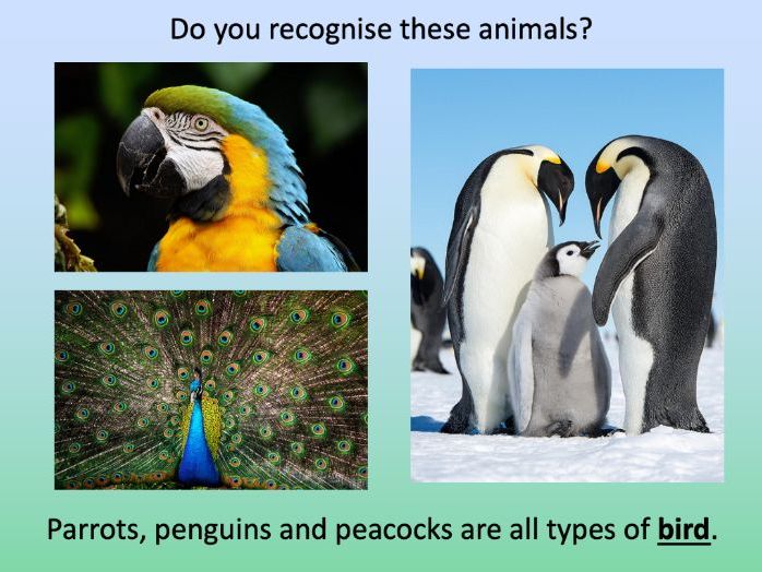
The colourful presentation introduces students to some of the animal groups children might see at London Zoo including mammals, fish, insects, birds, reptiles and amphibians.
The activity then takes students on a tour of the zoo and challenges them to record the animals they would see at different points in their journey. It is differentiated two ways:
Easier – Students identify 20 different animals (with first-letter clues).
Harder – Students identify 20 different animals (no clues).
N.B. The activity worksheet can be photocopied to A3 size to allow for children with larger handwriting.
If you like this resource, we would appreciate a review! We will happily send you a free resource in return for a review or useful suggestions/feedback. Contact us at ed@teachitforward.co.uk.
This lesson is part of Understanding Trade, a Geography unit designed for students in upper KS2 (Y5-6).
First the presentation introduces the banana trade and the concept of ‘supply chains’. Students are then challenged to sequence the banana supply chain in a group activity.
The Banana Split game, produced by Cafod, is then introduced. This is a great way to help children understand the uneven distribution of power and money in the supply chains of many of every day foods. There is also an activity sheet for students to complete as they progress through the game.
Finally the Fairtrade movement is introduced as a way for consumers to improve the conditions of workers in developing countries around the world. In the plenary, Fairtrade is also linked to the UN Convention on the Rights of the Child.
If you like this resource, we would appreciate a review! We will happily send you a free resource in return for a review or useful suggestions/feedback. Contact us at ed@teachitforward.co.uk.
This is the free planning overview for Investigating Rivers, a comprehensive Geography unit about rivers. A topic title page is also included.
This unit is designed for students in KS2 from Y4 to Y6 and includes a variety of engaging lessons, differentiated activities and worksheets.
All the resources described in this unit plan are available on TES either as individual lessons or as a bundle. Lessons include:
L1 - Understanding the water cycle
L2 - Identifying features of a river system
L3 - Identifying characteristics of the three stages of a river
L4 - Investigating features of the River Thames
L5 - Thinking about the different ways we use water
L6 - Understanding the impacts of floods and droughts
If you like this resource, we would appreciate a review! We will happily send you a free resource in return for a review or useful suggestions/feedback. Contact us at ed@teachitforward.co.uk.
This lesson is part of a wider Geography unit called Great Missenden – A Village Settlement which is designed for students in upper KS2 (Y4-6).
This lesson is the last in the unit and is ideally done after the fifth lesson – Surveying Great Missenden High Street using Google Street View.
The presentation briefly outlines the RICEPOTS system for categorising land use. It then introduces students to a survey map showing land use in Great Missenden High Street.
The activity challenges students to interpret information from the survey. In the extension activity students complete a bar chart showing land use on Great Missenden High Street.
If you like this resource, we would appreciate a review! We will happily send you a free resource in return for a review or useful suggestions/feedback. Contact us at ed@teachitforward.co.uk.