I've worked in primary teaching for over 10 years and specialise in creating fun and engaging educational resources, particularly for Geography and History.
I've worked in primary teaching for over 10 years and specialise in creating fun and engaging educational resources, particularly for Geography and History.
This fun jigsaw activity is a great geography resource for reinforcing children’s knowledge of the world.
It is also available as part of the Our World topic, an introduction to the geography of Planet Earth for KS1 and lower KS2
The presentation introduces students to a map of the world and highlights physical features including the continents, oceans, rivers and mountain ranges.
The jigsaw puzzle activity is differentiated six ways. The age brackets below are a rough guide:
6 pieces – EYFS
12 pieces – EYFS/Y1
24 pieces – Y1/2/3
36 pieces – Y2/3/4
48 pieces – Y3/4/5
60 pieces – Y4/5/6
A guide map is included for students in Early Years and KS1. Challenge more able KS2 students to complete the puzzle without the guide map.
If you like this resource, we would appreciate a review! We will happily send you a free resource in return for a review or useful suggestions/feedback. Contact us at ed@teachitforward.co.uk.
This lesson is part of Investigating Rivers, a unit designed for upper KS2 (Y4-6).
First the presentation looks at sources of water and highlights the importance of this critical resource. It then introduces the main processes of the water cycle including key concepts such as evaporation, condensation and precipitation.
The activity then challenges students to label a diagram of the water cycle. It is differentiated three ways:
Easier – Students have all the label clues.
Medium – Students have only four label clues.
Harder – Students have no label clues.
Extension – Students complete a cloze procedure paragraph about the water cycle.
If you like this resource, we would appreciate a review! We will happily send you a free resource in return for a review or useful suggestions/feedback. Contact us at ed@teachitforward.co.uk.
This lesson is part of Understanding Trade, a Geography unit designed for students in upper KS2 (Y5-6).
The presentation first asks students to think about how the products we buy arrive in the shops. It then introduces the concept of supply chains. To explain this concept, students look at the processes involved in the production of milk.
There are two activities:
Group Activity:
Students sort and sequence four mixed up supply chains including those of bananas, T-shirts, bookshelves and coffee.
Individual Activity:
Students sequence the supply chains of bananas, T-shirts, bookshelves and coffee.
Easier – Students sequence supply chains (first and last process given)
Harder – Students sequence supply chains (no clues)
If you like this resource, we would appreciate a review! We will happily send you a free resource in return for a review or useful suggestions/feedback. Contact us at ed@teachitforward.co.uk.
This lesson is part of Understanding Trade, a Geography unit designed for students in upper KS2 (Y5-6).
First the presentation asks students to consider how everyday products arrive in our supermarkets. It then introduces and explains the concept of supply chains, looking specifically at the chocolate supply chain. There are two activities:
Group Activity:
The group activity challenges students to order the chocolate supply chain.
Writing Activity:
An accompanying writing activity is based on ‘The Story of Our Chocolate Journey’ (available on YouTube). It challenges students to sequence and explain the processes involved in the chocolate supply chain. It is differentiated three ways:
Easier – Students use a writing frame.
Harder – Students write in an exercise book using a vocabulary prompt.
If you like this resource, we would appreciate a review! We will happily send you a free resource in return for a review or useful suggestions/feedback. Contact us at ed@teachitforward.co.uk.
This lesson is part of a wider Geography unit called Great Missenden – A Village Settlement which is designed for students in upper KS2 (Y4-6).
The presentation introduces students to the concept of settlements and asks them to categorise them by size (e.g. hamlet, village, town, city, conurbation). It then introduces them to a range of human geographical features found in settlements (e.g. post offices, sports stadiums).
In the activity students identify a variety of human geographical features found in settlements. It is differentiated two ways:
Easier – Students identify the features of settlements with normal clues.
Harder – Students identify the features of settlements with jumbled up clues.
Extension – Students identify which types of settlements these features are usually found in.
If you like this resource, we would appreciate a review! We will happily send you a free resource in return for a review or useful suggestions/feedback. Contact us at ed@teachitforward.co.uk.
This lesson is part of Tropical Rainforests, a Geography unit designed for students in KS2, but can also be taught as a stand alone lesson. All resources are compatible with both Microsoft Office and Google Workspace.
First, the presentation introduces students to some of the animals which live in tropical rainforests around the world. Many of these are endangered species so the concepts of extinction and conservation are also covered.
Group Activity:
The group activity then challenges students to match photos of rainforest animals to their names and fact files.
Finally, students learn about a conservation success story - the mountain gorillas of the Congo River Rainforest.
If you like this resource, we would appreciate a review! We will happily send you a free resource in return for a review or useful suggestions/feedback. Contact us at ed@teachitforward.co.uk.
This lesson is designed for KS2 children. It can be taught as a stand alone lesson but is also available as part of two wider units, both of which are available on TES:
-Earthquakes
-Volcanoes & Earthquakes
The presentation looks at three famous earthquakes from the previous decade including Haiti (2010), New Zealand (2011) and Japan (2011).
The activity then challenges students to research an earthquake online (e.g. Simple Wikipedia) and write a fact file about it. A completed fact file about the earthquake in Christchurch in 2011 is included as an example.
Easier – Students research and create a fact file about their chosen earthquake.
Harder – Students research and create a fact file about their chosen earthquake plus insert a map and add photo captions.
If you like this resource, we would appreciate a review! We will happily send you a free resource in return for a review or useful suggestions/feedback. Contact us at ed@teachitforward.co.uk.
This lesson is part of Investigating Rivers, a unit designed for upper KS2 (Y4-6).
Students are first introduced to the three stages of a river – the upper course, middle course and lower course – and some of the key features of each. The presentation then challenges students to think about the characteristics of rivers in these different stages (e.g. altitude, channel width, water speed).
In the activity, students match descriptions to each stage of a river. It is differentiated two ways:
Easier – Students match colour-coded descriptions to either the upper, middle or lower course of a river.
Harder – Students match descriptions to either the upper, middle or lower course of a river.
If you like this resource, we would appreciate a review! We will happily send you a free resource in return for a review or useful suggestions/feedback. Contact us at ed@teachitforward.co.uk.
This lesson is part of The Seaside, a Geography unit designed for students in KS1 and lower KS2, but can also be taught as a stand alone lesson.
The presentation takes students on a tour of the seaside town of Lyme Regis, home of the famous 19th century paleontologist, Mary Anning.
On the way, students find out about a variety of tourist attractions and other features including the harbour, the Marine Aquarium and the Lyme Regis Museum.
The activity then challenges students to use their map skills to locate these features on a map of the town.
Easier - Students identify each feature of Lyme Regis by writing a number.
Harder - Students identify each feature of Lyme Regis by writing a name.
Extension - Students locate and circle other features of Lyme Regis using the map key.
If you like this resource, we would appreciate a review! We will happily send you a free resource in return for a review or useful suggestions/feedback. Contact us at ed@teachitforward.co.uk.
This lesson is part of Exploring the United Kingdom, a Geography unit designed for KS1 and lower KS2 (Y2-4).
This lesson encourages students to identify geographical features found in the city/countryside and think about the similarities and differences between urban and rural areas in the UK.
First the presentation shows small segments of images from around the United Kingdom and challenges students to work out whether they are from the city or countryside.
Children then complete a Venn diagram-based activity which can be done in two ways:
Group activity:
In pairs or trios, children sort images of the city and countryside using a Venn diagram. This can also be done using two PE hoops and makes a nice classroom display.
Individual activity:
Students sort city and countryside vocabulary using a Venn diagram:
Easier – Students sort 12 city/countryside words
Harder – Students sort 18 city/countryside words
If you like this resource, we would appreciate a review! We will happily send you a free resource in return for a review or useful suggestions/feedback. Contact us at ed@teachitforward.co.uk.
This lesson is part of Exploring Spain, a Geography unit designed for upper KS2 students (Y4-6), but can also be taught as a stand alone lesson.
The presentation first shows students how to work out a 4-figure grid reference.
The activity then challenges students to describe the position of different cities in Spain using 4-figure grid references. It is differentiated two ways:
Easier – Students locate Spanish cities using 4-figure grid references (with clues).
Harder – Students locate Spanish cities using 4-figure grid references.
Extension – Students identify Spanish cities using compass direction and grid reference clues.
If you like this resource, we would appreciate a review! We will happily send you a free resource in return for a review or useful suggestions/feedback. Contact us at ed@teachitforward.co.uk.
This resource is part of Exploring Australia, a Geography unit designed for students in upper KS1 and lower KS2 (Y2-Y4). All resources are compatible with both Microsoft Office and Google Workspace.
First the presentation recaps Australia’s location in the world. It then introduces Australia’s eight main states/territories and their capital cities.
The activity then challenges students to locate and identify Australia’s states/territories and major cities.
Easier - Students identify 8 cities and states/territories (first letter clues).
Harder - Students identify 10 cities and states/territories (no clues).
Extension - Students identify more Australian cities on their map.
If you like this resource, we would appreciate a review! We will happily send you a free resource in return for a review or useful suggestions/feedback. Contact us at ed@teachitforward.co.uk.
This resource is part of Exploring Australia, a Geography unit designed for students in upper KS1 and lower KS2 (Y2-Y4). All resources are compatible with both Microsoft Office and Google Workspace.
This lesson is a great introduction to any Austalia topic. First the presentation looks at Australia’s location in the Southern Hemisphere before exploring the country’s vast size and the countries surrounding it.
In the activity, students are challenged to locate Australia on a world map and label other significant features:
Easier - Students label a world map (with hints).
Harder - Students label a world map (no hints)
Extension - Students use a map to identify countries surrounding Australia.
If you like this resource, we would appreciate a review! We will happily send you a free resource in return for a review or useful suggestions/feedback. Contact us at ed@teachitforward.co.uk.
This lesson is part of The Seaside, a Geography unit designed for students in KS1 and lower KS2, but can also be taught as a stand alone lesson.
The presentation introduces students to islands, including these basic points:
Islands can be found in rivers, lakes or seas/oceans.
Islands can be found in hot and cold parts of the world.
Islands can vary in size from very small to very large (e.g. the British Isles).
The activity then challenges students to use their map skills to locate islands of the United Kingdom. This can be done using an atlas or the prompt maps included.
Easier - Students use the map prompt to identify 12 islands of the UK (using labels).
Medium - Students use the map prompt to identify islands of the UK (writing in the names).
Harder - Students use an atlas to identify 12 islands of the UK (writing in the names).
Extension - Students complete a cloze-procedure paragraph about islands.
If you like this resource, we would appreciate a review! We will happily send you a free resource in return for a review or useful suggestions/feedback. Contact us at ed@teachitforward.co.uk.
This lesson is part of Our World, a Geography unit designed for students in KS1 and lower KS2 (Y1-3), but can also be taught as a stand alone lesson.
The presentation first helps students understand the concepts of ‘human’ and ‘natural’. It then takes them on a journey around the world and challenges them to identify human and natural features of our planet (e.g. mountains, airports).
There are two associated activities:
Group activity:
Students match pictures of features of the world to their names and sort them into human and natural categories.
Individual activity:
Children identify photos of features of the world.
Easier – Students identify features of the world (no writing).
Harder – Students identify features of the world (writing).
Extension – Students label each feature as human (H) or natural (N).
If you like this resource, we would appreciate a review! We will happily send you a free resource in return for a review or useful suggestions/feedback. Contact us at ed@teachitforward.co.uk.
This lesson is part of Understanding Latitude and Longitude, a unit designed for students in upper KS2 and KS3. It can also be taught as a stand-alone lesson.
This lesson is specifically devised to help students read latitude and longitude with greater accuracy. Initially it scaffolds the learning of this skill with the use of guidelines, then encourages students to have a go without any aids.
The activity is differentiated two ways and includes an extension:
Easier – Students find the latitude and longitude of 12 points on a world map with guidelines.
Harder – Students find the latitude and longitude of 18 points on a world map with guidelines.
Extension – Students have a go at finding the coordinates of 12 points without guidelines.
If you like this resource, we would appreciate a review! We will happily send you a free resource in return for a review or useful suggestions/feedback. Contact us at ed@teachitforward.co.uk.
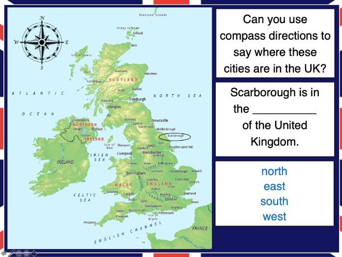
This lesson is part of Exploring the United Kingdom, a Geography unit designed for KS1 and lower KS2 (Y2-4).
N.B. If students are new to compass directions, use Introduction to compass directions to introduce the topic prior to this lesson.
First the presentation reminds students of the four cardinal compass directions. It then encourages them to use compass directions to describe the position of towns and cities around the UK.
In the activity, students have to find UK cities using compass clues. There are two differentiated activity worksheets:
Easier – Students locate cities using compass clues and starting letter clues.
Harder – Students locate cities using compass and harder starting letter clues.
Extension – Students complete cloze procedure sentence about the location of cities in the UK.
If you like this resource, we would appreciate a review! We will happily send you a free resource in return for a review or useful suggestions/feedback. Contact us at ed@teachitforward.co.uk.
This lesson is part of The Seaside, a Geography unit designed for students in KS1 and lower KS2, but can also be taught as a stand alone lesson.
The presentation introduces students to the seaside topic and then challenges them to identify features of the seaside (e.g. sandcastle, lifeguard) from partial picture clues.
In the activity, students identify and label seaside features:
Easier – Students label photos of seaside features (with initial letter clues).
Harder – Students label photos of seaside features (no clues)
Extension:
Easier – Students label seaside features in photos of Brighton Beach and a beach on the Isle of Harris.
Harder - Students write sentences about seaside features in photos of Brighton Beach and a beach on the Isle of Harris.
If you like this resource, we would appreciate a review! We will happily send you a free resource in return for a review or useful suggestions/feedback. Contact us at ed@teachitforward.co.uk.
This lesson is part of Our World, a Geography unit designed for students in KS1 and lower KS2 (Y1-3), but can also be taught as a stand alone lesson.
It aims to help younger students understand where they live. It looks at where Earth is in the solar system and then which continent, country and place they call home.
In the activity students write sentences about where they live. There are two differentiated worksheets:
Easier – Students fill in cloze procedure sentences to describe where they live.
Harder – Students write full sentences to describe where they live.
Extension – Students sort the names of countries, continents and planets into the correct categories.
If you like this resource, we would appreciate a review! We will happily send you a free resource in return for a review or useful suggestions/feedback. Contact us at ed@teachitforward.co.uk.
This lesson is part of Mountain Environments, a Geography unit designed for students in upper KS2 (Y4-6).
First the presentation recaps the structure of the Earth and how its crust is split into tectonic plates. It then investigates the different ways tectonic plates can move and how two tectonic plates colliding can form fold mountains (e.g. the Himalayas).
The differentiated activity challenges students to work out which tectonic plates formed different fold mountain ranges around the world.
Easier – Students have to find one tectonic plate.
Medium – Students have to find two tectonic plates.
Harder – Students find the name of each mountain range and two tectonic plates.
Extension – Students complete a cloze procedure paragraph about fold mountains.
If you like this resource, we would appreciate a review! We will happily send you a free resource in return for a review or useful suggestions/feedback. Contact us at ed@teachitforward.co.uk.