Head of Humanities with 10 years of experience teacher Geography + additional subjects in the UK and Internationally.
GCSE/IGCSE/MYP/IBPS
Additionallal subjest:
3 years Business Studies
3 years Computer Science
3 years Gobal Perspectives
Head of Humanities with 10 years of experience teacher Geography + additional subjects in the UK and Internationally.
GCSE/IGCSE/MYP/IBPS
Additionallal subjest:
3 years Business Studies
3 years Computer Science
3 years Gobal Perspectives
Complete, high quality lessons covering environmental systems and societies unit 8.3: solid domestic waster. Ready to pick up and teach, no extra planning needed and exam practice included.
Different types of solid domestic waste
The abundance and prevalence of non-biodegradable pollution
The linear vs circular economy
Waste disposal options include landfills, incineration, recycling
and composting.
What it says on the tin - a list of all the past 7 mark questions which have come up on cambridge GCSE Geography paper 1, organised by theme.
A great planning and revision resource.
Whole set of high quality lessons for Environmental systems and societies unit 1.4 Sustainability
Covers:
Sustainability
Ecological overshoot
Ecological foot print
Natural capital: goods and services
Environmental impact assessments
Carrying capacity is the maximum number of a species, or “load” that can be sustainably supported by a given area.
It is possible to estimate the carrying capacity of an environment for a given species; however, this is problematic in the case of human populations for a number of reasons.
An EF is the area of land and water required to support a defined human population at a given standard of living. The measure of an EF takes into account the area required to provide all the resources needed by the population, and the assimilation of all wastes.
EF is a model used to estimate the demands that human populations place on the environment.
EFs may vary significantly by country and by individual and include aspects such as lifestyle choices (EVS), productivity of food production systems, land use and industry. If the EF of a human population is greater than the land area available to it, this indicates that the population is unsustainable and exceeds the carrying capacity of that area.
Degradation of the environment, together with the consumption of finite resources, is expected to limit human population growth.
If human populations do not live sustainably, they will exceed carrying capacity and risk collapse.
A set of guided revision booklets, or a set of workbooks to use in class covering all of Environmental Systems and Societies Unit 2. 47 pages total.
Includes RAG grids, diagrams,key terms, questions and instructions on note taking.
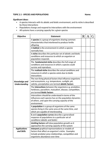
2.1: species and populations
2.2 Communities and ecosystems
2.3 Flows of energy and matter
2.4 Biomes, zonation succession
2.4 Investigating ecosystems
Complete set of resources for environmental systems and societies unit 2.1; power point and workbook.
Ready to pick up and teach no planning needed.
Includes: Ecosystem key terms
Population dynamics and limiting factors (J and S curves)
Interactions: Predation, herbivory, parasitism, mutualism, disease and competition
These resources cover the entire Cambridge IGCSE Geography course, paper 1, paper 2 and paper 4 (alternative to course work).
These high quality resources are successfully tried and tested in the classroom, with excellent results.
This includes everything you need to download and go…not extra planning. Powerpoints, worksheets, assessments and revision guides all included.
Full lessons for IB ESS topic 1: ready to pick up and teach - no extra planning needed.
Covers:
• Signifcant historical infuences on the development of the environmental
movement have come from literature, the media, major environmental
disasters, international agreements and technological developments.
• An EVS is a worldview or paradigm that shapes the way an individual, or
group of people, perceives and evaluates environmental issues, infuenced by
cultural, religious, economic and sociopolitical contexts.
• An EVS might be considered as a system in the sense that it may be
infuenced by education, experience, culture and media (inputs), and involves
a set of interrelated premises, values and arguments that can generate
consistent decisions and evaluations (outputs).
• There is a spectrum of EVSs, from ecocentric through anthropocentric to
technocentric value systems.
Full lessons for IB ESS topic 1: ready to pick up and teach - no extra planning needed.
Covers:
• A systems approach should be taken for all the topics covered in the
ESS course.
• These interactions produce the emergent properties of the system.
• The concept of a system can be applied at a range of scales.
• A system is comprised of storages and flows.
• The flows provide inputs and outputs of energy and matter.
• The flows are processes that may be either transfers (a change in location)
or transformations (a change in the chemical nature, a change in state or a
change in energy).
• In system diagrams, storages are usually represented as rectangular boxes
and flows as arrows, with the direction of each arrow indicating the direction
of each flow. The size of the boxes and the arrows may be representative of
the size/magnitude of the storage or flow.
• An open system exchanges both energy and matter across its boundary
while a closed system exchanges only energy across its boundary.
• An isolated system is a hypothetical concept in which neither energy nor
matter is exchanged across the boundary.
• Ecosystems are open systems; closed systems only exist experimentally,
although the global geochemical cycles approximate to closed systems.
An end of term Christmas/Geography quiz covering:
Christmas Geography
Events of 2023
Unusual Geography
World food
Cultural Geography
Currency
World landmarks
Artists and bands
Famous explorers
Ten questions for each round, followed by the answers
This is a complete set of resources to teach IB Diploma unit 1. It includes power points, case studies, group work and essay practice. It also includes exam style questions.
1.1 Environmental value systems
1.2 Systems and models
1.3 Energy and equillibria
1.4 Sustainability
1.5 Humans and pollution
All of the resources needed to teach Environmental Systems and Societies Unit 8: Human systems and resource use.
No planning needed - high quality resources
This IB MYP unit, titled “Think-Pair-Share: What Do We Already Know?” delves into understanding maps as vital tools that provide insights into time, place, and space, influenced by varying perspectives.
The resource is high quality, ready to teach, and requires no extra planning. It includes a complete unit of work featuring PowerPoints and worksheets, ensuring a comprehensive teaching experience.
Concepts
Global Concept: Time, space, and place
Related Concepts: Perspective, scale
Objectives
Find out about the different uses of maps and how they can be affected by a specific perspective.
Explore different examples of maps and how to use them.
Take action by considering ways that maps can communicate important information.
Assessment
Summative Assessment: Research, plan, and create a map of a fictional place.
Criterion B (iii, iv)
Criterion C (i, ii)
Criterion D (iii, iv)
Topics
What are maps?
Direction
Scale
Map ymbols
Grid Reference
Relief
Time, space, and place
The lessons include a mix of knowledge introduction, group work, pair work, research tasks, individual tasks, and assessment to enhance student understanding and engagement.
This I&S MYP unit on “Tectonic Hazards” explores the interactions of tectonic plates and the resulting phenomena such as earthquakes and volcanoes. The resource is high quality, ready to teach, and requires no extra planning. It includes a complete unit of work featuring PowerPoints and worksheets, ensuring a comprehensive teaching experience.
** Concepts**
Key Concept: Interactions
Global Context: Interactions
Inquiry Questions
Factual: How do tectonic plates move and interact with each other?
Conceptual: What are the underlying causes and mechanisms that lead to the formation of earthquakes and volcanic eruptions?
Debatable: To what extent can human activities contribute to the occurrence or intensity of tectonic events such as earthquakes or volcanic eruptions?
Assessment
Criterion A: Knowing and understanding
Criterion B: Investigating
Criterion C: Communicating
Criterion D: Thinking critically
Topics
Types of tectonic plate boundaries
Causes of earthquakes
Measuring and recording earthquakes
Types of volcanoes
Tsunamis
Case studies of major tectonic events and their consequences
Preparing and responding to hazards
The lessons include a mix of knowledge introduction, group work, pair work, research tasks, individual tasks, and assessment to enhance student understanding and engagement.
A complete 12 lesson scheme of work (plus assessment) fully resourced with power points and activities ready to go. Ready to pick up and teach.
Activities include (but not limited to)
card sorts
research
presentations
creative design
persuasive writing
Topics
introduction to the oceans
Ocean ecosystems
Coral bleaching
Ocean zones (plant and animal adaptations)
Oceans conservation and sustainability
Plastic and the oceans
Ocean exploration
Case study: the Maldives
Assessment
Some of these are double lessons, many have options to expand learning beyond.
All lessons and resources to teach Cambridge International GCSE Rivers. No extra planning needed.
Includes:
key terms
hydrological cycle
Erosion
Transportation
Deposition
Upper, middle and lower course landforms
Causes of flooding
Flood management
River case study - hazards, opportunities and management
A guided revision booklet covering Cambridge International GCSE Geography, Theme 2 The natural environment.
For each topic there are learning objectives, the ‘Bare Necessities’, key terms diagrams, and guided spaces to for students to complete.
This is a 51 page booklet covering:
Earthquake and volcanoes
Rivers
Coasts
Weather
Climate and vegetation
Plus a list of all of the recent 7 mark questions for Theme 1.
This unit covers everything the students need to know for Cambridge IGCSE paper 4 (alternative to course work). It includes teaching material plus loads of real exam practice questions (and mark schemes) for each question.
Topics covered:
Human
Hypothesis and aims
Describing relationships between variables
Primary vs secondary data examples
Surveys
Questionnaires
**Weather **
Instruments
Types of clouds
Measuring rain
Plotting data
Stevenson screens
Rivers
Velocity
Channel cross section
Equipment
Cross section
**Coasts **
Equipment
Longshore drift
Velocity/direction
Beach transects
A collection of all of the information students need to answer every 7 mark question on Cambridge IGCSE paper 1.
Includes:
Theme 1
A country which is over-populated.
A country which is under-populated
A country with a high rate of natural population growth.
A country with a low rate of population growth (or population decline)
An international migration.
A country with a high dependency ratio
A densely populated country or area (at any scale from local to regional).
A sparsely populated country or area (at any scale from local to regional).
Settlement and service provision in an area.
An urban area (including changing land use and urban sprawl).
A rapidly growing urban area in a developing country and migration to it.
Theme 2
An earthquake
A volcano
The opportunities presented by a river, the hazards associated with it and their management.
The opportunities presented by an area of coastline, the hazards associated with it and their management.
An area of tropical forest
Deforestation of a tropical rainforest
An area of dry desert
Theme 3
A farm or agricultural system
A country or region suffering from food shortages
An industrial zone or factory.
An area where tourism is important.
Energy supply in a country or area
Water supply in a country or area.
An area where economic development is taking place and causing the environment to be at risk.
Know a case study of a transnational corporation (TNC) and its global links.