Support your pupils’ learning and interest in European Geography with this 3-page colouring resource.
Including 45 European country flag templates, pupils will need to research the colours of each flag before colouring the individual flags in themselves.
This resource is ideal as an opening introduction to a Europe Scheme of Work, as a title page in exercise books or even as a display in the classroom.
Downloaded in PDF format.
This work booklet guides pupils through vital mapping skills by giving them a ‘how to guide’ as well as a chance to practise their new skills in a variety of questions and tasks. The booklet is aimed at children in upper KS2 and lower KS3 and can be easily adapted to suit. The booklet can be given at the end of a unit of work or spread out across several lessons.
The mapping skills included in this work booklet include:
4 Figure Grid References
6 Figure Grid References
Compass Directions
Contour Lines
Calculating Scale
Each topic above includes a one-page ‘how to guide’ and well as a corresponding 'activity sheet.'
Download is in pdf format.
Are you ready to turn this holiday season into a global adventure for your young explorers? Introducing our enchanting Christmas-themed geography map skills activity booklet, specially crafted for curious minds aged 10-14!
Festive Learning Fun: Transform geography lessons into a holiday celebration! Each activity is designed to weave Christmas magic into essential map skills, making learning both educational and joyous.
Engaging and Age-Appropriate: Tailored for 9-12 year olds, our activities strike the perfect balance between challenge and entertainment. Watch as your child hones their map-reading skills while embracing the holiday spirit.
Santa’s Global Adventure: Follow Santa’s journey around the world! From the North Pole to bustling cities and exotic landmarks, each activity unveils a new destination, fostering cultural awareness and geographical knowledge.
Map Skills Included:
Grid References
Scale & Distance
Compass Directions
Contour Lines
Time Zones
A total of 14 activity pages with answers included.
A high quality scheme of work, PowerPoints and worksheets focused on the Geography of Disease. This resource includes 6 lessons:
Epidemic vs. Pandemic
Disease Transmission
Mapping Diseases
The Role of Globalisation
Disease & Development
Preventing the Spread of Disease
Each of the six lessons come with a corresponding PowerPoint with a learning outcome and engaging activities included on the slides.
Essential geographical skills of mapping, handling and displaying data are embedded throughout the lessons.
This resource can be downloaded in PowerPoint format and pdf format and includes 6 PowerPoint presentations and 6 worksheets.
The perfect way to begin or end a unit of work around the world’s continents to consolidate keywords and global locations.
This resource is ideal for use with an atlas or digital device and includes clues as well as the keywords/answers at the top of each crossword.
There are seven individual crosswords included:
Global Location
Africa
Europe
Asia
North America
South America
Oceania
Each crossword comes with an answer sheet for use when marking or for pupil’s to self-mark.
Resource downloaded in pdf format.
Looking for a way to engage your pupils’ competitive spirit? The Big Geography Quiz is an ideal way to test geography knowledge of the wider world when completed in groups or as individuals.
There are 40 questions in total with four different rounds, each with 10 questions:
General World Knowledge
Picture Round
World Flags
Where Am I?
Downloaded in a pdf format.
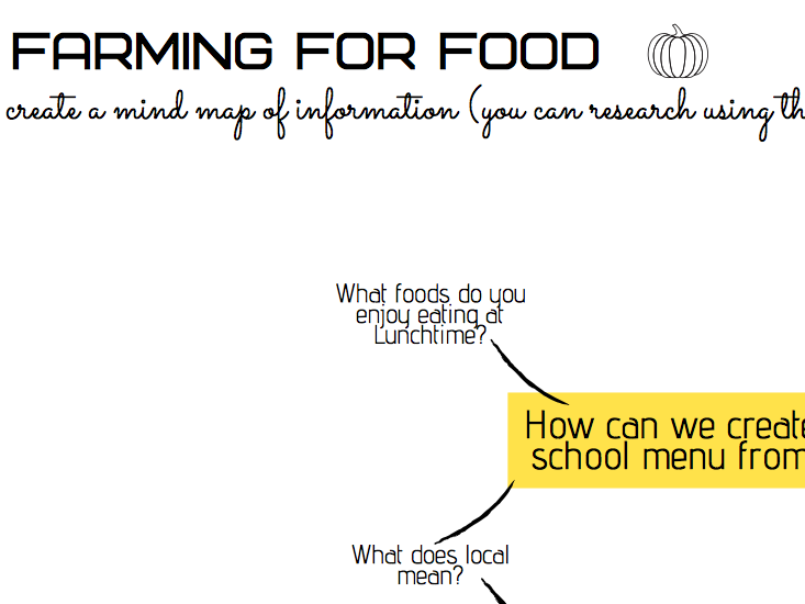
This resource contains a series of worksheets suitable for a geographical topic based on farming and growing local produce. Easy to make cross-curricular links with DT or Maths, these worksheets will also allow pupils to work on their research, graphing and mapping skills
There are 8 worksheets in this resource:
Farming for Food Mind Map
Mapping Farms in Hertfordshire
Types of Farms Pie Chart Diagrams
Where Does Your Food Come From?
Advantages and Disadvantages of Local Foods
What Makes a Healthy Meal?
Mapping Your Food Miles World Map
Seasonal Foods Chart
Get ready to roll the dice, climb ladders of eco-consciousness, and slide down the challenges of climate change in this thrilling board game ‘Climate Change Snakes and Ladders.’
In this captivating game, your pupils will traverse the board and witness the real impacts of climate change on different ecosystems and communities. From melting glaciers to endangered species, you’ll uncover the pressing issues that our planet faces today.
A fun-filled board game that sparks conversations about climate change and its impact on the world.
Teaches valuable lessons about sustainability, responsibility, and the power of positive actions.
Fosters teamwork and cooperation among players, promoting a sense of collective responsibility.
Beautifully designed with eye-catching colour and illustrations that bring the wonders of nature to life.
Easy-to-understand rules and game mechanics suitable for players of all skill levels.
High-quality and ideal for use with different classes or year after year.
This resource includes:
1 x Snakes and Ladders Game Board (Ideally printed in A3 format)
1 x Climate Change Scenario Worksheet
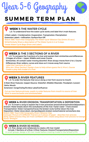
This scheme of work is suitable for KS2 Year 5-6 Geography and includes an 11-week plan and resources.
Week 1-5: Unit based on ‘Rivers’ focusing on the water cycle, three sections of a river, river features and river processes (erosion, transportation and deposition). The unit culminates in a small assessment piece which requires the children to build a “foil river” using the Learning Power Approach, followed by a written task. All assessment rubrics are included.
Week 6-11: Unit based on ‘Mapping Skills’ including lessons on grid references, compass points, contour lines and location knowledge. The plan also includes a detailed plan and resource for a Compass Fitness lesson outside which is ideal in the Summer Term.
Support your pupils’ learning and interest in Flag Geography with this 16-page colouring resource.
Including 16 pages, covering 6 different continents, pupils will need to research the colours of each flag before colouring the individual flags in themselves.
This resource is ideal as an opening introduction to a Global Location Scheme of Work, as a title page in exercise books or even as a display in the classroom.
Downloaded in PDF format.
Enhance your pupils’ geographical skills with a series of interpretation and analysis sheets and questions. This resource includes 8 PowerPoint slides with corresponding questions all focused on a different data presentation method. Ideal for preparing your pupils for exams and revising analysis skills. The high quality slides include annotation, examples and five scaled-ability questions.
The data presentation skills included in this resource are:
Climate Graphs
Population Pyramids
Choropleth Maps
Scatter Graphs
Pie Charts
Demographic Transition Model
Proportional Symbols Map
Divided / Stacked Bar Charts
Resource downloaded in PDF and PowerPoint Format.
Looking for a fun and educational way to introduce your children to the wonders of the Caribbean Islands? This activity pack is the perfect choice!
Jam-packed with activities that will engage and delight your child, while teaching them about the rich culture, delicious foods, and vibrant national dress of the Caribbean Islands. From designing a traditional Caribbean Island home to learning all about the wildlife on the various islands, there’s something for everyone in this activity pack.
Product Information:
45 Page Booklet
Information and Activity Pages
Covers 13 Different Caribbean Island Nations
High-Quality Pages
PDF Format
A high quality unit of work, PowerPoints and worksheets focused on the Geography of Sport.
This resource includes 8 lessons:
Benefits of Sport
National Sports & Geographical Patterns
The Sporting Environment
Factors Affecting Sports Participation
Globalisation & Sport
Mapping the Olympic Games
Choose an Olympic Host City
Exam-Style Question
Each of the eight lessons come with a corresponding PowerPoint with a learning outcome and engaging activities included on the slides.
Essential geographical skills of mapping, handling and displaying data are embedded throughout the lessons.
This resource can be downloaded in PowerPoint format and pdf format and includes 8 PowerPoint presentations and and 14 pages of worksheets.
Begin your lessons with an engaging activity that can be used to recap the previous lesson’s content or as a way to settle and focus your pupils. Each activity can be used to promote a wider classroom discussion and can be matched to the unit of work you are covering.
Over 30+ different Geography-themed starter activities.
Downloaded in PDF format
Eye-catching / high-quality design.
Can be printed or left on display screen for pupils.
Topics Included:
Population & Settlement
Coasts
Rivers
Sustainability
Tectonic Plates
Global Location Knowledge
Climate
Rainforests / Deforestation
Industry Types
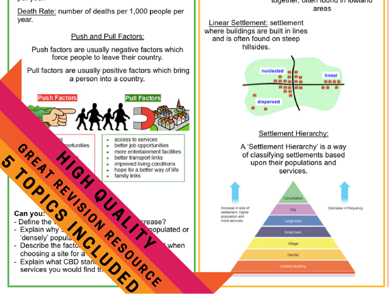
This resource includes 5 high-quality Geography Revision Crib Sheets for use at the end of a topic or when revising for an exam.
Aimed at the GCSE and Common Entrance Geography curriculums, the sheets include the main points of information as well as some exam-style questions to practise.
The five revision sheets included are:
Rivers - focusing on erosion/weathering, formation of river features, upper, middle and lower course of a river.
Population & Settlement - focusing on birth and death rate, push and pull factors and settlement types and hierarchy.
Weather & Climate - focusing on difference between weather and climate, factors influencing microclimates, types of rainfall and the 'Water Cycle.'
Coastal Landforms - focusing on the erosion and deposition processes that cause landforms such as headlands, bays, spits etc. The crib sheet also focuses on the management techniques in order to protect coastlines.
Earthquakes & Volcanoes - focusing on the layers of the Earth, types of plate boundaries and ways to predict and prepare for an earthquake or volcano.
Unlock the world of rivers with this engaging, curriculum-aligned educational resource, designed specifically for Upper KS2 students! Our River Features & Landscapes Pack brings the beauty and science of rivers to life, making geography both accessible and exciting.
What’s Inside?
Interactive PowerPoint Presentation
Our expertly crafted PowerPoint offers stunning visuals and easy-to-follow explanations of river features such as meanders, oxbow lakes, waterfalls, and more. Each topic includes a starter activity as well as a matching worksheet.
Ten Hands-On Worksheets
Each worksheet is packed with activities that challenge students to think critically, make observations, and draw connections to real-world examples. From labelling diagrams to interpreting data and mapping river courses, these worksheets help reinforce key concepts and keep students engaged.
This resource is ideal for a unit of work based on Rivers and includes a PPT with twenty-six slides and ten worksheets. Download in PPT and PDF format today.
Investigate the adaptations of 10 animals around the world with these flip book information worksheets.
How To:
Stick the information sheet or missing words worksheet into exercise book before sticking the animal picture over the top along the banner. Cut along the dotted lines of the animal picture to create a flip book.
This resources also comes with a ‘fill-in-the-gaps’ worksheet and word bank for pupils to complete, along with an answer key.
Animals included:
Camel
Orca
Cheetah
Zebra
Loggerhead Turtle
Chameleon
Lobster
Macaw
Hippopotamus
Rhinocerous
All resources downloaded in pdf format.
This advent calendar includes 25 days worth of questions aimed at KS3 pupils, covering a variety of topics, including:
Weather & Climate
Coastal Erosion
Population & Settlement
Tectonic Hazards
Great for use as a revision tool over the Christmas Holidays.
There are 25 questions all worth between 1 and 6 marks. The total marks of all 25 days of questions is 71 marks.
Save yourself time by completing a whole-class feedback sheet tailored to a Geography exam.
Plenty of space to give individual feedback at the bottom of the sheet to make it personalised.
Please let me know what you think by reviewing this resource.
3 x Year Group Geography-Themed Book Suggestions
Great for use as posters to promote reading and subject knowledge around the school or for use as a digital resource on homework sites etc.
Age groups divided into Year 3/4, Year 5/6 and Year 7/8