7 activities to support the understanding of the Naples and Campania Region as part of a location study aimed at Keystage 2 children.
Activity 1: Where is Italy?
Activity 2: The Regions of Italy
Activity 3: Base Map of Naples and the Campania Region
Activity 4: Reading Train Timetables: Circumvesuviana line table (The train around the Bay of Naples).
Activity 5: Holiday Brochure
Activity 6: Understanding Volcanoes- The Vesuvius Crater
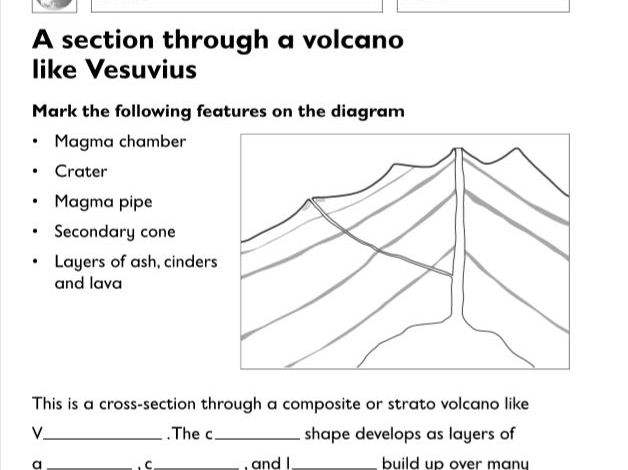
Activity 7: A Section Through a Volcano.
Leave a review
2 lessons covering UK Counties and Major Cities
Lesson 1: Counties in the UK
Learning objectives
Children should learn:
• the UK is divided into countries and counties.
Success criteria
Children can:
• understand that the countries in the UK are
divided into counties and can name some of the
counties.
Lesson 2: Major Cities in the UK
Learning objectives
Children should learn:
• about the major cities in the UK.
Success criteria
Children can:
• understand that there are a number of major
cities in the UK and can name and locate them.
Taken from LCP’s LKS2 Geography Resource File
5 worksheets to inspire learning and encourage geographical curiosity both at home or at school. Focused on a location study: South Wales. Taken from Keystage 2 Geography Resource File.
Available as PDF to print.
These worksheets include:
Rainfall and Temperature in the UK worksheet
Climate Statistics in Cardiff
Types of Coal
The Railway Children Comprehension
Reading a Map (Distrubition of Iron and Steel in South Wales)
In this unit children find out about the way people lived in the ancient Greek empire. They use a range of archaeological and written sources, select and record information and interpret the past in different ways. It is helpful if the children have: learnt about the way of life of people from different cultures who lived in the distant past; considered some of the attitudes and values of people living in the distant past, their motives and the results of their actions; used artefacts and pictures as sources of information.
Includes:
Contents
Introduction
Medium-term plan
Preparatory information
Useful websites about the Greeks
Lesson 1 Greece today
Lesson 2 Ancient Greek city states
Lesson 3 Athens and Sparta
Lesson 4 Triremes and hoplites
Lesson 5 The battle of Marathon
Lesson 6 Who did the ancient Greeks worship?
Lesson 7 Theseus and the Minotaur
Lesson 8 Ancient Greek theatre
Lesson 9 The play’s the thing
Lesson 10 The modern Olympic Games
Lesson 11 The ancient Olympic Games
Lesson 12 What we know about the ancient Greeks
Picture Prompt sheets
All lesson plans and activity sheets included.
Not sure? See our free download on Ancient Greek Theatre
Lesson Plan: How to identify different types of buildings
Learning objectives
Children should learn:
• that a locality includes a range of types of
building;
• about the function or significance of some
buildings in their own locality;
• how to annotate maps.
Success criteria
Children can:
• annotate a simple route map
Taken from LCP’s KS1 Geography Resource File
This pack includes 6 worksheets:
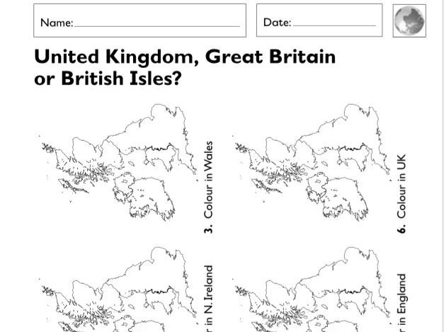
Understanding the difference between the British Isles, United Kingdom and Great Britain.
Make Your Own Wind Vane
Investigating Weather
Physical or Human features
Understanding where food comes from
From LCP KS1 Geography Resource File
The purpose of Geography is:
• to develop a knowledge and understanding of place on a local, regional and global scale, of the interconnections between places, of the significance of location, of human and physical environments, of people–environment relationships, and of the causes and consequences of change;
• to develop the skills needed to undertake geographical investigations (enquiry, map work, photographs and image interpretation
• to stimulate interest in, and to encourage an appreciation of, the world around us (environmental, social and cultural awareness); • to develop an informed concern for the world around us and an ability to take positive action (citizenship and sustainability).
3 lessons covering:
The Compass
How to use the compass
Directional language
Includes Lesson plans and work sheets
Lesson 1: The Compass and its uses
Learning objectives
Children should learn:
• the names of simple compass directions;
• simple locational language;
• to describe the location of features on a map
Lesson 2: Using the Compass
Learning objectives
Children should learn:
• the names of simple compass directions;
• simple locational language;
• to use simple maps;
• to plot a route on the ground.
Lesson 3: Using directional language
Learning objectives
Children can:
• begin to confidently use directional language.
Taken from LCP’s KS1 Geography Resource File
3 lessons including lesson plans and resources- What and where is Europe?
This has been written as two lessons as there is so much to learn about Europe. Lesson 1 will be the introduction, finding out about the continent as a whole, whilst Lesson 2 will concentrate on Europe related knowledge. The interactive games may be played in both lesson.
Lesson 1:What and where is Europe
Learning objectives
Children should learn:
• to begin to identify countries in Europe and their
major cities.
Success criteria
Children can:
• locate and understand that Europe is a continent
that has a number of countries and a range of
major cities
Lesson 3: Regions in Europe
Learning objectives
Children should learn:
• countries and capital cities in Europe;
• to work together to design a tour of a region of
Europe.
Success criteria
Children can:
• understand that Europe is a continent that has a
number of countries and can produce a tour of a
region in a country in this continent.
Taken from LCP’s LKS2 Geography Resource File
1 lesson Plan: The geography of the United Kingdom and its surrounding sea
All worksheets included.
Learning objectives
Children should learn:
• the names of the countries of the UK;
• the names of the four capital cities of the UK;
• to identify characteristics of the four countries
and capital cities.
Success criteria
Children should be able to:
• name the countries of the UK;
• name the four capital cities of the UK;
• identify characteristics of the four countries and
capital cities
Lesson taken from LCP’s KS1 Geography Resource File
2 full lessons with resources, flipbook and worksheets
1st lesson:
Learning objectives
Children should learn: • that rocks and natural materials are chosen for particular purposes because of their characteristics
Learning outcomes
Children will be able to: • relate the use of some rocks and natural materials to their characteristics and say why they are used
Lesson focuses on describing the use of material in buildings.
Do you recognise this building? Try to describe it. • Describe the main building material(s) that was (were) used to make this building. • Are the materials natural or man-made? If the materials are man-made, what do you think the original material was? (e.g. glass is made from sandstone/silica) • Why do you think these materials have been chosen?
2nd lesson:
Learning objectives
Children should learn: • about planning a fair test and using results to draw conclusions
Learning outcomes
Children will be able to: • explain whether a simple test is fair and what the results indicate
Lesson focuses which rock is the most permeable?
Leave a review
Taken from our Geography Flipbook Activities Keystage 2 Years5&6
This unit contains
Water Flipbook page 1:
WaterAid at work
Flipbook page 2:Improving water supplies
The resource includes one page of teacher’s notes for every page in the flipbook,and each one includes learning objectives and outcomes,key questions and activity ideas.There are many suggestions on how to use the relevant flipbook page and associated activity sheet.
Learning Objective: Children should learn: • to understand that people in less economically developed countries may not have access to safe, clean water supplies
Learning outcomes: Children will be able to:
• appreciate some of the problems associated with water supply
• understand that important decisions about water use have to be made
5 worksheets to inspire learning and encourage geographical curiosity both at home or at school.
Available as PDF to print. Designed for Year 4.
These worksheets include:
Mapping Puddles Invesitagion
Soaking up Water Investigation
Regional Study: East Anglia
The Water Cycle
Rainfall in the UK
Leave a review
5 worksheets to inspire learning and encourage geographical curiosity both at home or at school.
Available as PDF to print. Designed for Year 3.
These worksheets include:
Instructions and templates to make a cardboard contours island (2 sheets)
River bend investigation
River speed investigation
Understanding Cities in the UK.
1x lesson with worksheets
Learning objectives
Children should learn:
• about the physical and human features of the
seaside;
• further develop their map and atlas skills.
Success criteria
Children can:
• identify human and physical features of the
seaside;use geographical vocabulary to talk
about the seaside;
• use maps/atlases/Internet to locate seaside
places
Taken from LCP’s KS1 Geography Resource File
5 Lessons including resources and lesson plans
Lesson 1: Where does water come from?
Learning objectives
Children should learn to:
• recognise the processes which make up the water
cycle;
• sequence the components of the water cycle;
• see that human uses of water are also part of the
water cycle.
Lesson 2: Where does water go?
Learning objectives
Children should learn to:
• understand what happens to rainfall when it
reaches the ground;
• undertake investigations in the field
Lesson 3: Weather around the world
Learning objectives
Children should learn to:
• investigate places;
• locate places using an atlas;
• describe what places are like in terms of weather
conditions;
• understand that different places experience
different weather/climate
Lesson 4: Where are hot and cold places found around the world?
Learning objectives
Children should learn:.
• to recognise broad global climate patterns;
• about weather and climate conditions around the
world
Lesson 5: Climate Patterns
Learning objectives
Children should learn to:
• describe the main climate patterns;
Taken from LCP’s LKS2 Geography Resource File
2 part lesson covering contours and relief specifically aimed at Year 3 pupils.
Includes lesson plans and resource sheets
Lesson 1:
Learning objectives
Children should understand:
• contours show the shape of the land (relief);
• how sea level is measured.
Success criteria
Children can:
• begin to understand how relief (the shape of the
land) is shown on OS maps;
• understand how sea level is assessed.
Lesson 2:
Learning objectives
Children should understand:
• there are two ways of representing height on an
OS map;
• contours show the shape of the land (relief);
• layer colouring is a third way of showing relief on
maps.
Success criteria
Children can:
• state how high above sea level a particular
feature is on an OS map;
• begin to understand how height and relief are
shown on OS maps.
Taken from LCP’s LKS2 Geography Resource File
Taken from our UKS2 WW1 Resources File.
This is Unit 5.
There are six units available for Upper Key Stage 2, each focusing on different curriculum subjects but also designed to complement one another to support cross-curricular planning. An overview, in the form of a Planning Chart, is also included.
Each unit contains Activity ideas packed with facts, suggestions for different abilities and for working both in and out of the classroom, one Activity sheet, two Visual resources and a photocopiable Factsheet. Supporting the units are two Timelines, a World War I Glossary and two Maps of Europe showing how the geographical landscape and country boundaries changed as a result of the war.
Lesson 1:A guide to Leper
Lesson 2:The impact of the landscape
Lesson 3: Belgium then and now
Lesson 4: The creation of new countries
Lesson 5:Here and there
Lesson 6: Can you find your way around Leper?
Lesson 7:National pride
Leave a review
The purpose of this lesson is: to discover why the landscape was crucial in the life of the ancient Egyptians
Children should learn:
• to make deductions about life in the past from
pictures of the landscape;
• how much of the life of Egypt depended on the
Nile.
Class objective:
• to discover the importance of the River Nile in
ancient Egypt.
Children should be able to:
• extract information about the landscape from
pictures;
• provide answers that show the relationship
between the geography of Egypt and the way of
life in the past
Includes Lesson Plan and Activity sheets where required
The Learning Outside the Classroom resource provides teachers with fun outdoor activities and great ideas.• Natural Area around School and Local Area.<br/>Appropriate for Early Childhood Education (Pre-K and younger). ECE-SC, ECE-SC-he
This resource includes 1 text with activities and questions. Text title:
Niagara Falls
The cards primarily address text-level objectives for each year group and focus specifically on reading comprehension of non-fiction texts. The cards are designed to encourage talk and develop listening and speaking skills.
There is a main text on the front of each of the reading cards. The main text is followed by talk time , where there are open-ended questions, which are designed to stimulate a personal response to the issues raised and encourage children to think about the card’s theme.
The questions encourage discussion between two to six people. Talk time questions that are preceded by a require children to refer back to the text and are suitable for prompting children’s written responses. The box contains an interesting fact related to the card’s theme. This should appeal to the children’s sense of wonder and fascination for the remarkable.
The reverse side of each card carries things to do box. This contains activities and challenges that are designed to enable children to pursue the main theme still further. The activities are mainly practical in nature, so that all children can succeed, whatever their levels of literacy
Leave a review