I've worked in primary teaching for over 10 years and specialise in creating fun and engaging educational resources, particularly for Geography and History.
I've worked in primary teaching for over 10 years and specialise in creating fun and engaging educational resources, particularly for Geography and History.
This lesson is part of Exploring Brazil, a Geography unit designed for students in KS2 (Y4-6), but can also be taught as a stand alone lesson.
It takes students on a tour of the geographical features of Brazil. First students investigate a satellite photo of South America. They then look at a map of Brazil itself to see what human and physical features they can spot (e.g. Brazilian cities, Amazon rainforest).
In the activity students identify human and physical features of Brazil. It is differentiated three ways:
Easier – Students label 10 physical features of Brazil.
Medium – Students draw in arrows and label 10 physical features of Brazil.
Harder – Students stick a map of Brazil into their book, draw in arrows and label 10 physical features.
Extension – Students use atlases to also identify 8 Brazilian cities.
If you like this resource, we would appreciate a review! We will happily send you a free resource in return for a review or useful suggestions/feedback. Contact us at ed@teachitforward.co.uk.
This lesson is designed for KS2 students. It can be taught as a stand alone lesson but is also available as part of three wider units, all of which are available on TES:
-Volcanoes
-Earthquakes
-Volcanoes & Earthquakes
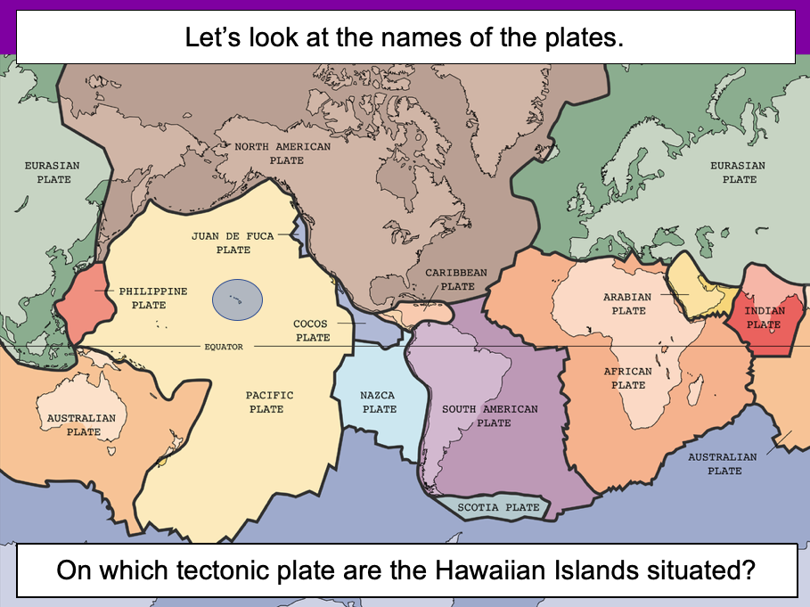
The presentation introduces the idea that the world’s crust is split into tectonic plates and looks at how these are related to volcanoes and earthquakes.
The activity challenges students to identify tectonic plates using a map. It is differentiated two ways:
Easier – Students identify the world’s tectonic plates using a colour-coordinated map.
Harder – Students identify the world’s tectonic plates using a plain map.
Extension – Students use an atlas to find out which tectonic plate countries of the world are located on.
If you like this resource, we would appreciate a review! We will happily send you a free resource in return for a review or useful suggestions/feedback. Contact us at ed@teachitforward.co.uk.
This lesson is part of Tropical Rainforests, a Geography unit designed for students in KS2, but can also be taught as a stand alone lesson. All resources are compatible with both Microsoft Office and Google Workspace.
First, the presentation introduces students to deforestation and then looks at the reasons the Amazon rainforest is being cut down (i.e. logging, farming and house building). Students are then encouraged to think about the positive and negative impacts of deforestation.
In the activity, students arrange these impacts of deforestation into a diamond 9, ranking them in terms of importance.
Easier - Students complete the diamond 9 and explain their reasoning for the most important statement they chose.
Harder - Students complete the diamond 9 and explain their reasoning for the most and least important statements they chose.
Extension - Students match topic words to their meanings.
If you like this resource, we would appreciate a review! We will happily send you a free resource in return for a review or useful suggestions/feedback. Contact us at ed@teachitforward.co.uk.
This lesson is part of Exploring Brazil, a Geography unit designed for students in KS2 (Y4-6), but can also be taught as a stand alone lesson.
The presentation first locates Brazil in the world’s climate zones and asks children to infer what the country’s weather and climate might be like.
Next, students look at three areas of Brazil in more detail – Manaus in the Amazon, Teresina in the caatinga desert region and Porto Alegre in the south of the country – and investigate a climate graph.
There are two activities:
Activity 1:
Students first investigate three climate graphs, looking at temperature and rainfall. Their challenge is to match each graph to an area of Brazil, explaining their reasoning for their choices. It is differentiated 2 ways:
Easier – Students match two statements to each climate graph, then match each graph to one of the three cities/regions.
Harder – Students write sentence describing the temperature and rainfall patterns in each climate graph, then match each graph to one of the three cities/regions.
Activity 2:
Students create their own Brazil climate graphs in Microsoft Excel using step-by-step instructions.
If you like this resource, we would appreciate a review! We will happily send you a free resource in return for a review or useful suggestions/feedback. Contact us at ed@teachitforward.co.uk.
This lesson is part of Investigating Rivers, a unit designed for upper KS2 (Y4-6).
The presentation takes students on a journey from the source to the mouth of the River Thames. Starting at Thames Head, the source of the River Thames, students investigate maps and satellite photos and try to identify river features along the way. Other locations include Windsor Castle, the Isle of Dogs in London and the mouth of the river at Southend-on-Sea.
The writing-based activity challenges students to first label each map/satellite photo and then write a paragraph describing the location and river features they can see. It is differentiated two ways:
Easier – Students have maps/satellite photos and cloze procedure paragraphs to complete.
Harder – Students have maps/satellite photos, a wordbank and write their own paragraphs.
If you like this resource, we would appreciate a review! We will happily send you a free resource in return for a review or useful suggestions/feedback. Contact us at ed@teachitforward.co.uk.
This lesson is designed for KS2 students and is a great introduction to any volcanoes or earthquakes topic. It can be taught as a stand alone lesson but is also available as part of three wider units, all of which are available on TES:
-Volcanoes
-Earthquakes
-Volcanoes & Earthquakes
The presentation investigates the structure of the Earth and looks into the basic composition of the inner core, outer core, mantle and crust.
Students then complete an activity which is differentiated three ways:
Easier – Students label layers of the Earth and complete cloze procedure paragraph (6 gaps).
Medium – Students label layers of the Earth and complete cloze procedure paragraph (10 gaps).
Harder – Students label layers of the Earth – including drawing arrows – and complete cloze procedure paragraph (10 gaps).
Extension – Students think about what they would like to find out about volcanoes or earthquakes or both, depending on which topic you are doing.
If you like this resource, we would appreciate a review! We will happily send you a free resource in return for a review or useful suggestions/feedback. Contact us at ed@teachitforward.co.uk.
This lesson is designed for KS2 students. It can be taught as a stand alone lesson but is also available as part of two wider units, both of which are available on TES:
-Volcanoes
-Volcanoes & Earthquakes
First the presentation introduces some of the world’s most famous volcanoes and classes them as active, dormant or extinct.
The activity then challenges students to locate volcanoes using an atlas or the internet (e.g. Google maps). Alternatively, a map of famous world volcanoes is also provided.
Easier – Students locate volcanoes using the map of famous volcanoes (writing numbers).
Medium – Students locate volcanoes using the map of famous volcanoes (writing volcano names).
Harder – Students locate volcanoes using an atlas.
(N.B. It is recommended you check the atlas has the relevant maps prior doing the activity.)
If you like this resource, we would appreciate a review! We will happily send you a free resource in return for a review or useful suggestions/feedback. Contact us at ed@teachitforward.co.uk.
This resource is part of Tropical Rainforests, a Geography unit designed for students in KS2, but can also be taught as a stand alone lesson. All resources are compatible with both Microsoft Office and Google Workspace.
This lesson is a great introduction to the world’s largest rainforest, the Amazon. First, the presentation introduces students to the Amazon and its incredibly biodiverse flora and fauna. It then goes on to look at the geography of the Amazon in more detail, specifically its location within the continent of South America.
The activity challenges students to identify a range of human and physical geographical features within South America, including the nine countries in which the Amazon rainforest is located.
In follow up extension activities, students identify the capitals of those countries and then complete a cloze-procedure paragraph about the Amazon.
If you like this resource, we would appreciate a review! We will happily send you a free resource in return for a review or useful suggestions/feedback. Contact us at ed@teachitforward.co.uk.
This lesson is part of Tropical Rainforests, a Geography unit designed for students in KS2, but can also be taught as a stand alone lesson. All resources are compatible with both Microsoft Office and Google Workspace.
First, the presentation introduces students to the different layers of the rainforest and some of the animals that live in each layer.
Students then complete a range of activities:
Activity 1:
In pairs, students match the layers of a tropical rainforest to descriptions.
Easier - Students have multicoloured descriptions. They match each layer to one green, blue and purple description.
Harder - Students have plain black descriptions. They match each layer to three other descriptions.
Activity 2:
Students identify and label the four layers of a tropical rainforest.
Easier - Students write one word for each layer.
Harder - Students write two words for each layer.
Extension:
Students cut out pictures of tropical rainforest animals and stick them in the layer in which they live.
If you like this resource, we would appreciate a review! We will happily send you a free resource in return for a review or useful suggestions/feedback. Contact us at ed@teachitforward.co.uk.
This lesson is part of Investigating Rivers, a unit designed for upper KS2 (Y4-6).
It challenges students to think about all the different ways we use water and where we get it from. Are these necessary (needs) or luxury (wants)?
Students then categorise these uses of water as agricultural, recreational, commercial/industrial or community. Lastly, they consider how we can balance human water requirements with those of Earth’s wildlife.
In the activity students sort photos of different water uses into six different categories:
Household
Commercial/industrial
Recreational
Agricultural
Community
Wildlife
In the extension activity, students classify each water use as either necessary or luxury and explain their reasoning.
If you like this resource, we would appreciate a review! We will happily send you a free resource in return for a review or useful suggestions/feedback. Contact us at ed@teachitforward.co.uk.
This lesson is part of Exploring Brazil, a Geography unit designed for students in KS2 (Y4-6), but can also be taught as a stand alone lesson.
It is a great introduction to South America. The presentation first locates the continent on a world map and then explores its political and physical geography.
There is a choice a shorter or a longer activity. In both, students identify the countries and capitals of South America. They are differentiated three ways:
Activity 1 (shorter):
Easier – Students have letter clues for countries and capitals marked on their map.
Medium – Students have capitals marked on their map.
Harder – Students have to mark capitals on their map themselves.
Extension – Students identify the capital cities of each country.
Activity 2 (longer):
Easier – Students have boxes for each country name and capitals marked on their map.
Medium – Students have capitals marked on their map.
Harder – Students have a blank map and have to mark their capitals themselves.
Extension – Students add other features to their map (e.g. Amazon rainforest) and complete a key.
If you like this resource, we would appreciate a review! We will happily send you a free resource in return for a review or useful suggestions/feedback. Contact us at ed@teachitforward.co.uk.
This lesson is part of Exploring the United Kingdom, a Geography unit designed for KS1 and lower KS2 (Y2-4).
The presentation first explains how every country – just like people – has its own special features and characteristics. It then introduces a variety of famous UK landmarks, sports and foods and challenges students to work out whether each is from England, Scotland, Wales or Northern Ireland.
The activity can be done in two ways:
Partner activity:
In mixed ability partners, students match 20 features and characteristics to the four UK countries.
Individual activity:
Students match 20 features/characteristics to the four UK countries.
Easier – Students match features/characteristics to each country (using stickers with labels).
Harder – Students match features/characteristics to each country and label each one (using stickers without labels).
If you like this resource, we would appreciate a review! We will happily send you a free resource in return for a review or useful suggestions/feedback. Contact us at ed@teachitforward.co.uk.
This lesson is part of Mountain Environments, a Geography unit designed for students in upper KS2 (Y4-6).
N.B. Ideally students have a grounding in latitude and longitude prior to this lesson. The unit Understanding Latitude & Longitude is an ideal introduction to the topic.
First the presentation introduces students to latitude and longitude and goes through how to find the coordinates of a point step-by-step. It then asks students to find the latitude and longitude of several world capital cities.
The activity and extension then challenge children to locate famous world mountains using their latitude and longitude:
Easier - Students locate 12 famous world mountains using latitude and longitude.
Harder - Students locate 16 famous world mountains using latitude and longitude.
Extension - Students add more famous mountains to their world map using latitude and longitude clues.
If you like this resource, we would appreciate a review! We will happily send you a free resource in return for a review or useful suggestions/feedback. Contact us at ed@teachitforward.co.uk.
Understanding Latitude and Longitude is a Geography unit designed for students in upper KS2 and KS3.
The unit contains a sequence of four lessons which are carefully designed to help students understand the key concepts of latitude and longitude and learn the skill of reading coordinates on a world map.
The planning overview and topic title page can be downloaded for free here. Lessons include:
L1 – Introduction to latitude and longitude
L2 – Finding latitude and longitude coordinates on a world map
L3 – Reading latitude and longitude with greater accuracy
L4 – Locating world capital cities using latitude and longitude
Each lesson includes a presentation and differentiated activities/worksheets.
If you like this resource, we would appreciate a review! We will happily send you a free resource in return for a review or useful suggestions/feedback. Contact us at ed@teachitforward.co.uk.
This resource is part of Exploring Australia, a Geography unit designed for students in upper KS1 and lower KS2 (Y2-Y4). All resources are compatible with both Microsoft Office and Google Workspace.
First the presentation introduces the concepts of human and physical before looking at some of Australia’s famous landmarks, from the Sydney Opera House to the Great Barrier Reef.
The activity challenges students to look at ten famous geographical features of Australia and identify them as human or physical:
Easier - Students look at each feature and circle human or physical.
Medium - Students draw each feature and circle human or physical.
Harder - Students identify each feature and label as human or physical.
Extension - Students complete a cloze-procedure paragraph about Australia.
If you like this resource, we would appreciate a review! We will happily send you a free resource in return for a review or useful suggestions/feedback. Contact us at ed@teachitforward.co.uk.
This resource is part of Exploring Australia, a Geography unit designed for students in upper KS1 and lower KS2 (Y2-Y4). All resources are compatible with both Microsoft Office and Google Workspace.
First the presentation investigates how Australia’s position closer to the Equator impacts its climate. Next, students are introduced to Australia’s three climate zones (tropical, arid and temperate) and find out how this effects weather in different parts of the country.
The activity challenges students to identify the climate zones of different Australian towns and cities:
Easier - Students identify the climate zones of 12 towns/cities.
Harder - Students identify the state and climate zones of 12 towns/cities.
Extension - Students investigate which climate zone has the most towns/cities and what this indicates about Australia’s population.
If you like this resource, we would appreciate a review! We will happily send you a free resource in return for a review or useful suggestions/feedback. Contact us at ed@teachitforward.co.uk.
This lesson is part of Exploring the United Kingdom, a Geography unit designed for KS1 and lower KS2 (Y2-4).
The presentation first introduces students to satellite photos before going on to challenge them to match satellite photos to famous UK landmarks (e.g. Wembley Stadium, Edinburgh Castle).
In the activity, students use their geography detective skills to describe satellite photos and infer which famous UK landmark or feature each one is. It is differentiated two ways:
Easier – Students write description of each satellite photo on a writing template sheet.
Harder – Students stick satellite photos into their exercise book and write descriptions next to them.
If you like this resource, we would appreciate a review! We will happily send you a free resource in return for a review or useful suggestions/feedback. Contact us at ed@teachitforward.co.uk.
This lesson is part of Investigating Rivers, a unit designed for upper KS2 (Y4-6).
It investigates rainfall patterns in the UK and how flooding can occur when too much rain falls in a short period of time. Students also explore the consequences of too little rain – i.e. drought – and the effects this can have.
In the comprehension activity, students answer questions based on a text called ‘Floods and Droughts’. It is differentiated two ways:
Easier - Students answer standard comprehension questions.
Harder - Students answer trickier comprehension questions.
If you like this resource, we would appreciate a review! We will happily send you a free resource in return for a review or useful suggestions/feedback. Contact us at ed@teachitforward.co.uk.
This lesson is designed for KS2 students. It can be taught as a stand alone lesson but is also available as part of two wider units, both of which are available on TES:
-Volcanoes
-Volcanoes & Earthquakes
The presentation investigates the five deadly features of a volcanic eruption including volcanic ash, lava flows, volcanic bombs, pyroclastic flows and mud flows (or ‘lahars’).
The activity challenges students to match pictures of each feature to a description. It is differentiated four ways:
Easier – Students match pictures of the five features of a volcanic eruption to the descriptions.
Medium – Students complete cloze procedure sentences. They then match pictures to each description.
Harder – Students complete cloze procedure sentences. They then match pictures to each description and add a title for each section.
Hardest – Children stick pictures of the five features of a volcanic eruption in their books and write their own description next to each one.
Extension – Which feature of a volcanic eruption do children think is the most deadly? Can they explain their answer?
If you like this resource, we would appreciate a review! We will happily send you a free resource in return for a review or useful suggestions/feedback. Contact us at ed@teachitforward.co.uk.
The Seaside is a Geography unit designed for students in upper KS1 and lower KS2 (Y2-Y3).
The planning overview, topic title page and vocabulary page can be downloaded for free here. Lessons include:
L1 – Identifying features of the seaside
L2 – Identifying human and physical features of the seaside
L3 – Locating seaside towns and cities of the UK
L4 – Investigating a seaside town - Lyme Regis
L5 – Identifying islands of the United Kingdom
L6 – Investigating what life is like on a small island
L7 - Packing for a seaside holiday
Each lesson includes a presentation and differentiated activities/worksheets.
If you like this resource, we would appreciate a review! We will happily send you a free resource in return for a review or useful suggestions/feedback. Contact us at ed@teachitforward.co.uk.