I am a Geography specialist who has also been teaching GCSE history for the past few years. I have uploaded some lessons for History and Geography. I hope people find them useful.
I am a Geography specialist who has also been teaching GCSE history for the past few years. I have uploaded some lessons for History and Geography. I hope people find them useful.
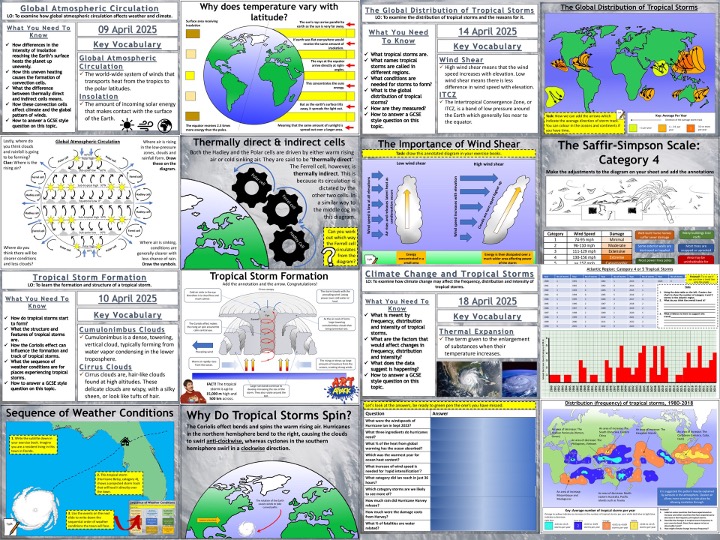
Complete Weather Hazards sequence of lessons for Unit 1, Section A of the AQA GCSE. Typhoon Haiyan is the case study tropical storm and Somerset Levels is the example of extreme weather in the UK.
The lessons included are detailed below.
Global Atmospheric Circulation
The Global Distribution of Tropical Storms
The Formation of Tropical Storms
Climate Change and Tropical Storms
Typhoon Haiyan: A Tropical Storm
Responses to Typhoon Haiyan
Reducing the Effects of Tropical Storms
Extreme Weather In The UK
The Somerset Levels Floods: 2014
Hope this saves you some valuable planning time.
/teaching-resources/shop/markthegeographer
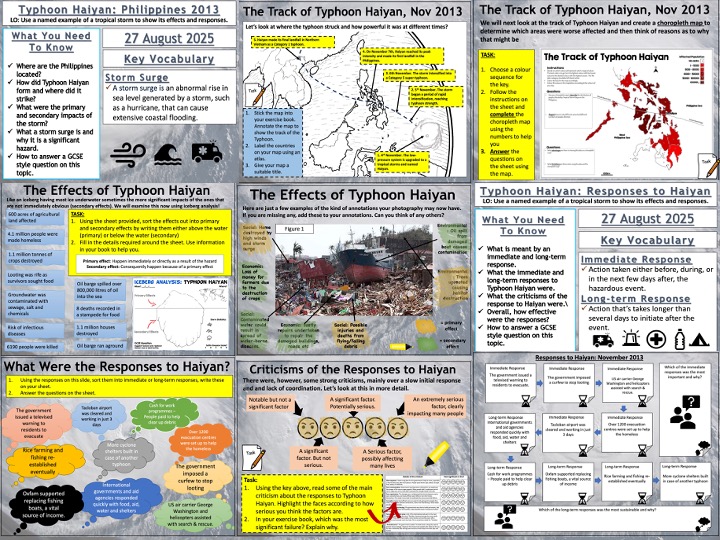
AQA GCSE Geography lesson for the new specification Unit 1A: In this lesson we look at a case study of Typhoon Haiyan.
The bundle contains two lessons.
**1. Typhon Haiyan 2013: Causes and effects. **We start with a short exercise where the students look at a photograph of destruction in Tacloban and list as many hazards and effects as they can think of. We then briefly look at the events of Typhoon Haiyan before writing a short paragraph describing its location. We then look at the causes and the students study a map of SST’s and then go on to annotate a map showing the track of the typhoon throughout the course of its life. We then look at the effects. The students complete a choropleth map (colouring by numbers) that shows the numbers of people affected and answer some questions regarding the map. We then watch a short clip of the effects and then annotate a photograph of the damage looking for primary and secondary effects. We finish with a GCSE-style practice question, using the same
photograph and there is some guidance and structure provided for the students.
**2. The Responses to Typhoon Haiyan. **There is a short, multi-choice retrieval practice starter before we begin based o the content learned last lesson. We start with the photograph we used in lesson 1, this time the students answer a question regarding immediate responses and what types of responses they think were undertaken in the wake of the typhoon. We then look at the actual responses and the students complete a worksheet that sorts them into immediate and long-term responses (some students will put them into chronological order). Following this we look at some of the criticisms of the responses and the students complete a highlighter activity to determine which were the most significant failings in the responses. We then tackle a 9-mark question and there is some guidance on the structure of their answers to help the students complete this.
Hope this saves you some valuable planning time.
/teaching-resources/shop/markthegeographer
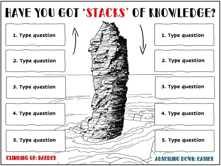
Old Man of Stoer version of a simple retrieval practice starter slide. Can also prompt discussion about how stacks form etc.
/teaching-resources/shop/markthegeographer
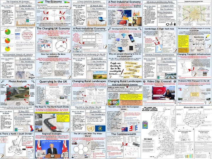
Complete Complete sequence of lessons for the AQA GCSE Geography Unit 2, Section B, The Changing UK Economy. The case study for the science park is Cambridge. Rural area examples are South Cambridgeshire and The Outer Hebrides.
Included are the lessons in this suggested sequence.
The Changing UK Economy
A Post-Industrial Economy
UK Science and Business Parks
The Environmental Impacts of Industry
Changing Rural Landscapes in the UK
Changing Transport Infrastructure
The North-South Divide
The UK in the Wider World
There is an additional revision map activity too.
Hope this saves you some valuable planning time.
/teaching-resources/shop/markthegeographer
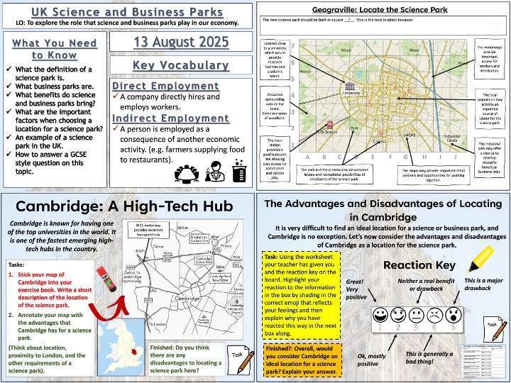
AQA GCSE Geography lesson for the new specification Unit 2B: In this lesson we examine the role that science and business parks play in our economy.
The lesson starts with a quick retrieval practice quiz. We then look at what a science park is and the students complete a cloze exercise whilst writing a short paragraph about science parks. We then consider a business park and the students have to work out the correct reasons for business parks locating on the outskirts of urban areas. The students then complete a decision making exercise called ‘Geograville: Where Should The Science Park Go?’. They annotate all the advantages the city has for a science park and then chose a suitable location and justify this. We then look at Cambridge. The students again annotate a map of the advantages of the location. They then complete an emoji exercise about the benefits and drawbacks of locating in Cambridge. We then finish with a GCSE-style practice question with some guidance.
Hope this saves you some valuable planning time.
/teaching-resources/shop/markthegeographer
Complete Complete sequence of lessons for the AQA GCSE Geography Unit 2, Section A, Urban Change in the UK and the Sustainable Urban Development lessons. The case study for the unit is London. SIngapore and Beijing are used as examples for the traffic management strategies lesson.
Included are the lessons in this suggested sequence.
Urban Change in the UK
Where Do People in the UK Live?
Introducing London
The Importance of London
Social Opportunities in London
Economic Opportunities in London
Transport and Urban Greening
Social Inequality in London
London’s Environmental Challenges
Air Quality and Waste Management in London
The Olympic Plan
Sustainable Urban Development
Planning for Urban Sustainability
Traffic Management Strategies
Additional lesson: Sustainable Living in Freiburg
Hope this saves you some valuable planning time.
/teaching-resources/shop/markthegeographer
Complete Complete sequence of lessons for the AQA GCSE Geography Unit 2, section A (Urban Change in the UK). The case study for the unit is London.
Included are the lessons in this suggested sequence.
Where Do People in the UK Live?
Introducing London
The Importance of London
Social Opportunities in London
Economic Opportunities in London
Transport and Urban Greening
Social Inequality in London
London’s Environmental Challenges
Air Quality and Waste Management in London
The Olympic Plan
Hope this saves you some valuable planning time.
/teaching-resources/shop/markthegeographer
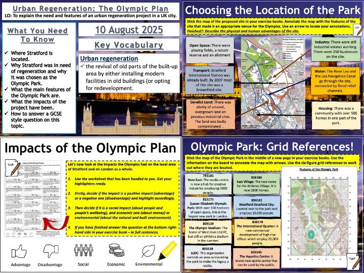
AQA GCSE Geography lesson for the new specification Unit 2A: In this lesson we look at the Olympic Plan and its legacy in the Lower Lea Valley. .
We start with a retrieval practice starter. We then look at where the Olympic Site is located, the students complete a heads and tails activity. We then look at the reasons why the Lower Lea Valley and Stratford in particular was in need of regeneration. The students watch a video clip about the changes that have taken place in Stratford since the Olympics. They note down what Stratford was like before and after. We then look at why the site was chosen and the students can annotate a map to show this. We then look at the features of the plan. The students have a grid reference exercise here to annotate their map with the features in the appropriate locations using six-figure grid-references. We then look at the impacts of the plan and the legacy. The students complete a highlighting activity looking at advantages and disadvantages, as well as social, economic and environmental impacts.
Once we have completed the diagram we tackle a 4-mark question. There is guidance should the pupils need it.
Hope this saves you some valuable planning time.
/teaching-resources/shop/markthegeographer
Complete sequence of lessons for the AQA GCSE Geography Unit 1, section C. The case study example of a river is the River Tees in North-East England and the example for flood management is Banbury.
Included are the lessons in this suggested sequence.
Drainage Basins
Long and Cross Profiles of a River
Erosion and Transportation
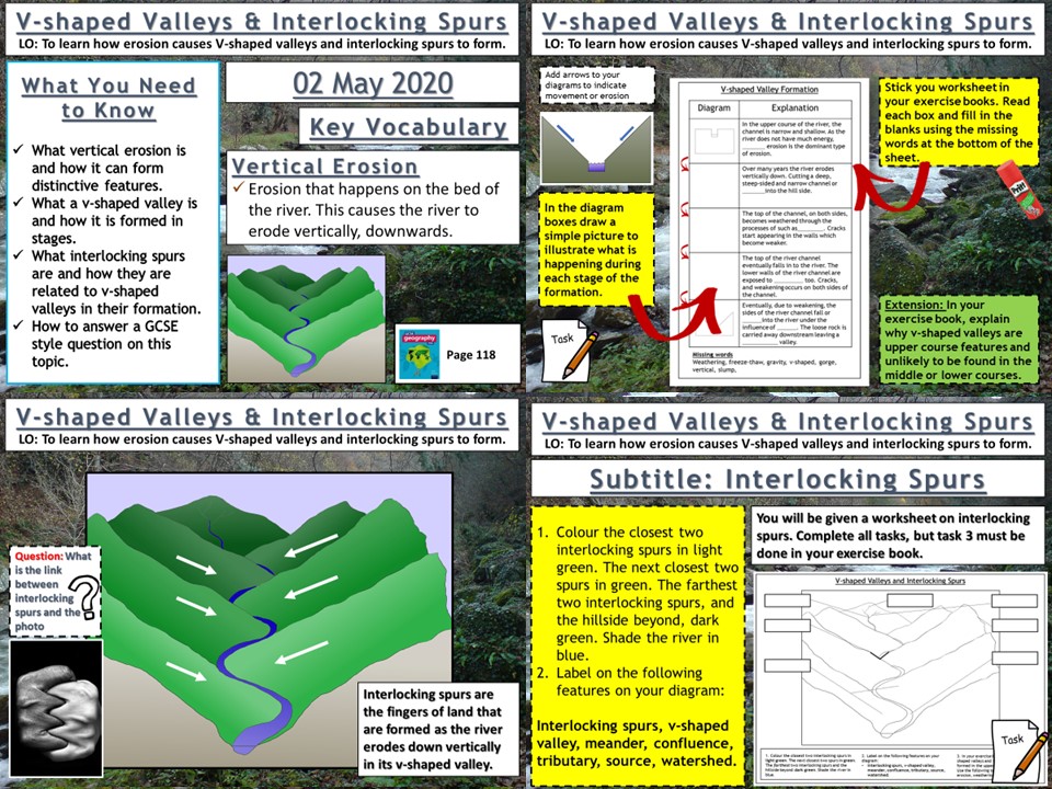
V-Shaped Valleys and Interlocking Spurs
Waterfalls and Gorges
Meanders and Oxbow Lakes
Depositional Landforms
Factors Increasing Flood Risk
Hard Engineering
Soft Engineering
Managing Floods at Banbury
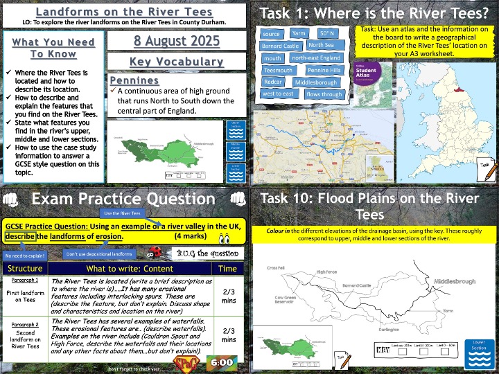
Landforms of the River Tees
AQA GCSE Geography lesson for the new specification Unit 1C: In this lesson we look at the formation of V-shaped valleys and interlocking spurs.
We start with a quick 1-5 question retrieval practice starter based on content already learned this unit. The students then look at iv-shaped valleys. After examining how they form the students then create a sequential diagram on how the formation of the valleys and annotate. There is a fill in the blank activity on this worksheet as well. We then move onto interlocking spurs and there is a worksheet for the students to colour in and annotate using the information on the slides. We finish with a 4-mark question and the students use some points on the board to help them complete this.
Hope this saves you some valuable planning time.
/teaching-resources/shop/markthegeographer
AQA GCSE Geography lesson for the new specification Unit 1C: In this lesson we look at landforms of the River Tees in North-East England.
We start with a retrieval practice grid based on the content learned so far in the unit. The lesson is based on an A3 worksheet and the students complete tasks on the worksheet starting with the upper section features and landforms and working our way down to the mouth in the lower section. There are supporting slides and videos for each of the ten tasks on the worksheet.
We finish with a 4-mark GCSE-style question where the students can use the information gained during the lesson within the context of an exam question.
Hope this saves you some valuable planning time.
/teaching-resources/shop/markthegeographer
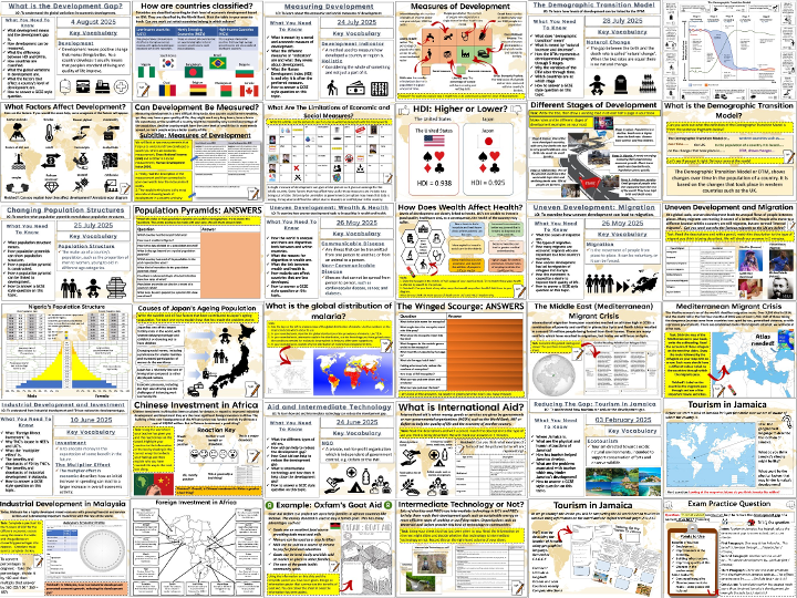
Complete sequence of lessons for Unit 2, Section B (The Development Gap) of the AQA GCSE. Jamaica is the case study for tourism.
The lessons included are detailed below.
What is the Development Gap?
Measuring Development
The Demographic Transition Model
Changing Population Structures
Wealth and Health
Migration
Foreign Investment and Industrial Development
Aid and Intermediate Technology
Fair Trade
Debt Relief and Microfinance
Tourism in Jamaica
Hope this saves you some valuable planning time.
/teaching-resources/shop/markthegeographer
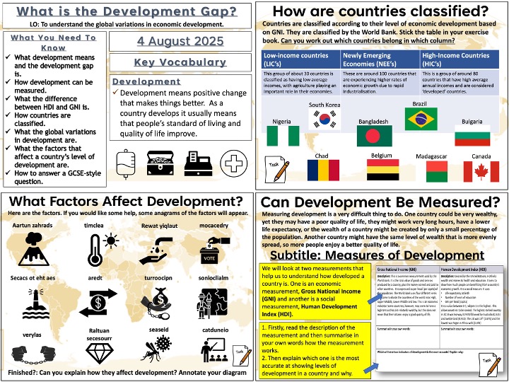
AQA GCSE Geography lesson for the new specification unit 2B. In this lesson we look at what development means and what the development gap is. We also look at the patterns of development globally and the reasons for uneven development.
There is an Ordnance Survey-themed retrieval practice starter included. We begin by looking at how development can be measured and comapre HDI with GNI using a table and the students summarise the information and determine which they think is the better measurement. We look at the global patterns of HDI and the students have a map with a variety of questions around the outside for them to answer. Then we examine how countries are classified into LIC’s, NEE’s and HIC’s, the students subsequently try to determine which countries belong in which categories. After completing the definition of the development gap, the students then complete an activity where they consider the factors that affect the level of development of a country. The students categorise these factors into social (historical), environmental, political and economic categories. The next slide has some picture clues and anagrams for the students to work out what the factors are. We then tackle a 6-mark GCSE-style question. There is a writing frame for structure and guidance on points to use.
hope this saves you valuable planning time.
/teaching-resources/shop/markthegeographer
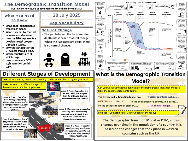
AQA GCSE Geography lesson for the new specification unit 2B. In this lesson we look at the Demographic Transition Model.
There is a multiple choice retrieval practice starter before we look at what the term ‘demographic transition’ means. The students have some sentence fragments to put in order. We then look at some key terminology that is needed for the lesson and the students match the description up to the term. We then look at the model itself an the students have a large A3 sheet to draw the model onto the template. The model is explained in stages and students make notes as they go along, drawing the three lines on too. There is a living graph activity to do when they have finished, by reading the statements in the boxes, they then have to work out which stage it applies to. We then look at examples of countries in the various stages of transition and the students create a diagram titled ‘The Road to Development’. We then tackle a 6-mark GCSE-style question. There is a writing frame for structure and guidance on points to use.
hope this saves you valuable planning time.
/teaching-resources/shop/markthegeographer
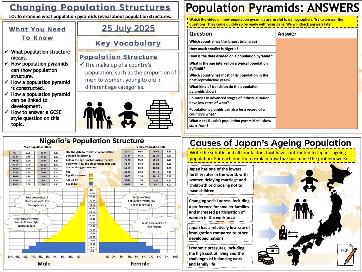
AQA GCSE Geography lesson for the new specification unit 2B. In this lesson we look at how population pyramids can reveal changing population structures and levels of development. There is a literacy starter based on the content learned so far in the unit. We begin with an introductory video on population pyramids and the students have a question sheet to answer whilst they watch the video. Using the information they have gleaned from the video they then annotate two contrasting population pyramids to consolidate how the graphs can reveal a great deal about a country’s level of development. We briefly look at dependency rations and the students have a go at calculating a simple example ratio. We then construct a population pyramid for Nigeria using a worksheet and the students can then consider what it reveals about the country. The students then examine an ageing population but looking at Japan’s changing population structure and the students complete a task looking at the factors that have contributed top this. We then tackle a 6-mark GCSE-style question using the population pyramids they annotated earlier. There is a writing frame for structure and guidance on points to use. .
hope this saves you valuable planning time.
/teaching-resources/shop/markthegeographer
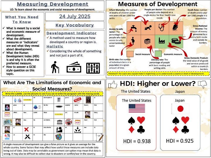
AQA GCSE Geography lesson for the new specification unit 2B. In this lesson we look at how development can be measured. There is a short multiple choice retrieval practice starter. We begin by looking at the difference between standard of living and quality of life. After this the students complete an activity matching the descriptions of the development indicators up with the pictures and colour coding them into social and economic indicators. The students then create a paragraph detailing why some indicators may not be reliable, but use the pictures to work out what the missing words might be. We then look at HDI and what is is made up of. The students complete a quick activity on matching the pictures to the benefits of using HDI as a development indicator. A short game of HDI higher or lower follows which is a fun way to spark debate and consolidate learning. We then tackle a 4-mark GCSE-style question with some suggested points to use on the next slide so the students can correct/feedback on their answer.
hope this saves you valuable planning time.
/teaching-resources/shop/markthegeographer
AQA GCSE Geography lesson for the new specification unit 2B. In this lesson we look at how aid and intermediate technology can help to reduce the development gap. There is a literacy retrieval starter where the students pick three words from the last few lessons to link together in a sentence. We then look at the different types of aid and students need to match the type of aid to the description. They then complete a cloze exercise to explain how aid can help to reduce the development gap. We look at the Goat Aid scheme from Oxfam and the students use a poster template to complete and colour in a Goat Aid poster. We then look at the definition of intermediate technology and the students complete a quiz on whether the examples on the board are intermediate technology or not. We then look at the example of Adis Nifas in Ethiopia and the students annotate a grid of symbols to show the features of the scheme. We then tackle a 6-mark GCSE-style question and the pupils use a writing frame and some point and evidence suggestions to help answer the question if needed.
hope this saves you valuable planning time.
/teaching-resources/shop/markthegeographer
AQA GCSE Geography lesson for the new specification unit 2B. In this lesson we look at how foreign investment (FDI) and industrial development can help to close the development gap. We start with a short task where students look into the different types of investments that can be made by foreign entities and TNC’s. Students use images to help complete a short paragraph. We then look at the reasons why TNC’s might choose to locate in an NEE or LIC and the students create a mind map. The students then create a diagram of the multiplier effect, annotating it by filling in the blanks on the slide. We then briefly look at the positive and drawbacks of TNC’s investing in countries, using Shell Oil as an example. We then use a map of investments in Africa, the students use an atlas to plot where the investments have been made. We then look at Chinese investment in Africa and the students complete a pictogram worksheet highlighting their reaction to the statements and recording why they reacted the way they did. We then look at Malaysia and industrial development. The students look at some development indicators, plot the economic sectors on a pie chart and then we briefly look at the drawbacks of the growth of the palm oil industry there . We then tackle a 9-mark GCSE-style question and the pupils use a writing frame and some point and evidence suggestions to help answer the question if needed.
hope this saves you valuable planning time.
/teaching-resources/shop/markthegeographer
AQA GCSE Geography lesson for the new specification unit 2B. In this lesson we look at how uneven development causes international migration. there is a retrieval practice starter based on development indicators. We start the lesson with a match-up activity where the students match the type of migration to the descriptions. The students then create a diagram that looks at the positives and negatives of international migration for the country and origin and the host country. We then complete a cloze exercise looking at economic migration to the UK. We then introduce the Middle East (Mediterranean) migrant crisis. The students complete a guided reading task then use an atlas to plot the routes of migrants in three example stories on a map of Europe. We then tackle a 4-mark GCSE-style question and the pupils use a writing frame and some points suggestions to help answer the question if needed.
hope this saves you valuable planning time.
/teaching-resources/shop/markthegeographer
AQA GCSE Geography lesson for the new specification unit 2B. In this lesson we look at why there are disparities in wealth and health both within and between countires. There is a rivers themed retrieval practice starter. We then look at the global state of wealth inequality and where the world’s wealth is and isn’t. We then look at how economic development has created inequalities in the USA. The students watch a video and note down the different types of inequality. The students complete a match-up activity identifying some of the main factors that lead to inequalities in wealth. We then look at health, the students complete a diagram using hexagons that shows how development might be linked to health. We then look at what malaria is and the students complete a colouring by numbers exercise to show the global distribution of malaria. They then watch the Disney information film ‘The Winged Scourge’ and answer questions. We then complete a mind map to show how some less developed countries are more at risk from malaria and categorise these into social, economic and environmental reasons. We then tackle a 6-mark GCSE-style question and the pupils use a writing frame and some points suggestions to help answer the question if needed.
hope this saves you valuable planning time.
/teaching-resources/shop/markthegeographer