Bring the unique and fascinating wildlife of Antarctica into your classroom with this engaging set of animal fact cards! These vibrant cards help students learn about some of the continent’s most remarkable creatures while developing skills in science, geography, and global awareness.
What’s Included:
PDF file – 6 pages: 2 fact cards per page – Featuring 12 Antarctic animals
Each card includes:
A full-colour photograph
Animal class (e.g. bird, mammal)
Details about habitat, diet, and lifespan
Fascinating curiosity facts to captivate learners
Perfect For:
Science lessons exploring animal classification, habitats, and adaptations
Geography units focusing on Antarctic ecosystems
Informative and eye-catching classroom displays
Independent or guided research tasks
Supporting EAL learners with visuals and clear, structured information
Cross-curricular learning across KS1, KS2, and adaptable for KS3
Learning Objectives:
Identify and classify animals by scientific characteristics
Understand the unique habitats and environmental conditions of Antarctica
Develop global knowledge and appreciation for animal diversity
Encourage curiosity, observation, and independent exploration
Explore more animals around the world:
Animals By Continents (Fact Cards) Bundle
Animals of Asia - Fact Cards
Animals of Australia - Fact Cards
Animals of Africa - Fact Cards
Animals of Europe - Fact Cards
Animals of North America - Fact Cards
Animals of South America - Fact Cards
Thanks for visiting!
If this resource supports your teaching, please consider leaving a rating or comment. Your feedback helps create more valuable content for educators like you!
Introduce your students to the fascinating wildlife of North America with this colourful and informative fact card set! Perfect for classroom displays, research tasks, or topic-based learning, each card gives learners a snapshot of animal life across this diverse continent.
What’s Included:
PDF file – 6 pages total: 2 fact cards per page – 12 animals featured
Each card contains:
A high-quality image of the animal
Animal class (e.g. bird, mammal, reptile)
Habitat, diet, and lifespan
A fun curiosity fact to spark interest and discussion
Ideal for:
Science lessons on animal classification and adaptations
Geography topics exploring North American ecosystems
Display materials and classroom decor
Reading comprehension and independent research
Cross-curricular links with literacy and global learning
Supporting EAL learners with visual and factual resources
Learning Objectives:
Identify and classify animals by scientific characteristics
Develop global knowledge and appreciation for animal diversity
Encourage curiosity, observation, and independent exploration
Explore animals across the globe:
Animals By Continents (Fact Cards) Bundle
Animals of Asia - Fact Cards
Animals of Australia - Fact Cards
Animals of Africa - Fact Cards
Animals of Europe - Fact Cards
Animals of South America - Fact Cards
Animals of Antarctica - Fact Cards
Thank you for viewing this resource!
If it supports your teaching, please consider leaving a review or rating — it really helps other educators and allows me to keep creating quality resources for you!
Landforms on Earth – Flashcards | Geography Display Resource
Support your students’ understanding of landforms with this visually engaging flashcard pack! Perfect for classroom displays, geography lessons, or interactive learning activities, these flashcards are designed to help children identify and describe key landforms found on Earth.
Contents:
*landforms
*geography
*flashcards
*visuals
*display
*understanding the world
This pack includes:
A printable PDF featuring 12 clear and colourful flashcards, each depicting a different landform
Notes:
I appreciate you taking a look at this resource. Please rate it and leave a comment if you enjoy it. Thank you.
Bring global geography to life with these engaging Landmarks in the World Flashcards, designed to help students identify famous landmarks and link them to their respective continents. Perfect for introducing world geography, enhancing location knowledge, and sparking curiosity about the world around us.
What’s Included:
7 PDF files, each featuring 8 flashcards of well-known landmarks from a different continent.
Each flashcard includes a high-quality visual of the landmark, the name of the landmark and the country it belongs to, and a colour-coded border to match the continent for easy identification and sorting.
Perfect For:
Geography lessons and units on continents and landmarks
Classroom displays and discussion prompts
Enhancing understanding of the world
Visual learners and EAL students
Quizzes, matching games, or memory activities
Topics Covered:
Identifying famous landmarks
Connecting landmarks to continents
World geography and map skills
Cultural awareness and global knowledge
Thank you for checking out this resource! If you find it helpful, please consider leaving a review or comment.
A fun and educational activity designed to help children explore geography and animal habitats across the continents! This differentiated resource is ideal for supporting both lower and higher ability learners as they identify and match animals to their native continents.
What’s Included:
PDF Pack – Includes 3 files:
Animal Continents Visual Mats
Activity Sheets – Higher Ability
Activity Sheets – Lower Ability
Topics Covered:
World geography
Continents
Animal habitats
Classification and sorting
Visual matching and reasoning
How it works:
Learners match animals to the continent where they are typically found.
Higher ability version requires children to match both the image and the name of the animal to the correct continent mat.
Lower ability version includes continent mats with the animal names already printed – children simply match the correct animal image cards.
Perfect for:
Geography lessons
Independent or group tasks
SEN and EAL support
Cross-curricular science topics
Spanish version coming soon!
You may also like:
Animals By Continents (Fact Cards) Bundle
World Physical Features By Continents - Fact Cards
I appreciate you taking a look at this resource. Please rate it and leave a comment if you enjoy it. Thank you.
Bring global geography to life with this informative and easy-to-use fact card pack, designed to support students in understanding key physical features across each continent. Perfect for lessons on world geography, continents, and landforms, these cards are ideal for independent research, displays, quizzes, or group activities.
What’s Included:
PDF Set of Fact Cards:
Explore major physical features around the world, organised by continent for clarity and easy reference.
Topics Covered:
The World
Physical Features
The Continents
General Geography
This resource supports learners in identifying and comparing features such as mountains, rivers, deserts, and other landforms across the globe.
You might also like:
Animals By Continents (Fact Cards) Bundle
Animal Continents Differentiated Activity Sheets - 2 levels of difficulty
Thank you for viewing this resource!
If you found it useful, please consider leaving a rating or review—your feedback helps others and supports my work.
Ignite curiosity and deepen understanding of volcanoes with this engaging and versatile resource pack, ideal for teaching geography, earth science, and natural phenomena topics. Suitable for a range of learners, this pack includes visual aids, interactive materials, and differentiated activities to support diverse classroom needs.
What’s Included:
PDF Presentation, covering:
-Ground-based volcano alert levels
-Suggested actions and potential impacts
Types of volcanoes
-Key volcano terminology
10 Volcano Fact Cards featuring the world’s most famous volcanoes
Three differentiated “Label the Volcano” worksheets
(High – Medium – Low difficulty levels)
Parts of a Volcano Anchor Chart – ideal for display or reference
Volcano Report Template – great for student-led research
Volcano Definitions – a quick-reference glossary
Thanks for checking out this resource!
If you find it helpful, please leave a review or rating—your feedback is truly appreciated!
Sumérgete en el apasionante mundo de los volcanes con este completo pack educativo, ideal para estudiantes de primaria o secundaria interesados en geografía, ciencias naturales y fenómenos naturales. Diseñado para facilitar el aprendizaje visual y conceptual, este recurso proporciona herramientas claras y dinámicas para entender cómo funcionan los volcanes y por qué son tan importantes.
Contenidos:
Presentación en PDF que incluye:
Niveles de alerta volcánica y sus significados
Posibles acciones preventivas y potenciales impactos
Clasificación y tipos de volcanes
Glosario de términos volcánicos clave, ideal para reforzar vocabulario científico
Tarjetas informativas ilustradas con datos relevantes sobre los 10 volcanes más famosos del mundo, perfectas para actividades grupales o exposición oral
Gracias por considerar este producto. Si te gusta, por favor, evalúalo y deja un mensaje.
Take your students on a virtual journey around the world with this engaging and visually rich PDF presentation featuring some of the most iconic landmarks across the globe. Perfect for geography, social studies, or cultural awareness lessons, this resource promotes global curiosity and historical understanding.
What’s Included:
Printable PDF presentation exploring 8 famous world landmarks.
The presentation start bu giving answer to the question “What is a world landmark?” and includes a fun challenge: “How many of these world landmarks do you recognize?”. Then, each of the eight landmarks will be introduced.
Each landmark is presented with:
A short introduction
Basic historical context
Fun curiosities and facts
A high-quality image
Featured Landmarks:
Buckingham Palace (United Kingdom)
Statue of Liberty (United States)
Eiffel Tower (France)
Great Wall of China (China)
The Roman Colosseum (Italy)
Alhambra (Spain)
Taj Mahal (India)
Sydney Opera House (Australia)
This resource offers a great way to build global awareness, visual recognition, and foundational understanding of cultural landmarks for primary and early secondary students.
Thanks for taking a look!
If you enjoy using this resource, please leave a rating or comment—your support is greatly appreciated!
Celebrate St. Patrick’s Day or enhance your geography and cultural awareness lessons with this engaging set of fact cards all about Ireland! This resource offers a fun and interactive way to introduce students to important and interesting facts about the Emerald Isle.
Perfect for group work, classroom displays, scavenger hunts, or independent reading stations!
Contents:
Ireland-themed general knowledge
Cultural and historical facts
St. Patrick’s Day connections
This pack includes:
PDF file with 10 fact cards, each featuring a unique and easy-to-read fun fact about Ireland
Ideal for KS1 and KS2
Topics covered in the cards:
introduction
The national flag
Who is St. Patrick?
Map of Ireland
Dublin
The Celtic Harp
Poulnabrone Dolmen
Corned beef and cabbage
Irish step-dancing
Shamrock
These cards make an excellent warm-up or complement to your St. Patrick’s Day activities or a country study on Ireland.
If you like this resource, you might be interested in:
Meet Ireland – Country Fact Presentation (Google Slides + PDF)
Thank you for checking out this resource!
If you find it helpful, please leave a review and a comment. Your feedback supports other teachers and helps improve future content!
Introduce your students to the rich culture and geography of Ireland with this visually engaging and informative presentation. Designed for use in Geography, Topic, or Cultural Awareness lessons, this resource offers a structured overview of the country’s key features in a simple, student-friendly format.
Contents:
Geography: map and major cities
Culture and identity
Key national facts
This pack includes:
Microsoft PowerPoint template (fully editable)
PDF version (ready to use or print)
Suitable for both in-person and digital learning
What’s included in the presentation:
Map of Ireland + key info
Main cities
Nickname of the country
Languages spoken
National holiday
National symbol
Brief historical background
Highest mountain
Longest river
Largest lake
Currency
This resource is a great way to spark curiosity, support cross-curricular learning, or kick off a country study project!
Looking for more about Ireland? You might be interested in:
Facts about Ireland (Fact Cards)
Thanks for viewing this resource!
If you enjoy it, please leave a rating and comment to support other educators. Your feedback means a lot!
Este recurso educativo incluye un conjunto de 10 tarjetas informativas a color, cada una dedicada a un desierto famoso del mundo. Cada tarjeta presenta características únicas de cada desierto junto con imágenes reales que ayudan a visualizar estos impresionantes paisajes naturales.
Contenidos a trabajar:
Comprensión lectora
Conocimiento geográfico
Memoria y retención
Curiosidad científica y cultural
Habilidades de exposición y comunicación
Trabajo colaborativo
Organización de la información
Desiertos incluidos:
Desierto del Sahara
Desierto de Arabia
Desierto Antártico
Desierto del Kalahari
Desierto de Namib
Desierto de Gobi
Desierto de Mojave
Desierto Ártico
Gran Desierto Australiano
Desierto de Atacama
Cada tarjeta incluye datos curiosos sobre un desierto y una imagen representativa.
Estas tarjetas son ideales para el aula de Geografía, actividades de exposición, centros de aprendizaje o murales temáticos. Recomendadas para Educación Primaria y Secundaria.
Listas para imprimir y usar en clase.
Notas:
Este recurso está disponible también en Inglés.
Deserts of the World – Fact Cards Set
Explore the unique wildlife of Australia with this vibrant set of Animal Fact Cards! Perfect for supporting lessons in science, geography, and understanding the world, these cards help children learn fascinating facts about animals native to the Australian continent.
What’s Included:
1 PDF file with 6 pages (2 fact cards per page – 12 animals in total)
Each card features:
Animal name and image
Animal class (e.g., mammal, bird, reptile)
Habitat
Diet
Lifespan
Curiosities – fun and unusual facts to spark engagement!
Perfect For:
Science lessons on animal classification and habitats
Geography units focused on Australia and its wildlife
Classroom displays and topic walls
-Cross-curricular projects
Independent research or group work
EAL and visual learners
Topics Covered:
Animal classes and characteristics
Australian ecosystems and biodiversity
Diet, habitat, and lifespan of animals
Unusual facts to encourage curiosity and discussion
Learning Objectives:
Identify and classify animals by scientific characteristics
Develop global knowledge and appreciation for animal diversity
Encourage curiosity, observation, and independent exploration
Thank you for viewing this resource!
If you enjoy using it, please consider leaving a rating or comment—your feedback is greatly appreciated!
Related resources:
Animals By Continents (Fact Cards) Bundle
Animals of Asia - Fact Cards
Animals of Africa - Fact Cards
Animals of Europe - Fact Cards
Animals of North America - Fact Cards
Animals of South America - Fact Cards
Animals of Antarctica - Fact Cards
Bring the wildlife of Europe into your classroom with these engaging Animal Fact Cards! Perfect for science, geography, and topic-based learning, this resource helps children explore the continent’s incredible biodiversity while building their knowledge of animal classification and habitats.
What’s Included:
1 PDF file – 6 pages total: 2 fact cards per page – 12 European animals in total
Each card includes:
Animal name and a clear, full-colour image
Animal class (e.g., mammal, reptile, bird)
Habitat, diet, and lifespan
Fun curiosity facts to inspire discussion and curiosity
Great For:
Science units on animals and classification
Geography topics on European habitats and wildlife
Displays or classroom information boards
Independent or group research tasks
Visual aids for EAL learners and topic-based reading
Encouraging cross-curricular learning and global awareness
Learning Objectives:
Identify and classify animals by scientific characteristics
Develop global knowledge and appreciation for animal diversity
Encourage curiosity, observation, and independent exploration
Continue the learning journey across the continents:
Animals By Continents (Fact Cards) Bundle
Animals of Asia - Fact Cards
Animals of Australia - Fact Cards
Animals of Africa - Fact Cards
Animals of North America - Fact Cards
Animals of South America - Fact Cards
Animals of Antarctica - Fact Cards
Thanks for stopping by!
If you enjoy this resource, please consider rating and leaving a comment—your feedback is incredibly helpful and much appreciated!
Explore the animal kingdom continent by continent!
This engaging bundle of Animal Fact Cards is the perfect resource to support lessons on animals, habitats, and world geography. Packed with key facts and colourful visuals, these cards help students deepen their understanding of animals across the globe.
Bundle Offer: Save £2 when you purchase this full set!
What’s Included:
7 PDF files (one per continent), each with 6 pages
2 fact cards per page – that’s 84 animal cards in total!
Each card features:
Animal name and image
Continent
Animal class (e.g., mammal, reptile, bird)
Habitat
Diet
Life span
Curiosities and fun facts to spark interest!
Perfect For:
Science lessons on animals and their habitats
Geography units on continents and biodiversity
Understanding the world (KS1/KS2)
Classroom displays and fact walls
Independent or group research
EAL support and cross-curricular projects
Topics Covered:
Animal classification
Global habitats and ecosystems
Geographic distribution of animals
Fascinating animal facts and behaviours
Learning Objectives:
Identify and classify animals by scientific characteristics
Develop global knowledge and appreciation for animal diversity
Encourage curiosity, observation, and independent exploration
Check out related resources to extend learning:
Animal Continents Differentiated Activity Sheets - 2 levels of difficulty
World Physical Features By Continents - Fact Cards
Thank you for exploring this resource! If you find it useful in your classroom, please consider leaving a rating or comment.
Take your class on a learning journey across Africa with these beautifully illustrated and informative Animal Fact Cards! Perfect for lessons on science, geography, and understanding the world, these cards help children explore Africa’s rich biodiversity while learning about animal classification, habitats, and fascinating facts.
What’s Included:
1 PDF file with 6 pages: 2 fact cards per page – for a total of 12 animals
Each card features:
Animal name and a vivid image
Animal class (e.g., mammal, reptile, bird)
Habitat
Diet
Lifespan
Curiosities – fun facts to spark engagement and discussion
Perfect For:
Science topics on animals and habitats
Geography lessons focused on Africa’s wildlife and ecosystems
Displays, discussion starters, and research prompts
Cross-curricular learning (science + geography)
EAL learners and visual learning styles
Independent work or group projects
Learning Areas Covered:
Animal classification and adaptations
African habitats: savannas, deserts, rainforests, and more
Food chains and diets
Life expectancy and survival traits
Fascinating animal behaviours and characteristics
Learning Objectives:
Identify and classify animals by scientific characteristics
Develop global knowledge and appreciation for animal diversity
Encourage curiosity, observation, and independent exploration
Complete your set with these related resources:
Animals By Continents (Fact Cards) Bundle
Animals of Asia - Fact Cards
Animals of Australia - Fact Cards
Animals of Europe - Fact Cards
Animals of North America - Fact Cards
Animals of South America - Fact Cards
Animals of Antarctica - Fact Cards
Thanks for exploring this resource!
If you find it helpful, please take a moment to rate and comment—your feedback is always appreciated and supports others in finding great resources.
Bring the incredible biodiversity of South America into your classroom with this vibrant set of animal fact cards! These engaging cards help students learn about some of the continent’s most unique creatures while building skills in science, geography, and global awareness.
What’s Included:
PDF file – 6 pages: 2 fact cards per page – Featuring 12 South American animals
Each card includes:
A full-colour photograph
Animal class (e.g. mammal, reptile, amphibian)
Details about habitat, diet, and lifespan
Fascinating curiosity facts to captivate learners
Perfect For:
Science lessons on animal groups, habitats, and adaptations
Geography units focusing on South American ecosystems
Informative and eye-catching classroom displays
Independent or guided research tasks
Supporting EAL learners with visuals and structured information
Cross-curricular learning across KS1, KS2, and adaptable for KS3
Learning Objectives:
Identify and classify animals by scientific characteristics
Develop global knowledge and appreciation for animal diversity
Encourage curiosity, observation, and independent exploration
Explore more animals around the world:
Animals By Continents (Fact Cards) Bundle
Animals of Asia - Fact Cards
Animals of Australia - Fact Cards
Animals of Africa - Fact Cards
Animals of Europe - Fact Cards
Animals of North America - Fact Cards
Animals of Antarctica - Fact Cards
Thanks for visiting!
If this resource is helpful in your classroom, please consider leaving a rating or comment. Your feedback supports the creation of more educational content for teachers like you!
Discover the incredible wildlife of Asia with this colourful and informative set of Animal Fact Cards! Perfect for bringing your science and geography lessons to life, these cards introduce students to fascinating animals from across the Asian continent and help develop their understanding of habitats, diets, and classifications.
What’s Included:
1 PDF file with 6 pages:2 fact cards per page – a total of 12 animals
Each card features:
Animal name and full-colour image
Animal class (e.g., mammal, reptile, bird)
Habitat
Diet
Lifespan
Curiosities – engaging facts that make learning fun and memorable
Perfect For:
Science units on animals and classification
Geography topics focused on Asia and its ecosystems
Displays, bulletin boards, or learning corners
Group research or independent fact-finding tasks
EAL learners and visual support
Cross-curricular learning (science + geography)
Topics Covered:
Animal classification
Habitats and ecosystems of Asia
Diet and lifespan of different species
Fun animal facts to enhance curiosity and engagement
Learning Objectives:
Identify and classify animals by scientific characteristics
Develop global knowledge and appreciation for animal diversity
Encourage curiosity, observation, and independent exploration
Continue the series with other continents:
Animals By Continents (Fact Cards) Bundle
Animals of Australia - Fact Cards
Animals of Africa - Fact Cards
Animals of Europe - Fact Cards
Animals of North America - Fact Cards
Animals of South America - Fact Cards
Animals of Antarctica - Fact Cards
Thank you for viewing this resource!
If you enjoy using it in your classroom, please consider leaving a review or comment—your feedback helps others and is always appreciated!
Bring geography to life with this engaging and informative set of Deserts of the World Fact Cards! Designed for KS2 and KS3 learners, this resource covers 11 of the world’s most famous deserts, offering a mix of key facts, striking visuals, and global context.
Skills focus:
Geographical Knowledge and Understanding
Visual Literacy
Reading Comprehension
Critical Thinking and Inquiry
Communication and Collaboration
Memory and Retention
Engagement and Motivation
Flexibility and Differentiation
Included Deserts:
Sahara Desert
Arabian Desert
Antarctic Desert
Kalahari Desert
Namib Desert
Gobi Desert
Mojave Desert
Arctic Desert
Great Australian Desert
Atacama Desert
What’s Inside:
10 fact cards – each featuring unique features with images of deserts of the world – perfect for classroom displays, interactive discussions, or visual aids.
Flexible use: whole-class teaching, geography displays, research starters, or quiz-style games
This ready-to-use resource is Ideal for visual learners and perfect for enriching geography lessons with real-world examples.
Notes:
This resource is also available in Spanish.
Tarjetas informativas: 10 Desiertos famosos del mundo
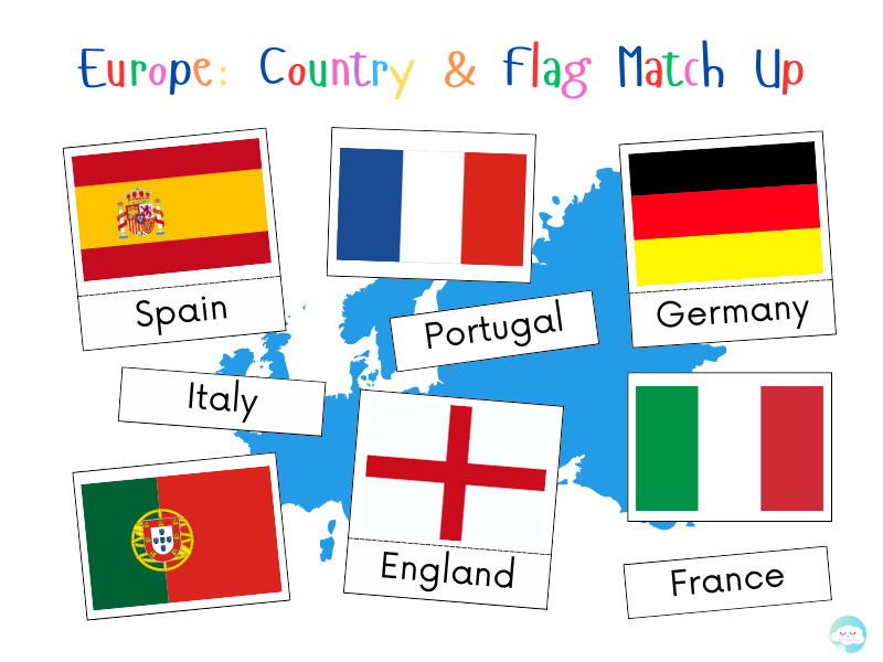
Europe: Country & Flag Match Up Game
Match the Flags to the Countries: European Geography Challenge!
Students will match the flags of 44 European countries to their correct names, helping them improve their geography skills while learning to recognize national symbols. Perfect for KS2 or KS3 learners, this resource is ideal for revision, class quizzes, or independent learning.
Skills Focus:
Geographical Knowledge
Visual Recognition
Memory and Recall
Map Literacy & Spatial Awareness
Critical Thinking and Matching Skills
Independent and Collaborative Learning
Motivation and Engagement
Contents:
Europe
European Countries
Match-up Puzzles
KS2
KS3
This pack includes:
PDF with cards ready to print and cut (4 pages)
Notes:
I appreciate you taking a look at this resource. Please rate it and leave a comment if you enjoy it. Thank you.