I've worked in primary teaching for over 10 years and specialise in creating fun and engaging educational resources, particularly for Geography and History.
I've worked in primary teaching for over 10 years and specialise in creating fun and engaging educational resources, particularly for Geography and History.
This is the free planning overview for London Zoo, a fun introduction to one of the world’s most famous zoos. A topic title page is also included.
This cross-curricula unit is designed for KS1 and lower KS2 students (Y2-4) and includes fully-planned lessons complete with differentiated activities and worksheets.
All the resources described in this unit plan are available on TES, either as individual lessons or as a bundle. Lessons include:
L1 – Writing a fact file about London Zoo
L2 – Taking a tour of London Zoo
L3 – Using compass directions at London Zoo
L4 – Using grid references at London Zoo
L5 – Matching animals to their habitat
L6 – The history of London Zoo
If you like this resource, we would appreciate a review! We will happily send you a free resource in return for a review or useful suggestions/feedback. Contact us at ed@teachitforward.co.uk.
This is the free planning overview for Volcanoes. A vocabulary page and topic title page are also included.
The unit is designed for KS2 students and includes seven fully-planned lessons complete with differentiated activities and worksheets.
All the resources described in this unit plan are available on TES, either as individual lessons or as a bundle. Lessons include:
L1 – Understanding the structure of the Earth
L2 – Investigating the structure of a volcano
L3 – Locating the world’s famous volcanoes
L4 – Investigating the five deadly features of a volcanic eruption
L5 – Understanding tectonic plates
L6 – Exploring the effects of volcanic eruptions on Montserrat
L7 – Why do people live near volcanoes?
A free newspaper report template is also included in this unit.
If you like this resource, we would appreciate a review! We will happily send you a free resource in return for a review or useful suggestions/feedback. Contact us at ed@teachitforward.co.uk.
This lesson is part of a wider unit called Exploring St Lucia and is designed to teach KS2 students about a contrasting non-European country.
This lesson looks at similarities and differences between St Lucia and the UK including:
– location in the world
– population
– languages
– currency
– heads of state
– physical geography
– types of employment
In the partner activity students sort statements about the countries into two groups – those describing St Lucia and those describing the UK. It is differentiated two ways:
Easier – Students sort statements about St Lucia and the UK (using stickers and a worksheet).
Harder – Students sort statements about St Lucia and the UK (completed in an exercise book).
Extension – Students think of similarities & differences between St Lucia and the UK.
If you like this resource, we would appreciate a review! We will happily send you a free resource in return for a review or useful suggestions/feedback. Contact us at ed@teachitforward.co.uk.
This is the free planning overview for Exploring St Lucia, a colourful introduction to the geography of St Lucia, a beautiful tropical island in the Caribbean. A topic title page is also included.
The unit is designed for students in KS2 and includes six engaging lessons complete with differentiated activities and worksheets.
All the resources described in this unit plan are available on TES, either as individual lessons or as a bundle. Lessons include:
L1 – Locating St Lucia in the Caribbean
L2 – Identifying the human and physical features of St Lucia
L3 – Investigating satellite photos of St Lucia
L4 – Using compass directions to locate places in St Lucia
L5 – Comparing the weather of St Lucia and the UK
L6 – Comparing St Lucia with the UK
If you like this resource, we would appreciate a review! We will happily send you a free resource in return for a review or useful suggestions/feedback. Contact us at ed@teachitforward.co.uk.
This is the free planning overview for Understanding Trade, a Geography topic designed to help student understand global trade. A topic title page is also included.
The unit is suitable for KS2 students from Y5 to Y6 and includes six fully-planned lessons complete with differentiated activities and worksheets.
All the resources described in this unit plan are available on TES, either as individual lessons or as a bundle. Lessons include:
L1 – Investigating where the products we buy come from
L2 – Understanding that all products have a supply chain
L3 – Exploring the chocolate supply chain
L4 – Investigating the UK’s biggest exports
L5 – Investigating the highest value exports of different countries
L6 – Is the banana trade fair?
If you like this resource, we would appreciate a review! We will happily send you a free resource in return for a review or useful suggestions/feedback. Contact us at ed@teachitforward.co.uk.
This lesson is part of Tropical Rainforests, a Geography unit designed for students in KS2, but can also be taught as a stand alone lesson. All resources are compatible with both Microsoft Office and Google Workspace.
The presentation introduces students to tropical rainforests, including some of the flora and fauna that live in them. Students then learn about the Earth’s tropical belt and the location of the various rainforests within it.
The activity challenges students to label features of a world map including the Equator, the Tropic of Cancer and the Tropic of Capricorn. Students then locate 8 of the world’s tropical rainforests.
Easier - Students use a prompt map and have activity clues.
Harder - Students use a prompt map but have no activity clues.
Extension - Students fill in the missing words in a paragraph about tropical rainforests.
If you like this resource, we would appreciate a review! We will happily send you a free resource in return for a review or useful suggestions/feedback. Contact us at ed@teachitforward.co.uk.
This is set of guided reading sessions designed to be used alongside The Diary of a Killer Cat by Anne Fine. These resources can be used across KS2.
The book follows the misadventures of a sarcastic cat called Tuffy who has a habit of bringing dead animals back to his owner, Ellie.
It is ideal for readers in Year 3 and Year 4 but can also be used with less-able readers in Year 5 and Year 6.
Included are 11 sessions of guided reading comprehesion questions. All questions are colour-coded and include:
Vocabulary questions
Retrieval questions
Summary questions
Inference questions
Prediction questions
Compare and contrast questions
Author choice questions
All resources are fully-editable and can be adapted easily if necessary. Answers are included.
If you like this resource, please review it. If you have any suggestions or feedback, contact me at ed@teachitforward.co.uk.
This lesson is part of Exploring the United Kingdom, a Geography unit designed for KS1 and lower KS2 (Y2-4).
The presentation first introduces students to satellite photos before going on to challenge them to match satellite photos to famous UK landmarks (e.g. Wembley Stadium, Edinburgh Castle).
In the activity, students use their geography detective skills to describe satellite photos and infer which famous UK landmark or feature each one is. It is differentiated two ways:
Easier – Students write description of each satellite photo on a writing template sheet.
Harder – Students stick satellite photos into their exercise book and write descriptions next to them.
If you like this resource, we would appreciate a review! We will happily send you a free resource in return for a review or useful suggestions/feedback. Contact us at ed@teachitforward.co.uk.
This lesson is part of Exploring Brazil, a Geography unit designed for students in KS2 (Y4-6), but can also be taught as a stand alone lesson.
The presentation introduces students to Brazil’s six main biomes including the tropical rainforest, caatinga (desert), Pantanal wetlands, cerrado (savannah) and Atlantic Forest. Students then read an information text to find out more.
In the activity, students write an information text about Brazil’s ecosystems. This can either be done as a short activity or as an extended write in Literacy. (N.B. The activity sheets need to be enlarged to A3 size to provide adequate space for writing.)
Short Activity:
Easier – Students match statements to each ecosystem and write them in each box.
Medium – Students add titles, then match statements to each ecosystem and write them in each box.
Harder – Students add titles and write their own sentences about each ecosystem in the box.
Extension – Students label the different ecosystems on the map, including drawings of animals found in each one.
Extended Writing Activity:
Easier – Students write an information text about Brazil’s ecosystems, including an introductory paragraph.
Harder – Students write an information text about Brazil’s ecosystems, including sub-headings and an introductory paragraph.
If you like this resource, we would appreciate a review! We will happily send you a free resource in return for a review or useful suggestions/feedback. Contact us at ed@teachitforward.co.uk.
This lesson is part of Exploring Brazil, a Geography unit designed for students in KS2 (Y4-6), but can also be taught as a stand alone lesson.
It takes students on a tour of the geographical features of Brazil. First students investigate a satellite photo of South America. They then look at a map of Brazil itself to see what human and physical features they can spot (e.g. Brazilian cities, Amazon rainforest).
In the activity students identify human and physical features of Brazil. It is differentiated three ways:
Easier – Students label 10 physical features of Brazil.
Medium – Students draw in arrows and label 10 physical features of Brazil.
Harder – Students stick a map of Brazil into their book, draw in arrows and label 10 physical features.
Extension – Students use atlases to also identify 8 Brazilian cities.
If you like this resource, we would appreciate a review! We will happily send you a free resource in return for a review or useful suggestions/feedback. Contact us at ed@teachitforward.co.uk.
This lesson is part of Exploring Brazil, a Geography unit designed for students in KS2 (Y4-6), but can also be taught as a stand alone lesson.
It gives students a chance to find out all about Brazil. The presentation introduces key vocabulary (e.g. population, currency) and then asks students what they know about Brazil and how they could find out more.
There are two activities:
Research Activity:
Students research Brazil using information sources (e.g. information books or suggested websites).
Easier – Students research famous landmarks, people, wildlife and Brazilian food.
Harder – Students choose their own topics to research.
Extension: – Students draw pictures for each topic or find appropriate images online.
Writing Activity:
Students write a fact file using the information they have found.
Easier – Students write about famous landmarks, people, wildlife and Brazilian food.
Harder – Students write about their own topics.
Extension – Students draw pictures or stick photos into the boxes for each topic.
If you like this resource, we would appreciate a review! We will happily send you a free resource in return for a review or useful suggestions/feedback. Contact us at ed@teachitforward.co.uk.
This lesson is designed for KS2 children. It can be taught as a stand alone lesson but is also available as part of two wider units, both of which are available on TES:
-Earthquakes
-Volcanoes & Earthquakes
The presentation looks at three famous earthquakes from the previous decade including Haiti (2010), New Zealand (2011) and Japan (2011).
The activity then challenges students to research an earthquake online (e.g. Simple Wikipedia) and write a fact file about it. A completed fact file about the earthquake in Christchurch in 2011 is included as an example.
Easier – Students research and create a fact file about their chosen earthquake.
Harder – Students research and create a fact file about their chosen earthquake plus insert a map and add photo captions.
If you like this resource, we would appreciate a review! We will happily send you a free resource in return for a review or useful suggestions/feedback. Contact us at ed@teachitforward.co.uk.
This lesson is designed for KS2 children. It can be taught as a stand alone lesson but is also available as part of two wider units, both of which are available on TES:
-Earthquakes
-Volcanoes & Earthquakes
The presentation investigates the five deadly features of earthquakes including ground shaking, tsunamis, landslides, raising/lowering of land and liquefaction.
It is followed up by an activity which is differentiated four ways:
Easier – Students match pictures of the five features of an earthquake to descriptions.
Medium – Students complete cloze procedure sentences. They then match pictures to each description.
Harder – Students complete cloze procedure sentences. They then match pictures to each description and add a title for each section.
Hardest – Students stick pictures of the five features of an earthquake in their books and write their own description next to each one.
Extension – Can students unscramble the jumbled up earthquake facts?
If you like this resource, we would appreciate a review! We will happily send you a free resource in return for a review or useful suggestions/feedback. Contact us at ed@teachitforward.co.uk.
This lesson is designed for KS2 children. It can be taught as a stand alone lesson but is also available as part of two wider units, both of which are available on TES:
-Earthquakes
-Volcanoes & Earthquakes
N.B. Ideally children have a grounding in latitude and longitude prior to this lesson. The unit Understanding Latitude & Longitude is an ideal introduction to the topic.
First the presentation introduces students to latitude and longitude and goes through how to find the coordinates of a point step-by-step. It then asks them to find the latitude and longitude of several world capital cities.
The activity challenges students to locate the world’s biggest earthquakes using their latitude and longitude. It is differentiated three ways:
Easier – Students locate 12 earthquakes using latitude and longitude.
Medium – Students locate 15 earthquakes using latitude and longitude.
Harder – Students locate 18 earthquakes using latitude and longitude.
If you like this resource, we would appreciate a review! We will happily send you a free resource in return for a review or useful suggestions/feedback. Contact us at ed@teachitforward.co.uk.
This lesson is designed for KS2 children. It can be taught as a stand alone lesson but is also available as part of two wider units, both of which are available on TES:
-Earthquakes
-Volcanoes & Earthquakes
The presentation first asks students how they would go about finding information about earthquakes. It then introduces them to the online encyclopedia Wikipedia.
The activity then challenges students to research the world’s 12 biggest earthquakes:
Easier – Students use Wikipedia to find one piece of information per earthquake.
Harder – Students use Wikipedia to find two pieces of information per earthquake.
Extension – Students answer questions about the world’s famous earthquakes using Wikipedia.
If you like this resource, we would appreciate a review! We will happily send you a free resource in return for a review or useful suggestions/feedback. Contact us at ed@teachitforward.co.uk.
This lesson is part of Exploring the United Kingdom, a Geography unit designed for KS1 and lower KS2 (Y2-4).
In the lesson, students learn about the four seasons and characteristics associated with each. First they have to guess each season using different clues. They then find out about the different types of weather associated with each season.
The colourful activity is differentiated three ways:
Easier – Students match 16 pictures (with labels) to the seasons.
Medium – Students match 20 pictures (with labels) to the seasons.
Harder – Students match 20 pictures to the seasons and label them.
If you like this resource, we would appreciate a review! We will happily send you a free resource in return for a review or useful suggestions/feedback. Contact us at ed@teachitforward.co.uk.
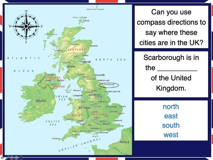
This lesson is part of Exploring the United Kingdom, a Geography unit designed for KS1 and lower KS2 (Y2-4).
N.B. If students are new to compass directions, use Introduction to compass directions to introduce the topic prior to this lesson.
First the presentation reminds students of the four cardinal compass directions. It then encourages them to use compass directions to describe the position of towns and cities around the UK.
In the activity, students have to find UK cities using compass clues. There are two differentiated activity worksheets:
Easier – Students locate cities using compass clues and starting letter clues.
Harder – Students locate cities using compass and harder starting letter clues.
Extension – Students complete cloze procedure sentence about the location of cities in the UK.
If you like this resource, we would appreciate a review! We will happily send you a free resource in return for a review or useful suggestions/feedback. Contact us at ed@teachitforward.co.uk.
This lesson is part of Exploring Spain, a Geography unit designed for upper KS2 students (Y4-6), but can also be taught as a stand alone lesson.
In the presentation students recap the 8 points of the compass and locate Spanish cities using these compass directions. They also learn how to locate cities in relation to each other (e.g. Valencia is north of Alicante).
The activity challenges students use all 8 compass directions to locate Spanish cities. It is differentiated three ways:
Easier – Students locate Spanish cities (with answer clues + cities marked on the map)
Medium – Students locate Spanish cities (with answer clues)
Harder – Students locate Spanish cities (no answer clues)
Extension – Students locate Spanish cities in relation to each other.
If you like this resource, we would appreciate a review! We will happily send you a free resource in return for a review or useful suggestions/feedback. Contact us at ed@teachitforward.co.uk.
This lesson is part of Exploring Spain, a Geography unit designed for upper KS2 students (Y4-6), but can also be taught as a stand alone lesson.
Students first learn about the Iberian peninsula. They then explore some of the main geographical features of Spain itself and categorise these into human (e.g. cities) and physical (e.g. mountains).
The activity challenges students to identify these features on a map of Spain. It is differentiated two ways:
Easier – Students identify human & physical features of Spain using a colour-coded map and word bank
Harder – Students identify human & physical features of Spain using a map & word bank
Extension – Students complete a cloze procedure text about the human and physical geography of Spain.
If you like this resource, we would appreciate a review! We will happily send you a free resource in return for a review or useful suggestions/feedback. Contact us at ed@teachitforward.co.uk.
This lesson is part of Exploring Spain, a Geography unit designed for upper KS2 students (Y4-6), but can also be taught as a stand alone lesson.
In the presentation students embark on a tour of Madrid, learning interesting facts about Spain’s capital city along the way. They visit sites including the famous Royal Palace, the Sun Gate and the Santiago Bernabeú Stadium, home of Real Madrid.
The lesson has two activities:
Quiz activity:
Students use an online encyclopedia to answer questions about Madrid.
Guided tour writing activity:
Students give their very own guided tour of Madrid.
Easier – Students write a guided tour of Madrid using a writing frame.
Harder – Students write a guided tour of Madrid by sticking images into their exercise books.
If you like this resource, we would appreciate a review! We will happily send you a free resource in return for a review or useful suggestions/feedback. Contact us at ed@teachitforward.co.uk.