I've worked in primary teaching for over 10 years and specialise in creating fun and engaging educational resources, particularly for Geography and History.
I've worked in primary teaching for over 10 years and specialise in creating fun and engaging educational resources, particularly for Geography and History.
This lesson is part of a wider Geography unit called Great Missenden – A Village Settlement which is designed for students in upper KS2 (Y4-6).
This lesson is the last in the unit and is ideally done after the fifth lesson – Surveying Great Missenden High Street using Google Street View.
The presentation briefly outlines the RICEPOTS system for categorising land use. It then introduces students to a survey map showing land use in Great Missenden High Street.
The activity challenges students to interpret information from the survey. In the extension activity students complete a bar chart showing land use on Great Missenden High Street.
If you like this resource, we would appreciate a review! We will happily send you a free resource in return for a review or useful suggestions/feedback. Contact us at ed@teachitforward.co.uk.
This lesson is part of a wider cross-curricula unit called London Zoo which is designed for KS1 and lower KS2 students (Y2-4).
The presentation first locates London Zoo within the UK and London itself. Students then find out a variety of interesting facts about the zoo.
The activity challenges students to write a fact file about London Zoo. It is differentiated four ways:
Easier – Students write cloze procedure sentences (one word per sentence)
Medium – Students write cloze procedure sentences (students write whole sentences)
Harder – Students write their own London Zoo fact file (using a sentence starter and vocabulary prompt)
Hardest – Students write their own London Zoo fact file (using just a vocabulary prompt)
If you like this resource, we would appreciate a review! We will happily send you a free resource in return for a review or useful suggestions/feedback. Contact us at ed@teachitforward.co.uk.
This lesson is part of a wider cross-curricula unit called London Zoo which is designed for KS1 and lower KS2 students (Y2-4).
The engaging presentation first introduces students to compass directions. It then challenges them to describe the location of animals at London Zoo using north, east, south and west.
In the activity, students describe the position of animals at London Zoo using compass directions. It is differentiated two ways:
Easier – Students have colour coded questions so they can locate animals quickly.
Harder – Students have to find the animals themselves.
Extension – Students are challenged to state the position of animals in relation to other animals (e.g. The owls are north of the gibbons).
If you like this resource, we would appreciate a review! We will happily send you a free resource in return for a review or useful suggestions/feedback. Contact us at ed@teachitforward.co.uk.
This lesson is part of a wider Geography unit called Great Missenden – A Village Settlement which is designed for students in upper KS2 (Y4-6).
First the presentation introduces students to satellite photos. It then challenges them to use their detective skills to identify various human and physical geographical features in and around Great Missenden.
In the writing activity, students try to identify features in satellite photos of Great Missenden, explaining the reasoning behind their ideas. It is differentiated three ways:
Easier – Student identify one feature in each satellite photo.
Medium – Student identify two features in each satellite photo.
Harder – Student identify three features in each satellite photo.
Extension - Students sort the features they have found in the satellite photos into human and physical geographical features.
If you like this resource, we would appreciate a review! We will happily send you a free resource in return for a review or useful suggestions/feedback. Contact us at ed@teachitforward.co.uk.
This lesson is part of a wider Geography unit called Great Missenden – A Village Settlement which is designed for students in upper KS2 (Y4-6).
First the presentation reminds students how to find grid references. It then challenges them to locate various geographical features in Great Missenden using 4-figure grid references.
In the activity, children locate features of Great Missenden using grid-references. It is differentiated three ways:
Easier – Students locate features of Great Missenden using 4-figure grid references (with clues).
Medium – Students locate features of Great Missenden using 4-figure grid references (no clues).
Harder – Students locate features of Great Missenden using 6-figure grid references.
Extension – Students complete sentences using compass directions to describe the location of features of Great Missenden in relation to each other.
If you like this resource, we would appreciate a review! We will happily send you a free resource in return for a review or useful suggestions/feedback. Contact us at ed@teachitforward.co.uk.
This lesson is part of a wider Geography unit called Great Missenden – A Village Settlement which is designed for students in upper KS2 (Y4-6).
In this lesson, students are introduced a high street survey, a great way of looking at land use in settlements. The presentation first outlines the RICEPOTS system for categorising land use and includes many photos of real world examples to aid understanding.
The activity challenges students to use Google Street View to work out the types of land use on Great Missenden High Street. It is differentiated three ways:
Easier – Students find the business name/land use of 10 places on Great Missenden High Street (with clues).
Medium – Students find the business name/land use of 14 places on Great Missenden High Street (with clues).
Harder – Students find the business name/land use of 14 places on Great Missenden High Street (no clues).
Extension – Students use Google Street View to survey a section of Great Missenden High Street by themselves.
If you like this resource, we would appreciate a review! We will happily send you a free resource in return for a review or useful suggestions/feedback. Contact us at ed@teachitforward.co.uk.
This resource is part of Exploring Australia, a Geography unit designed for students in upper KS1 and lower KS2 (Y2-Y4). All resources are compatible with both Microsoft Office and Google Workspace.
First the presentation recaps Australia’s location in the world. It then introduces Australia’s eight main states/territories and their capital cities.
The activity then challenges students to locate and identify Australia’s states/territories and major cities.
Easier - Students identify 8 cities and states/territories (first letter clues).
Harder - Students identify 10 cities and states/territories (no clues).
Extension - Students identify more Australian cities on their map.
If you like this resource, we would appreciate a review! We will happily send you a free resource in return for a review or useful suggestions/feedback. Contact us at ed@teachitforward.co.uk.
This resource is part of Exploring Australia, a Geography unit designed for students in upper KS1 and lower KS2 (Y2-Y4). All resources are compatible with both Microsoft Office and Google Workspace.
First the presentation investigates how Australia’s position closer to the Equator impacts its climate. Next, students are introduced to Australia’s three climate zones (tropical, arid and temperate) and find out how this effects weather in different parts of the country.
The activity challenges students to identify the climate zones of different Australian towns and cities:
Easier - Students identify the climate zones of 12 towns/cities.
Harder - Students identify the state and climate zones of 12 towns/cities.
Extension - Students investigate which climate zone has the most towns/cities and what this indicates about Australia’s population.
If you like this resource, we would appreciate a review! We will happily send you a free resource in return for a review or useful suggestions/feedback. Contact us at ed@teachitforward.co.uk.
This resource is part of Exploring Australia, a Geography unit designed for students in upper KS1 and lower KS2 (Y2-Y4). All resources are compatible with both Microsoft Office and Google Workspace.
First the presentation introduces satellite photos. Students initially examine satellite photos of famous world landmarks before moving on to investigate several Australian sites.
The activities challenge students to use their geographical detective skills to identify Australian landmarks from satellite photos:
Matching Activity:
Students match 10 Australian landmarks to their satellite photos.
Writing Activity:
Easier - Students investigate satellite photos of 8 Australian landmarks (using a writing frame).
Harder - Students investigate satellite photos of 10 Australian landmarks (writing in books).
Extension - Students choose an Australian landmark they would like to visit and explain why.
If you like this resource, we would appreciate a review! We will happily send you a free resource in return for a review or useful suggestions/feedback. Contact us at ed@teachitforward.co.uk.
This resource is part of Exploring Australia, a Geography unit designed for students in upper KS1 and lower KS2 (Y2-Y4). All resources are compatible with both Microsoft Office and Google Workspace.
This lesson is a great introduction to any Austalia topic. First the presentation looks at Australia’s location in the Southern Hemisphere before exploring the country’s vast size and the countries surrounding it.
In the activity, students are challenged to locate Australia on a world map and label other significant features:
Easier - Students label a world map (with hints).
Harder - Students label a world map (no hints)
Extension - Students use a map to identify countries surrounding Australia.
If you like this resource, we would appreciate a review! We will happily send you a free resource in return for a review or useful suggestions/feedback. Contact us at ed@teachitforward.co.uk.
This resource is part of Tropical Rainforests, a Geography unit designed for students in KS2, but can also be taught as a stand alone lesson. All resources are compatible with both Microsoft Office and Google Workspace.
This comprehension activity is based on the BBC’s My World Amazon Special. It is a great way for students to learn more about the effect of deforestation on a native Amazon tribe, the Arara.
It also introduces students to other key groups with an interest in the Amazon including a ranching family, student protestors and a conservationist.
In the activity, students answer questions about the documentary:
Easier - Students answer comprehension questions with time hints to help them find answers in the video.
Harder - Students answer comprehension questions with no time hints.
A transcript of the documentary is also included in case computers are in short supply.
If you like this resource, we would appreciate a review! We will happily send you a free resource in return for a review or useful suggestions/feedback. Contact us at ed@teachitforward.co.uk.
This lesson is designed for KS2 students. It can be taught as a stand alone lesson but is also available as part of two wider units, both of which are available on TES:
-Volcanoes
-Volcanoes & Earthquakes
First the presentation introduces some of the world’s most famous volcanoes and classes them as active, dormant or extinct.
The activity then challenges students to locate volcanoes using an atlas or the internet (e.g. Google maps). Alternatively, a map of famous world volcanoes is also provided.
Easier – Students locate volcanoes using the map of famous volcanoes (writing numbers).
Medium – Students locate volcanoes using the map of famous volcanoes (writing volcano names).
Harder – Students locate volcanoes using an atlas.
(N.B. It is recommended you check the atlas has the relevant maps prior doing the activity.)
If you like this resource, we would appreciate a review! We will happily send you a free resource in return for a review or useful suggestions/feedback. Contact us at ed@teachitforward.co.uk.
This lesson is part of Investigating Rivers, a unit designed for upper KS2 (Y4-6).
The presentation takes students on a journey from the source to the mouth of the River Thames. Starting at Thames Head, the source of the River Thames, students investigate maps and satellite photos and try to identify river features along the way. Other locations include Windsor Castle, the Isle of Dogs in London and the mouth of the river at Southend-on-Sea.
The writing-based activity challenges students to first label each map/satellite photo and then write a paragraph describing the location and river features they can see. It is differentiated two ways:
Easier – Students have maps/satellite photos and cloze procedure paragraphs to complete.
Harder – Students have maps/satellite photos, a wordbank and write their own paragraphs.
If you like this resource, we would appreciate a review! We will happily send you a free resource in return for a review or useful suggestions/feedback. Contact us at ed@teachitforward.co.uk.
This is the first lesson in Mountain Environments, a Geography unit designed for students in upper KS2 (Y4-6).
First the presentation introduces students to the topic and looks at some of the activities people do in mountains. It then introduces the key features of a mountain range.
The activity challenges students to identify the key features of a mountain environment. It is differentiated three ways:
Easier – Students identify 8 key features of mountains.
Medium – Students identify 10 key features of mountains.
Harder – Students label the key features of mountains in their exercise book.
Extension – Students match mountain vocabulary to their definitions.
If you like this resource, we would appreciate a review! We will happily send you a free resource in return for a review or useful suggestions/feedback. Contact us at ed@teachitforward.co.uk.
This lesson is designed for KS2 children. It can be taught as a stand alone lesson but is also available as part of two wider units, both of which are available on TES:
-Earthquakes
-Volcanoes & Earthquakes
First the presentation looks at how the Earth’s crust is split into tectonic plates. It then examines the causes of earthquakes, how they occur at the fault lines between tectonic plates and what the hypocentre and epicentre of an earthquake are.
There are three different activities to choose from which can be done in Geography and/or Literacy lessons. These include:
Quiz Activity
Students watch a video clip about earthquakes and answer comprehension questions about it. This is differentiated two ways.
Cloze Procedure Activity
Students fill in the blanks in an explanation text about earthquakes. This is differentiated two ways.
Writing Activity
Student write an explanation text about earthquakes. This is differentiated three ways and comes with vocabulary and sentence starter prompts.
If you like this resource, we would appreciate a review! We will happily send you a free resource in return for a review or useful suggestions/feedback. Contact us at ed@teachitforward.co.uk.
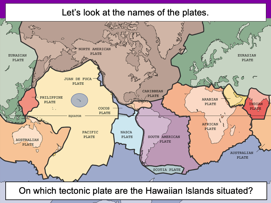
This lesson is designed for KS2 students. It can be taught as a stand alone lesson but is also available as part of three wider units, all of which are available on TES:
-Volcanoes
-Earthquakes
-Volcanoes & Earthquakes
The presentation introduces the idea that the world’s crust is split into tectonic plates and looks at how these are related to volcanoes and earthquakes.
The activity challenges students to identify tectonic plates using a map. It is differentiated two ways:
Easier – Students identify the world’s tectonic plates using a colour-coordinated map.
Harder – Students identify the world’s tectonic plates using a plain map.
Extension – Students use an atlas to find out which tectonic plate countries of the world are located on.
If you like this resource, we would appreciate a review! We will happily send you a free resource in return for a review or useful suggestions/feedback. Contact us at ed@teachitforward.co.uk.
This lesson is designed for KS2 students and is a great introduction to any volcanoes or earthquakes topic. It can be taught as a stand alone lesson but is also available as part of three wider units, all of which are available on TES:
-Volcanoes
-Earthquakes
-Volcanoes & Earthquakes
The presentation investigates the structure of the Earth and looks into the basic composition of the inner core, outer core, mantle and crust.
Students then complete an activity which is differentiated three ways:
Easier – Students label layers of the Earth and complete cloze procedure paragraph (6 gaps).
Medium – Students label layers of the Earth and complete cloze procedure paragraph (10 gaps).
Harder – Students label layers of the Earth – including drawing arrows – and complete cloze procedure paragraph (10 gaps).
Extension – Students think about what they would like to find out about volcanoes or earthquakes or both, depending on which topic you are doing.
If you like this resource, we would appreciate a review! We will happily send you a free resource in return for a review or useful suggestions/feedback. Contact us at ed@teachitforward.co.uk.
This lesson is part of Understanding Latitude and Longitude, a unit designed for students in upper KS2 and KS3. It can also be taught as a stand-alone lesson.
The presentation introduces the concept of lines of latitude and longitude, including the Equator and Prime Meridian, and goes on to explain their purpose and relationship to Earth’s hemispheres and poles.
In the activity, students have to identify all of these features on diagrams of the Earth. It is differentiated two ways and includes an extension:
Easier – Students have label clues and a vocabulary bank to help them.
Harder – Students have only a vocabulary bank to help them.
Extension – Students fill in the missing words in a text about latitude and longitude.
If you like this resource, we would appreciate a review! We will happily send you a free resource in return for a review or useful suggestions/feedback. Contact us at ed@teachitforward.co.uk.
This lesson is part of Understanding Trade, a Geography unit designed for students in upper KS2 (Y5-6).
The presentation starts by recapping what imports and exports are. It goes on to look at the UK’s top ten exports – mainly manufactured products – and the human and physical factors which help UK exports in this area.
In the activity, students use Microsoft PowerPoint to create a table of the UK’s top ten exports. They then use an online chart maker to produce either a pie chart or bar graph to illustrate this data. It is differentiated three ways:
Easier – Students use step-by-step instructions with some data already filled in
Medium – Students use step-by-step instructions
Harder – Minimal instructions – IT experts only!
If you like this resource, we would appreciate a review! We will happily send you a free resource in return for a review or useful suggestions/feedback. Contact us at ed@teachitforward.co.uk.
This lesson is an ideal introduction to the world’s three main climate zones.
It is part of Our World, a Geography unit designed for students in KS1 and lower KS2 (Y1-3), but can also be taught as a stand alone lesson.
First the presentation helps students understand that different places in the world have different climates. It then looks at the location of the Equator and North/South poles, and how these relate to the three main climate zones. To keep things simple, these are referred to as hot (tropical), mild (temperate) and cold (frigid).
The activity challenges students to locate the Equator and poles and then identify various climate zones around the world. It is differentiated two ways:
Easier – Students identify the climate zone of 8 numbered points around the world.
Harder – Students identify climate zone and continent of 8 numbered points around the world.
Extension – Students cut and stick pictures of four animals – elephant, lion, polar bear and penguin – onto their world climate zone map.
If you like this resource, we would appreciate a review! We will happily send you a free resource in return for a review or useful suggestions/feedback. Contact us at ed@teachitforward.co.uk.